Premise
Damon Crockett and I—a data scientist and an architectural historian, respectively—set out to explore the Streets of Los Angeles (SoLA) Archive with a typology of commercial architecture developed by the historian and preservationist Richard Longstreth. Our goal was to use Ed Ruscha’s images as evidence of what Longstreth described as “the multifaceted nature of commercial change since World War II,” tracing how patterns of commercial space established in the 1920s and the 1930s, and extended in the 1940s and 1950s, evolved in the 1960s, 1970s, and beyond.1 By applying Longstreth’s typology to Ruscha’s photographic archive, we hoped to understand how, in effect, Los Angeles became Los Angeles, a place defined by the horizontal urbanism of its arterial landscapes. Our approach was based on two assumptions: that pattern recognition is what computers do best and that a photography archive can be reverse engineered into a data set. Neither was entirely correct. Join us as we travel through Ruscha’s Los Angeles townscape on a journey of data discovery.
Prelude: 1972
In an interview from 1972, Ruscha sheepishly demurred that he was “not really a photographer,” even though he had self-published fourteen books of photographs. Ruscha meant that his photographs were not the point: for him “photography had become a basic tool of conceptual art,” and his books “hinged on something other than the images themselves.”2 By then, the images were significant themselves, but not as art, because they had been appropriated by the distinct cultural sphere of architecture. Loosely related to postmodernism, architecture’s appropriation of Ruscha’s work was connected to an intellectual interest in rejecting the canonical and high style in favor of the vernacular and everyday—like the buildings captured in the SoLA photographs.
In “Reyner Banham Loves Los Angeles” (1972), the British architectural historian converses with Ruscha in a Cadillac convertible at Tiny Naylor’s drive-in (7101 Sunset), discussing L.A.’s changing urban scene. Ruscha comments that it takes longer to tear down an old building than it takes to put up a new one. Banham swears he has seen the same standardized building in nine hundred different places. Ruscha agrees, quipping, “You’re not sure it’ll still be in the same location when you come back again.”3 Tiny Naylor’s was there when Ruscha photographed the 7100 block of Sunset Boulevard in 1973 and 1974, but in 1985 it was gone (fig. 19.1). All Ruscha could do, he explained decades later, was “record a street in a very faithful way,” regardless of what happened to it year to year.4
In 1972, the designers and theorists Robert Venturi, Denise Scott Brown, and Steven Izenour published Learning from Las Vegas, a book on architectural form, scale, and symbolism. Inspired by Every Building on the Sunset Strip (1966), their book included “Ed Ruscha elevations” that they made by pasting together photographs of casinos, motels, and billboards shot from a vehicle cruising the Las Vegas Strip.5 For Scott Brown, who encountered Ruscha’s work when she joined the urban planning faculty at the University of California, Los Angeles (UCLA), in 1965, the artist’s apparently nonjudgmental and inclusive attitude toward the commercial vernacular was essential.6 Every Building was almost “a scholarly monograph,” offering an expansive urban vision that took in “the whole hard face of the metropolis.” At UCLA, she encouraged students to “learn from the existing landscape” and taught them techniques of what she called town watching, using photography, diagramming, and description to comprehend the city’s “form, forces and functions.”7 Town watching became the basis for the analytical approach used in Learning from Las Vegas, as can be seen in the Ruscha elevations. Importantly, that book was “a study of method, not content,” intended for applications beyond Las Vegas and certainly appropriate for a car-oriented metropolitan agglomeration like Los Angeles.8
In 1972, when Longstreth was a PhD student at the University of California, Berkeley, and already grappling with Scott Brown’s admonitions about the vernacular landscape, he purchased several of Ruscha’s artist books at the university’s art museum. Like Ruscha, Longstreth had been taking pictures of Los Angeles buildings since 1966, when he returned to the city (he was born in Pasadena) for a summer job in the office of the architect Richard Neutra. Unlike Ruscha, his L.A. project was documentary from the beginning; it became a key component of the fieldwork that supported his scholarship, including two volumes on Los Angeles. By the time Longstreth completed City Center to Regional Mall (1997) and The Drive-In, the Supermarket, and the Transformation of Commercial Space in Los Angeles (2000), he had driven some five thousand miles in the L.A. Basin.9 In contrast to Ruscha but much like Scott Brown, Longstreth kept getting out of the car, examining individual buildings, isolating formal and functional types, and identifying patterns in the modern city.
Typology
In the 1970s, scholars turned to typological studies to make sense of the specialized buildings that proliferated with modernity and industrialization beginning in the 1800s. Nikolaus Pevsner’s A History of Building Types (1976) focused on nineteenth-century civic buildings, but he also examined some commercial and twentieth-century types, including supermarkets, shopping malls, and other “innovations in selling . . . caused by the motor car.”10 Chester Liebs picked up these developments in Main Street to Miracle Mile (1985), looking at specific roadside types of the gas, food, and lodging variety.11 In the 1980s, Longstreth used their work as the starting point for a study of generic commercial buildings, producing not a typological history but an actual typology: a classification scheme based on his field observations and photodocumentation of eighty thousand buildings from coast to coast. Longstreth argued that the typology was applicable nationally because commercial architecture was a “common language” across the country. Put another way, “even if architectural dialects were different, the underlying grammar was much the same.”12
Longstreth was looking for patterns in the built environment, for the rules of an urban grammar in effect in downtowns and on Main Streets, but also in the arterial landscape, a term identifying major surface roads carrying a heavy flow of local traffic.13 Despite an automotive orientation, arterials were generally thoroughfares whose growth outward from urban centers were related to transportation predating the combustion engine. In Los Angeles, these are the avenues that extend out from the city’s original plazas, their development spurred in the 1890s by the far-flung lines of streetcars and interurban railways. Long before the car overwhelmed the trolley, arterials like Sunset Boulevard were characterized equally by their commercial character and their urban attenuation.
Lined with mainly low-rise buildings whose architecture was as changeable as the retail occupancy, these commercial corridors were “fashioned to attract the eye and oftentimes to stimulate the senses.”14 At the same time, they were generally ordinary and utilitarian; frequently, they were taxpayer buildings erected where land values were low and rents were cheap, generating a modest income until eventual redevelopment. Unlike central business districts dotted with skyscrapers and civic monuments, arterial landscapes rarely symbolized their cities. Indeed, Longstreth observed that for much of the twentieth century, arterials were not even regarded as properly urban because they were dominated by automobiles. Los Angeles, he initially conceded, was “hard to accept as a real city” because of its largely unremarkable arterials; but thanks to Scott Brown’s theories and his own observations, Longstreth had learned to set aside those presumptions and to view arterials like Sunset Boulevard as the foundation of a new urban order.15
As in Ruscha’s Every Building, Longstreth’s commercial typology privileged elevation over other architectural attributes. He declared floor plans irrelevant because commercial buildings designed circa 1900 often featured open interiors to provide retail flexibility. While acknowledging that socioeconomic factors always informed commercial development, and recognizing that three-dimensional form offered important insights, Longstreth settled on the street front as best suited to “broad categorical divisions.” Because US commercial landscapes were born of the land platting and gridirons that became standard by 1850, parcels for commercial development were typically deep and narrow. This produced abutting buildings whose sides and rears were inconsequential but whose street frontage was key. Longstreth concluded, the facade gives the building “most of its identity.”16
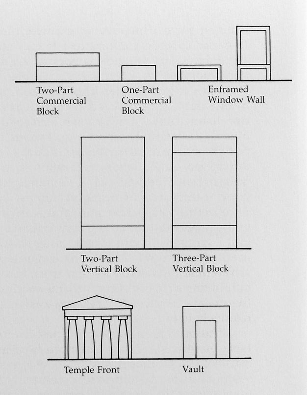
He grouped facades into standard forms with variations: one-part and two-part horizontal blocks, enframed and arcaded blocks, two-part and three-part vertical blocks, and temple fronts and vaults (fig. 19.2).17 These eight types are abstractions based on careful observation of buildings erected between 1850 and 1950. After 1950 the automobile’s spatial logic produced commercial forms that stressed three-dimensional volumes over plan and elevation. These new spaces possessed a variety of drive-in features, many originating in the earliest automotive accommodations of the 1920s; for instance, freestanding buildings were constructed on larger parcels of land with expanded off-street parking. While the fixed facades of storefronts became less important, the standard forms remain partially legible. Though setbacks and parking lots complicate perception of the street front, horizontal blocks are discernable, both multipart and combined with vertical units. Longstreth’s analysis jibed with what Venturi, Scott Brown, and Izenour discerned in Las Vegas: despite the variety of the Strip’s signage superstructure, its buildings possessed a notable sameness, their forms literally following function and context. Casinos downtown required “foot frontage” because they were oriented toward pedestrians on the sidewalks of a preautomotive street grid. Casinos on the Strip were oriented toward drivers on a multilane arterial; the need for comprehension from fast-moving cars produced the long and low buildings they called “decorated sheds.”18
For Longstreth, specifying compositional types as an underlying formal structure was essential because one of the most striking aspects of commercial space was its “inherent impermanence.” He noted that in arterial landscapes “change is endemic” because commercial corridors register socioeconomic and cultural shifts with a greater frequency than more permanent architectural forms.19 In storefront modernization, for example, the basic type remains comprehensible despite incremental change. This kind of “change and permanence” was a key finding of Learning from Las Vegas, too, in which the authors observed how competition across retail types produced an ongoing process of rebuilding, a “succession of facelifts,” with the original boxlike structures left intact.20 In typical commercial environments, change was prompted not by physical disrepair but by the visual aesthetics of signage and facades.
While Longstreth’s typology was historically focused, he believed that urban analysis based on photodocumentation of arterial landscapes had contemporary value. Even if decades-old photographs are “far removed from the present,” the conditions they reveal bring “the contemporary metropolitan order” into focus. As he explained, “The particulars have changed more than have the basic patterns.”21 This was true even in Los Angeles: it may have been a “pop city,” as Scott Brown called it, emphasizing its fickle ephemerality, but a thoughtful town watcher would find “pattern in sprawl, order in chaos.”22 This is what Longstreth discovered when deploying his typology in Los Angeles to track the development of its retail forms. Since he studied the same arterial landscapes that Ruscha captured in his photographs, and since he intended his typology as “an instrument for further research,” his typology was an obvious starting point for us as we attempted to adapt Longstreth’s analog methods to the digital age.23
Data Driven
“Did Ed Ruscha invent Google Street View?”24 The technologist Rob Walker posed this question in 2011, but he wasn’t the first person to make the connection. Within weeks of the launch of Google Street View (GSV) in May 2007, an Australian web developer noticed a resemblance between Ruscha’s motorized vision and Google’s new mapping feature. After Getty digitized Ruscha’s Sunset Boulevard images, and especially after it launched the “12 Sunsets: Exploring Ed Ruscha’s Archive” website enabling viewers to virtually drive along the boulevard’s nearly twenty-five–mile length between 1965 and 2007, the SoLA project really seemed like GSV avant la lettre.25 Moving through time and across the city is a thrilling virtual experience, as buildings, billboards, and palm trees accumulate into a detailed portrait of a particular urban place—similar to how people first experienced the now-ubiquitous GSV.
For Los Angeles, GSV picks up where “12 Sunsets” ends: Ruscha’s Sunset Boulevard photos from 2007 coincide with Google’s earliest images; since then, Google has recorded Sunset more than once per year. Twelve Ruscha Sunsets and twenty Google Sunsets offer an opportunity to explore the transformation of one of Los Angeles’ most famous streets over six decades, and it is easy to get lost in this virtual urban dérive. If, however, the goal is an analysis of urban form rather than an observation of urban incident, the volume of images overwhelms the endeavor. When town watching in search of type forms, anecdotal exploration must give way to organized inspection, which entails marshaling the capabilities of computation, machine-vision technology, and object recognition. Deploy any of these tools to scrutinize Sunset’s built fabric, and the actual differences between SoLA and GSV images stand out more than their perceived similarities.
Within Google Maps, the street view presents 360-degree panoramas from original images shot with high-definition digital cameras mounted atop a moving car, capturing multiple views from multiple vantage points. GSV cars are equipped with light-detection and ranging sensors that measure distance and dimensions with laser beams, wheel-mounted sensors that capture speed and direction, and GPS that pinpoints location. After more than a dozen images for every location and position are collected, they are aligned properly, corrected for tilt and distortions, adjusted for color and contrast, and stitched into composites by smoothing seams and minimizing transitions.26 These steps create the continuous photographs that seem to reproduce how we visually perceive our surroundings when moving through a given street. As viewers zoom and pan through Google Maps, most are oblivious to the gigabytes of geospatial metadata embedded in every GSV image.
That metadata makes GSV valuable to researchers, like those at the Massachusetts Institute of Technology’s Media Lab who used it in their Streetchange project (2015–19) to measure urban change by using a computer algorithm to inspect 1.5 million street blocks in five US cities (not L.A.). Researchers extracted image cutouts from GSV panoramas from 2007 and 2014 by precisely matching latitude, longitude, and left-right and up-down rotation. Then, the computer, via machine vision, analyzed the cutouts, inspecting object shape and pixel texture to distinguish ground, buildings, sky, and trees. Next, they deployed an automation algorithm to compare the same-place/same-point-of-view cutouts and calculate a metric of change, coding it qualitatively as improvement or decline based on perceptions of safety in urban environments.27 Streetchange’s automated inspection succeeded in detecting change because GSV is a data-collection project we mostly experience as a photographic one.
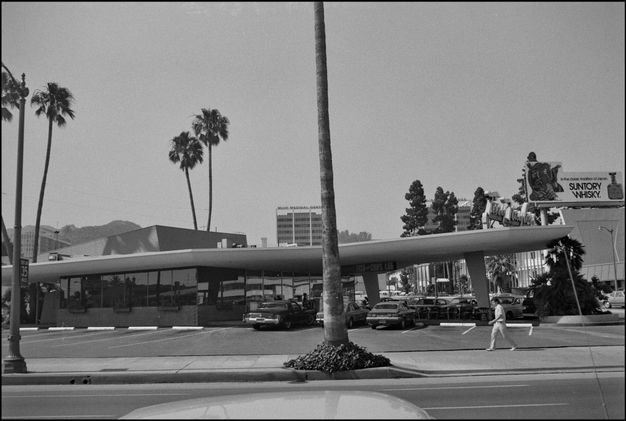
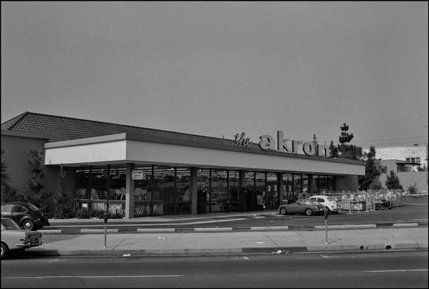
In contrast, the SoLA Archive is a photographic collection easily mistaken for a data-driven project. Once digitization began, with artificial intelligence generating geospatial and semantic tags for every scanned image, the SoLA project seemed like big data, a misreading that intensified with each comparison to GSV. While the pasteup techniques Ruscha used to make Every Building on the Sunset Strip may be an analog precedent to GSV’s digital alignment and stitching, Ruscha’s shooting logs are hardly equivalent to GSV’s structured spatial data. For instance, the log for Ruscha’s Sunset Boulevard shoot from 1973 reads: “Roll 1. Western Ave. East to across from Akron. Roll 2. Across from Akron to just West of Alvarado. Roll 3. West of Alvarado to past Water & Power Co.” Street number ranges are sometimes included in the logs—“Roll 14. 9984 to 10570”—as are key intersections and boundaries—“Sanborn Junction” and “end of Strip.”28 Cross streets, building numbers, and local monuments are forms of inchoate metadata that help place the images on Sunset, but only if one knows that Akron was the name of a home decor store at 4400 Sunset; that Water & Power Co. is short for the Metropolitan Water District of Southern California, whose headquarters were at 1111 Sunset; and that the address of the Playboy Club referenced on roll 11 was 8560 Sunset (figs. 19.3, 19.4).29 While the shooting logs seem like careful in-the-field notations, the information is as casual and informal as Ruscha’s trademark laid-back cool attitude.
The street numbers visible in the photos are valuable for identifying specific buildings, but an address, however useful as a data point, is not a geospatial location; and in contrast to the postproduction involved in GSV images, Ruscha simply developed the film without correcting misalignments caused by shifting zoom or the camera’s position. Ruscha’s in-the-field process is clear: working out of a pickup truck, the team drove slowly, shooting each building in the center of the frame. Because the camera was on a tripod fixed in the flatbed, the photographs seem to have visual consistency and continuity, block by block, year by year—or so it appears to a human scanning the digitized images. When a machine scans the collection, critical differences emerge.
Sunset Boulevard has two traffic lanes in both directions, and, per Ruscha’s production notebook, the truck traveled in the right lane with the camera pointed perpendicularly at buildings on the driver’s side.30 The team generally shot across three lanes of traffic, which is confirmed by images with cars in the passing lane that cut in front of the camera (figs. 19.5, 19.6). When shoots from different years are compared, however, there is a noticeable variation in the amount of asphalt visible in the foreground. Sometimes the sidewalk appears in the lower edge of the frame; sometimes the lane closest to the sidewalk is visible; and sometimes pavement markings and the adjacent lanes are also visible. Either the truck changed lanes, or someone adjusted the camera’s focal length; whatever the reason, the selected zoom varied between ten and twenty feet relative to the building wall. In elevation, that is equivalent to an additional story or more. Compare these inconsistencies to the GPS coordinates captured in real time and embedded into every GSV photograph, precisely plotting the location and position of each image. The implications of the imprecise data garnered from Ruscha’s photos are obvious: any data point selected for analysis to gauge comparative change is unreliable.
When Crockett and I trained a computer to inspect the open space above the building line of Sunset Boulevard’s street-facing elevations, we hoped this “Sky-o-Meter” would measure shifts in building heights and density by identifying the percentages of sky and non-sky in each frame, compared across shoots.31 The irregularities of Ruscha’s nondata-driven practice made image comparisons across years a frustrating exercise, one further undermined by a final photographic difference between SoLA and GSV images: Google’s images are not art, or even artistic, but each one is processed to correct color balance, boost contrast, and minimize the effects of light and shadow. This enhances their utility for machine-visioning tasks like semantic segmentation, which categorizes pixels into different classes to identify specific object types. In contrast, Ruscha’s images are characterized by their artlessness. He was famously unconcerned with tonal range, depth of field, or visual nuances. His photos are intentionally flat, making it difficult to discern changing details, like stucco cladding in the 1960s that was replaced by Dryvit in the 1980s, or the use of common brick in the 1970s versus that of face brick in the 1990s. This flatness added to the challenges we faced when trying to leverage the SoLA project as a historical equivalent of GSV.
Training a computer vision algorithm to recognize buildings in a photograph is more difficult than training one to recognize objects like cars, trash cans, palm trees, and signs. These objects have discernable formal patterns the machine can learn to detect. The more images the computer is fed, the more accurate its object-recognition results, at least with respect to urban equipment, be it street furniture or stoplights. The discrete forms of the individual buildings in Ruscha’s photos are more difficult for the computer to comprehend as recognizable and repeated patterns, much less ones that could be matched to Longstreth’s compositional types. Partly, this has to do with defining edges, where one building ends and another begins. On arterials like Sunset Boulevard—with its contiguous, if not always continuous facades—a party wall, a bulkhead, or an alley might define the boundary between buildings; but in Ruscha’s black-and-white, tonally flat pictures, these boundaries are not easily read by a machine.
Consider the property at 9009 Sunset, built as a food market in the 1930s and home to a burlesque club when it appears in Every Building thirty years later. In Longstreth’s typology, this is a two-part commercial block, one with a hipped roof and mod elements evocative of Paul R. Williams’s Hollywood Regency style. It sat at the street line, with two driveways and curbside parking spaces on either side. When Ruscha returned in 1973, it was the Roxy Theatre and had become a two-story building with a faux-deco pylon and marquee; subsequent photographs record changes in windows, signage, and paint colors, but the driveways interrupting the street wall remained constant until at least 2019 (fig. 19.7).32 The two buildings west of the Roxy—a restaurant at 9015 Sunset from the 1920s and Bank of America at 9021 Sunset from the 1950s—are clearly distinct, though separated by only a few inches. Because of the steep-pitched roof of the restaurant, there is visible space in the sky between it and the bank. Other contrasts abound: the restaurant facade is partially brick in contrast to the bank’s stone veneer; and while the restaurant is overwhelmed by a signage superstructure, the bank has an oversized parapet that shields rooftop parking. While a computer might detect varied surface patterns, the buildings’ proliferating planes and angles obscure the figure-to-ground relationship, and these buildings-as-objects are hard to define. A computer, even one well trained on streetscapes, struggles to distinguish one structure from another, or where a building ends and the sky, street, or sidewalk starts.
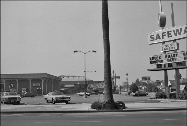
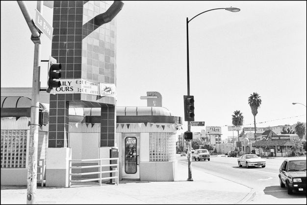
This is further complicated by the robust signage and advertising superstructure that defines L.A.’s arterials, something Banham had already observed in the 1970s. In Los Angeles: The Architecture of Four Ecologies (1971), Banham noted that the supposed “chaos” of the city’s commercial vernacular possessed logic and syntax—though not in ways that would make sense to a computer.33 A machine looking at images of 7070 Sunset (at La Brea Avenue) between the years 1973 and 1990 correctly identified a freestanding and nearly triple-height signpost as non-sky; meanwhile, a human looking at those same images can grasp how it changed. In 1973, the signpost advertised a Safeway supermarket occupying a building set back from Sunset to accommodate surface parking (fig. 19.8). Between 1985 and 1990, a retro-deco diner was built just behind the sign, which was reframed and clad with square tiles, probably to match the new building (fig. 19.9). Because of the change in focal distance in this shot, the top of the sign is out of the frame, and it is impossible to know what was advertised in 1990. While the non-sky became increasingly dense, the Sky-o-Meter failed to register the change over time because all the elements in the visual field—the big-box store, surface parking, knee wall, diner, and sign itself—have been compositionally part of the built fabric since 1973.
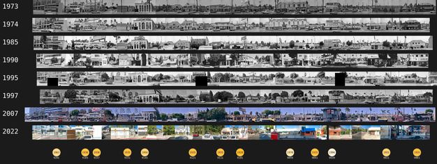
Despite the limitations of machine analysis and treatment of Ruscha’s photographs as data in a computational sense, Crockett successfully deployed automation to generate a data product from the archive to be analyzed offline: a set of composite SoLA photographs documenting the nine-mile stretch of Sunset Boulevard between Phyllis Street, which separates West Hollywood and Beverly Hills, and the 110 Freeway in downtown L.A. The composites contain around 250 images drawn from seven Sunset shoots (1973–2007) and Google Street View images from 2022.34 Each set depicts a specific range of buildings on the north or south side of Sunset with the horizontal strips and vertical stacks aligned as much as possible using automation rather than laborious manual correction (fig. 19.10). The remaining nonalignments are due to differences in the shoots already discussed, and the final composites are an easy-on-the-eye compromise between alignment and legibility. These composite photographs resemble nothing so much as analog contact sheets. As with contact sheets, they are useful for a quick overview scan and a detailed frame-by-frame scrutiny. By replacing the photographer’s loupe with the ability to digitally zoom and scroll, fifty years of stasis and change come into focus, as does Ruscha’s early insistence that his pictures are “simply a collection of ‘facts.’”35
Documentary Evidence
As facts, Ruscha’s pictures are data in an informational sense, documentation of and about Los Angeles, regardless of his motives in making them. This is how Banham regarded them in Los Angeles: The Architecture of Four Ecologies—the earliest transformation of Ruscha’s art into historical evidence—using them to substantiate an argument that “drive-in installations” were making serious contributions to architecture. Banham also referenced Ruscha’s “picture books” in the “Drive-In Bibliography,” taking them literally as compilations of eponymous building types.36 Importantly, his bibliography also included Anton Wagner’s Los Angeles: Werden, Leben und Gestald der Zweimillionstadt in Südkalifornien (1935), which for Banham was the beginning of a “literature of explication” of L.A.’s distinctive urbanism.37 Banham and Wagner parted ways in their methods of exploration. The German geographer walked as he photographed L.A., whereas Banham famously “learned to drive in order to read Los Angeles in the original.” Before that, Banham’s earliest “encounter with Sunset Boulevard”38 was about experiencing the city for the first time from a mobilized point of view, hence his ready embrace of Ruscha’s drive-by documentation.39
The evidentiary aspect of Ruscha’s work was also the starting point for Scott Brown and Venturi when analyzing change and permanence in Las Vegas. They moved in reverse chronological order from the Strip’s built reality circa 1972, comparing the content of their Ruscha elevations to postcards, maps, and brochures distributed by casino operators, hotel developers, and chambers of commerce. Combined with regular coverage of the Strip in local media outlets, this data created an instant archive for the architects to mine for evidence of change over time. Los Angeles lacked this sort of comparative material because its commercial establishments were rarely documented with the boosterism and fanfare of those in Las Vegas. This was true even of the Sunset Strip, with its nightclubs, restaurants, and diverse retail establishments. By the time Ruscha shot the photographs for Every Building, the swank and glamour that characterized Sunset between Crescent Heights Boulevard and Doheny Drive from the 1920s to the 1950s had given way to youth culture and rock and roll. Pandora’s Box and the Whisky a Go Go might turn up in the background of news coverage of Sunset’s curfew riots and other so-called hippie events of the 1960s, but not with regularity or comprehensiveness.
L.A.’s urban fabric was not entirely unrecorded: in addition to Wagner’s photodocumentation of the city, the studio of Dick Whittington, L.A.’s largest commercial photography practice from the 1920s to the 1980s, produced an archive of 700,000 negatives capturing the explosive metropolitan growth of these decades (which is why Longstreth used them in his studies of L.A.’s commercial space). Julius Shulman’s more specialized architectural photography studio did the same, but more selectively. The buildings Whittington photographed were those that were prominent because of their size or status—like the hotels, office buildings, and department stores on Wilshire Boulevard’s Miracle Mile—but his clients also included small-scale developers and retailers. In the 1930s, Whittington photographed a tire store at 5563 Sunset, a service station at 6450 Sunset, and a wine store at 7529 Sunset, documenting them when they were new. That moment in the spotlight was usually brief, and most structures of this sort quickly became the backdrop for workaday commercial activity.40 Over ninety years, these low-rise Spanish colonial revival and art deco buildings did change, but so gradually as to be almost unnoticeable—except in the SoLA Archive and the composite photographs extracted from it.
Observations by Way of Conclusion
Leveraging machine and human expertise when examining these composites enables a greater scope of visual analysis than a purely analog investigation would; the composites also allow for seemingly limitless historical and contemporary inquiry about the formal dimensions of Sunset Boulevard as a commercial landscape. Even though analysis is ongoing, some preliminary conclusions are possible. What town watching in SoLA photographs reveals with great specificity is that Sunset Boulevard, like all arterial landscapes, embodies cycles of retail competitiveness that reflect larger economic and social shifts. These shifts are evident in facelifts, additions, demolitions, and new construction—all of them already on display in Ruscha’s initial shoot from 1966 and the first image in Every Building.
Schwab’s Pharmacy had been at 8024 Sunset since 1935, occupying a small corner storefront in the west wing of a commercial block (Norstrom & Anderson, 1931) that extended east across an archway leading to off-street parking. When Schwab’s expanded into an adjacent space, the châteauesque details and picturesque massing of the original two-part composition were stripped away, replaced by a veneer in the style of Victor Gruen (Armet & Davis, 1956). This new veneer featured vertical mosaic stripes and vertical fins as well as an oversized, backlit signboard surmounted by another sign set perpendicularly to increase its visibility for drivers traveling east or west on Sunset (fig. 19.11). These au courant updates, which also embraced the structure’s east wing, as evident in images from 1973, may well have been prompted by the completion of Googie’s restaurant (John Lautner, 1949) at 8100 Sunset. Googie’s was immediately west of Schwab’s and stood as a one-story building with asymmetrical, cantilevered forms and bold colors and stripes that lent its name to an entire commercial style. Despite its architectural pyrotechnics, as a compositional type, Googie’s was a simple one-part commercial block—a form that remained legible even after it was renovated before 1966 with copious amounts of Permastone and perforated concrete blocks, first as Gee Gee’s and then as Steak ’n Stein (fig. 19.12).


In subsequent photographs, 8024 and 8100 Sunset can both be seen suffering the vagaries of commercial decline; in SoLA images from 1999, both buildings are gone, along with the Suncrest Shopping Center (Armet & Davis, ca. 1955) that sat next door to 8100 Sunset (fig. 19.13). In 1966, a driveway connected to a rear parking lot separated this single-story strip featuring ten retail spaces from its neighbor; however, by 1973 a taxpayer building had taken its place. This strengthened the street wall, but because it diverted parking access to Crescent Heights Boulevard, it also meant that driving patrons would use Suncrest’s rear entrances. By 1995, the densifying development called 8000 Sunset Strip (Albert Group, 1994) was complete, a postmodern pastiche consisting of a semicircular three-story block that surrounded an open-air shopping court, 175,000 square feet of leasable space, and an underground garage (fig. 19.14). A grand staircase at the intersection of Sunset and Crescent Heights valorizes pedestrians entering from the sidewalk, while the tripartite composition defined by stringcourses, arches, oculi, and columns follows a comprehensible urban grammar. This shopping mall exemplifies change over time, but its form gives the building a familiarity, despite its scale.
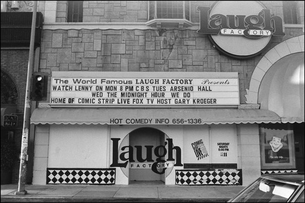
Across the street at 8001 Sunset, a Spanish colonial revival commercial complex (Norstrom & Anderson, 1930) exemplifies stasis and permanence in the arterial landscape, despite the obvious changes on the building’s facade. A two-part commercial block, elaborated with distinct corner towers, this structure originally contained nine retail spaces, with parking in the rear and a signage superstructure that was present from the beginning. As street-level occupancy changed, the signs became more elaborate and so did the storefront cladding. By 1973, the modernizations obscured the original decorative grilles as longtime tenants like Greenblatt’s Deli (ca. 1939) and Ah Fong’s Cantonese Foods (1950) asserted commercial individuality (fig. 19.15). Modernizations continued in 1979, when Greenblatt’s moved two doors down, adding brick, wood, and stained glass to an already variegated facade, and the Laugh Factory moved in to anchor the corner. By 1990, the latter had expanded into Ah Fong’s storefront, eventually painting over the moon-gate entrance and installing the Laugh Factory’s logo in its place (fig. 19.16). Doctrinaire preservationists might scoff at the facade’s haphazard eclecticism, but 8001 Sunset remains formally intact, suggesting the continuing viability of this straightforward compositional type.

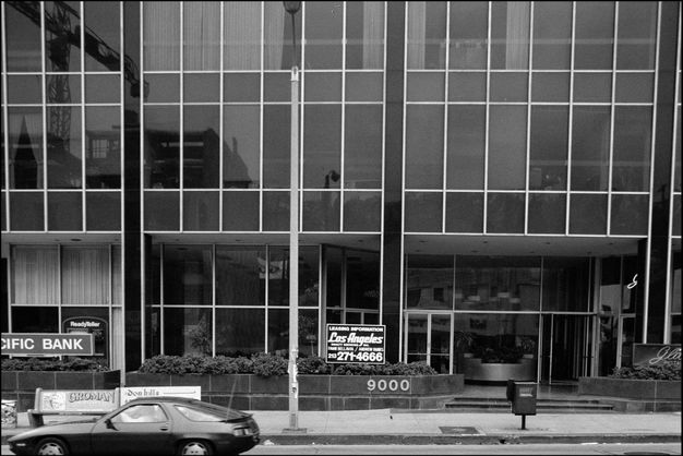
This, perhaps, is the most striking observation to emerge from a close examination of SoLA photos: the persistence into the twenty-first century of a commercial fabric defined principally by low-rise buildings (mostly one- and two-story structures), representing many of Longstreth’s basic types. Even today, mid- and high-rise edifices are rare on Sunset, accounting for four dozen buildings on the boulevard’s most intensely developed nine-mile stretch captured in the composites. The fifteen-story building (Sheldon L. Pollack & Associates, 1963) at 9000 Sunset remains the tallest on the Sunset Strip (fig. 19.17); at eighteen stories, the skyscraper (Honnold & Rex, 1963) at 6290 Sunset is one of the tallest on the entire boulevard—and the first constructed after the repeal in 1958 of the height limit that was in effect in Los Angeles beginning in 1904 (fig. 19.18). If Sunset has not become significantly taller since 1966, it has certainly become denser.

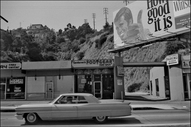
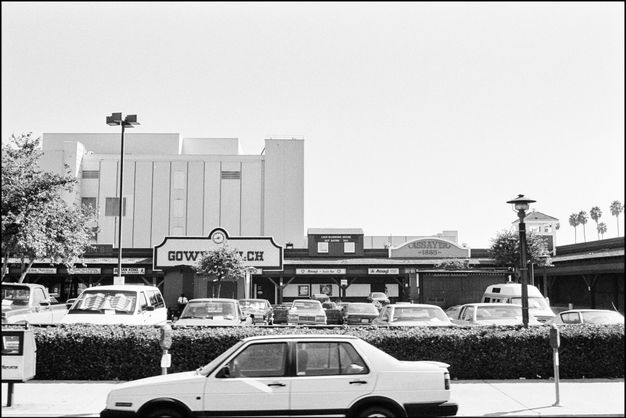
As evident in SoLA photos, Sunset’s increasing density is the result of a simple reality: over the past half century its parcels have been more intensively developed, but not in ways that generally violate the unwritten rules of its commercial grammar. In 1966, there were still empty lots on the Sunset Strip, and by the time these were developed, they followed existing patterns—even if their types were car-oriented variations on one-part blocks. At 8477–95 Sunset, for example, a single-story strip mall was erected in 1971 on a 35,000-square-foot trapezoidal lot snuggled against a rocky protrusion at the base of the foothills (fig. 19.19). It is set back far enough to allow for perpendicular parking and a driving lane in front, and it also has a rear parking lot. The same was true of empty lots away from the Strip: though 6106–24 Sunset in Hollywood was set further back from the roadway with parking in front, its type form was legible in relation to the boulevard and was likely enhanced by the Wild West theme of its decorated sheds (fig. 19.20). In a nod to the Westerns once produced in nearby movie studios, the Gower Gulch shopping plaza, completed in 1976, included oversized false fronts, wooden clapboards, “cowboys-and-Indians” visual motifs, and even a traveling medicine-show wagon on display out front— seemingly family-friendly visuals intended to counter the area’s sleazy reputation as the capital of the porn industry.
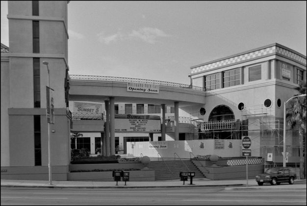
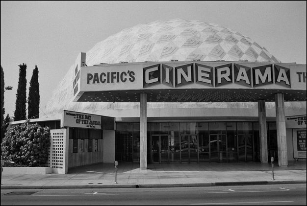
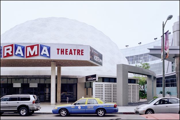
Another dimension of Sunset’s densification confirmed in SoLA images is the evolution of open space surrounding freestanding buildings. If the original structures challenged Longstreth’s prewar urban grammar, development during the last fifty years has pushed them toward conventional patterns. Other than the changing names of the movies on its marquee, the Cinerama Dome (Welton Becket & Associates, 1963) at 6360 Sunset seems like a static presence in SoLA photos, the earliest from 1973 (fig. 19.21). Images from subsequent years showing buildings adjacent to the dome, however, trace an arc of turn-of-the-century densification; for instance, between 2000 and 2002, Pacific Theatres renovated the dome and expanded into a neighboring parking lot to create a new retail and entertainment complex (with a seven-level parking garage). Part of this new complex, a low-rise glass-fronted block, wraps around the dome and stands at one story in order to align with the Cinerama Dome’s freestanding marquee, respecting Sunset’s street wall and gesturing to the surrounding context (fig. 19.22).

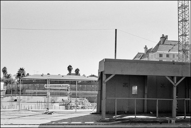
The Lytton Savings bank (Kurt Meyer, 1960) at 8150 Sunset did something similar. As is clear in images from 1966 on, this dynamic modernist variation of a two-part commercial block beckoned the attention of pedestrians and drivers alike (fig. 19.23). It had a concrete folded-plate roof producing a zigzagging silhouette that was balanced by a street-level glass facade with travertine cladding on top. The area around the bank was further developed to include a landscaped sidewalk apron, parking lot islands, outdoor sculpture, and a pedestrian plaza, transforming the building into an urban amenity along Sunset. The exterior remained intact as different banks moved in, the new signage and corporate color schemes recorded in SoLA photos. More emphatic change came to the site with the construction of a two-story mini-mall, completed by 1995, and set far back from Sunset, south and east of the bank building (fig. 19.24). When the pedestrian plaza was removed for additional parking, it made the bank appear even more strikingly monumental against a backdrop of mundane commercial space. In 2015, developers announced plans for a mixed-height, mix-used project designed by Frank Gehry to take the bank’s place, triggering a protracted preservation battle. That Gehry’s plans for the space embodied a dramatic intensification of Sunset’s density added to the swirling controversy until the project was canceled in 2023. But it was too late to save the building: the bank was demolished in 2021, and the entire site was cleared. Empty today, 8150 Sunset will undoubtedly be redeveloped. There is no sure way to predict what rules of urban grammar might apply to Sunset Boulevard in the future, but the past gives us a pretty good idea; and until then, as a historian, I will continue to town watch in the datascape, having learned from Scott Brown, Longstreth, and, of course, Ruscha about how to mine the SoLA Archive for evidence of stasis and change in arterial landscapes.
Notes
-
Richard Longstreth, “The Forgotten Arterial Landscape: Photographic Documentation of Commercial Development along Los Angeles Boulevards during the Interwar Years,” Journal of Urban History 23, no. 4 (1997): 438. ↩︎
-
A. D. Coleman, “I’m Not Really a Photographer,” New York Times, 10 September 1972. ↩︎
-
Ed Ruscha, quoted in One Pair of Eyes, season 1, episode 57, “Reyner Banham Loves Los Angeles,” directed by Julian Cooper, aired on 11 March 1972. ↩︎
-
Ed Ruscha, quoted in Calvin Tompkins, “Ed Ruscha’s L.A.,” New Yorker, 1 July 2013, 54. ↩︎
-
Robert Venturi and Denise Scott Brown, “A Significance for A&P Parking Lots, or Learning from Las Vegas,” Architectural Forum 128, no. 2 (1968): 36–42, 89, 91. ↩︎
-
See Britt Salvesen, “Seeing the Strip: The Photographic Archives of J. B. Jackson, Ed Ruscha, and Denise Scott Brown,” this volume. ↩︎
-
Denise Scott Brown, “On Pop Art, Permissiveness, and Planning,” Journal of the American Institute of Planners 35, no. 3 (1969): 185–86. ↩︎
-
Robert Venturi, Denise Scott Brown, and Steven Izenour, Learning from Las Vegas (Cambridge, MA: MIT Press, 1977), 9. See also Sylvia Lavin, “Positioning Denise Scott Brown: Los Angeles, 1965–1966,” e-flux Architecture, March 2022, https://www.e-flux.com/architecture/positions/443513/positioning-denise-scott-brown-los-angeles-1965-1966/. ↩︎
-
Richard Longstreth, Road Trip: Roadside America from Custard’s Last Stand to the Wigwam Restaurant (New York: Rizzoli, 2015), 12. See also Richard Longstreth, City Center to Regional Mall: Architecture, the Automobile, and Retailing in Los Angeles, 1920–1950 (Cambridge, MA: MIT Press, 1997); and Richard Longstreth, The Drive-In, the Supermarket, and the Transformation of Commercial Space in Los Angeles, 1914–1941 (Cambridge, MA: MIT Press, 2000). ↩︎
-
Nikolaus Pevsner, A History of Building Types (Princeton, NJ: Princeton University Press, 1976), 272. ↩︎
-
Chester H. Liebs, Main Street to Miracle Mile: American Roadside Architecture (Boston: Little, Brown, 1985). ↩︎
-
Richard Longstreth, The Buildings of Main Street: A Guide to American Commercial Architecture (Washington, DC: Preservation Press, 1987), 16. ↩︎
-
Longstreth, “Forgotten Arterial Landscape,” 437. ↩︎
-
Longstreth, City Center to Regional Mall, xvii. ↩︎
-
Longstreth, “Forgotten Arterial Landscape,” 437; and Scott Brown, “On Pop Art,” 186. ↩︎
-
Richard Longstreth, “Compositional Types in American Commercial Architecture,” Perspectives in Vernacular Architecture 2 (1986): 15. ↩︎
-
Longstreth, “Compositional Types,” 15–17. ↩︎
-
Venturi, Scott Brown, and Izenour, Learning from Las Vegas, 34–35. ↩︎
-
Longstreth, “Forgotten Arterial Landscape,” 438. ↩︎
-
Venturi, Scott Brown, and Izenour, Learning from Las Vegas, 34–35. ↩︎
-
Longstreth, “Forgotten Arterial Landscape,” 455. ↩︎
-
Scott Brown, “On Pop Art,” 186. ↩︎
-
Longstreth, “Compositional Types,” 3. ↩︎
-
Rob Walker, “Ruscha vs. Street View,” Design Observer, 8 August 2011, https://designobserver.com/feature/ruscha-vs-street-view/29318/. ↩︎
-
“12 Sunsets: Exploring Ed Ruscha’s Archive,” Getty, https://12sunsets.getty.edu. Always intended to be a limited-term application, the website for “12 Sunsets” will not be maintained. A video capturing some of its capabilities can be found here: https://vimeo.com/946364401/ba0b654c0d. ↩︎
-
Thomas Escobar, “Google Maps 101: How Imagery Powers Our Map,” 13 December 2019, https://blog.google/products/maps/google-maps-101-how-imagery-powers-our-map/. ↩︎
-
Nikhil Naik et al., “Computer Vision Uncovers Predictors of Physical Urban Change,” Proceedings of the National Academy of Sciences, 6 July 2017, https://doi.org/10.1073/pnas.1619003114. See also Ella Comberg, “Unreal City: Google Street View Photography Revisited,” Avery Review 51 (2021), https://averyreview.com/issues/51/unreal-city. ↩︎
-
Ed Ruscha, Production notebook, 1973–1990, sheet 3, Edward Ruscha Photographs of Sunset Boulevard and Hollywood Boulevard 1965–2000, box 7, 2012.R.1, Getty Research Institute, Los Angeles. ↩︎
-
Ruscha, Production notebook, sheet 3. ↩︎
-
Ruscha, Production notebook, sheet 11. ↩︎
-
Light-blue squares identified whole or partial sky, while pale-yellow squares indicated non-sky. ↩︎
-
Per GSV, picnic tables and umbrellas replaced the parking spaces sometime after May 2019, likely in response to the COVID-19 pandemic. ↩︎
-
Reyner Banham, Los Angeles: The Architecture of Four Ecologies (New York: Penguin, 1971), 118. ↩︎
-
The Sunset Boulevard shoots are from 1973, 1974, 1985, 1990, 1995, 1997, and 2007. Because Every Building on the Sunset Strip is limited to the 1.6 miles of the Sunset Strip, these images from 1966 are not included in the composite photographs. ↩︎
-
John Coplans, “Concerning Various Small Fires: An Interview with Edward Ruscha,” Artforum 3, no. 5 (1965): 25. ↩︎
-
For examples of Banham using Ruscha’s photos as evidence, see Banham, Architecture of Four Ecologies, 58, 85, 118, 251. ↩︎
-
Banham, Architecture of Four Ecologies, 236. See also the English translation of Anton Wagner, Los Angeles: The Development, Life, and Structure of the City of Two Million in Southern California, ed. Edward Dimendberg, trans. Timothy Grundy (Los Angeles: Getty Research Institute, 2022). ↩︎
-
Reyner Banham, “Encounter with Sunset Boulevard,” Listener 80 (22 August 1968), 235–36. ↩︎
-
Banham, Architecture of Four Ecologies, 247, 23. ↩︎
-
The bulk of the Whittington’s photos and documents are held in the Dick Whittington Photography Collection, 1924–1987, at the University of Southern California. Only a small portion of the images and inventories have been digitized. See https://digitallibrary.usc.edu/archive/Dick-Whittington-Photography-Collection--1924-1987-2A3BF1NOTQ.html. ↩︎