For most of its young history, Los Angeles has been a city of surface par excellence. While natural features determined the sites for many of the area’s initial settlements, the modern city we know today emerged from an abstract order imposed after its incorporation in 1850. For nearly a decade afterward, surveyors laid out street grids like lace tablecloths upon the alluvial plain, transforming geology into geography and nature into property. A low-profile continuum of single-family houses and clusters of commercial lots slowly filled in the grid. The implicit promise of this landscape—access to home ownership, gainful employment, and even self-reinvention, all in a benign climate—hushed any outcries against the city’s unconventional morphology.
With the automobile’s arrival in the early twentieth century, planners accommodated further expansion by adding boulevards and, later, freeways. In 1971, Reyner Banham wrote, “A city seventy miles square but rarely seventy years deep . . . Los Angeles is instant architecture in an instant townscape. Most of its buildings are the first and only structures on their particular parcels of land.”1 Whatever the city lacked in the vertical dimension of accrued time, it made up for with its excess horizontal extensions of space—space, it seemed, for opportunity, drawing thousands of in-migrants each year.
By the mid-1970s, however, this unique imbalance between the city’s spatial and temporal attributes underwent significant recalibration. Challenges to endless lateral growth started to surface. The time “before” gained currency: before Hollywood left Hollywood, before the freeways were no longer free, and before unrest, walkouts, and protests became the toll of the city’s exclusions. Postmodernists had replaced the modernists, and new coalitions had formed between preservationists and community activists to protect sites from the wrecking balls of the now well-lubricated “growth machine.”2 New developments soon sat next to saved relics. Fragments of outmoded transportation provided visual evidence of a recent past that many had already begun to forget.3
This essay examines Ed Ruscha’s Streets of Los Angeles (SoLA) project as one avenue for reading these shifts in the city’s real and perceived morphology. The project’s archive both documents the city’s history and represents an artist’s take on a much-mythologized city. Additionally, its development parallels major milestones in the urban planning of Los Angeles from 1965 to today. Ruscha photographed more than one hundred streets over nearly six decades, including Sunset Boulevard, Hollywood Boulevard, and Melrose Avenue, with an initial emphasis on their spatial horizontality; however, his repeat shoots would come to expose their diachronic layers—an effect further amplified through an interactive website, “12 Sunsets: Exploring Ed Ruscha’s Archive,” created by Getty.4 At every stage of his career, Ruscha’s work writ large has operated with a both/and rather than an either/or sensibility, often balancing nostalgic warmth with a cooler sense of the factual here and now. This essay argues that the artist’s SoLA Archive likewise establishes a similar tension between space and time, or geography and history—ultimately reinforcing the laterally organized, car-oriented metropolis of early Los Angeles while subverting Banham’s myth of the city as an ever-renewable surface.
A Certain Sense of Belatedness
The Los Angeles that Ruscha first experienced was not the postwar consumer-oriented city with which he has often been linked, but a city rooted in a mythical time of “before.” From his first childhood visits in the late 1940s, Ruscha fondly recalls a city that “threw romance in my face.”5 The glamour, the sunsets, the cars, and even the boring buildings decked with dazzling signs fired an imagination already primed by movies, glossy advertisements, and colorful news stories from his Oklahoma boyhood.6 This was the city built before the freeways, one that grew from a central core developed near the Los Angeles River, surrounded by various unincorporated zones—including the Sunset Strip, a notorious refuge for gangsters and movie stars.
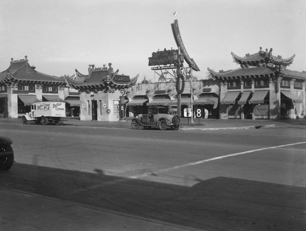
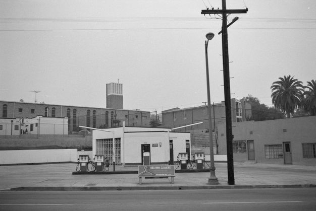
That early city already showed elements that would continue to fascinate Ruscha: streets dotted with new forms of vernacular architecture combining fantasy and convenience, such as the Mandarin Market (Henry L. Gogerty, 1929) (fig. 16.1).7 “Dotted,” in fact, accurately describes the punctuation effect of such buildings, given the discontinuities and gaps in the urban fabric. Despite the fact that the city used 5.8 percent of its land for commercial real estate during the late 1920s, 13.4 percent was zoned for it.8 At the time, the city did not need that much retail street frontage to serve its population (just as it doesn’t now). Yet speculators found they could make more money trading on the potential of that land through upzoning, rather than developing it with a particular function in mind.9 Large portions of the boulevards would thus remain undeveloped for a good part of the century.
Eventually, certain prewar characteristics—the nostalgic glow of old Hollywood, the proliferation of perfunctory buildings with interesting signs, and scattered empty lots on major thoroughfares—would become central elements in Ruscha’s work. Together, they helped establish a visual vocabulary for an “authentic” Los Angeles, an idealized state before, as Douglas R. Suisman wrote, “firmness gave way to flow” with the arrival of freeways and everything that accompanied them.10
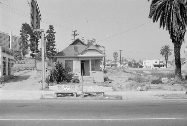
When Ruscha returned to attend college in 1956, the city had changed noticeably, with evidence of wholesale demolition littering every vista.11 New highway construction took the highest toll, razing the residential areas surrounding a new civic center in downtown L.A., the historic districts of Hollywood, the working-class immigrant enclaves of Boyle Heights, and the affluent Black neighborhoods of West Adams’s Sugar Hill district. To appease complaints, officials urged Angelenos to see their city not as “a finished landscape, but an embryo of future greatness,” as David Lowenthal wrote; its stretches of wasteland and building detritus signaled a future perpetually under development (fig. 16.2).12
Ruscha has recalled a certain sense of “belatedness” while navigating the city during those initial years.13 In truth, the planning for this postwar Los Angeles had started long before.14 Significant milestones included the Major Traffic Street Plan (1924) by Frederick Law Olmsted Jr., Harland Bartholomew, and Charles Henry Cheney; the Automobile Club of Southern California’s Traffic Survey (1937); the completion of the Arroyo Seco Parkway (1939–40); the Collier-Burns Act (1947) to pay for new highway construction; the creation of the Community Redevelopment Agency (1947) to oversee property acquisition; and the Federal-Aid Highway Act (1956) that funded the interstate highway system.
With the arrival of freeways, everything moved outward from downtown, bringing about the construction of new shopping malls (Baldwin-Crenshaw Center, 1947), residential communities (Lakewood, 1954), and amusement parks (Disneyland, 1955). The effects were felt quickly. The population of downtown L.A. decreased by 20 percent between 1941 and 1955, and so did much of its relative property value.15 As traditional boulevards lost their patronage, the footprint of Pacific Electric, the city’s long-standing railway system, shrank considerably. To combat these trends, downtown leaders invented new tax-increment financing to fund several urban renewal plans, and the Hollywood Chamber of Commerce, along with its Hollywood Improvement Association, created the Hollywood Walk of Fame in 1955 to increase tourism.16
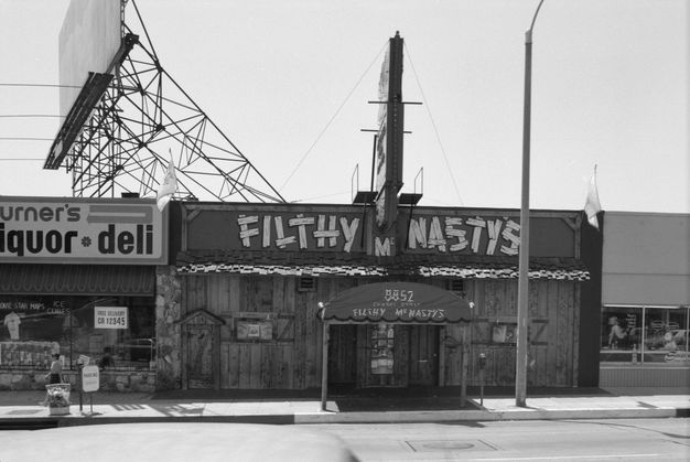
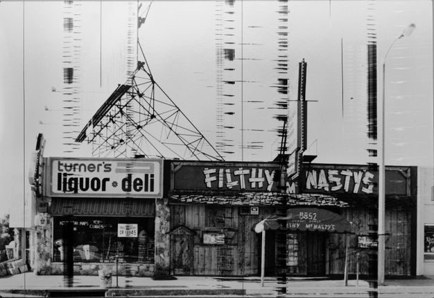
A near two million people moved to the L.A. metropolitan area between the time Ruscha first visited the area as a child and the time he graduated from Chouinard Art Institute and started his career.17 Streets continued to fill with gas stations and supermarkets adorned with colorful signs, but other new kinds of buildings serving the expanding consumer economy also popped up. These included hundreds of dingbat-style apartment buildings with names that evoked faraway places, such as the Tiki Tabu and the Algiers, and car-oriented food establishments, like Bob’s Big Boy in Burbank (Wayne McAllister, 1949), the McDonald’s hamburger stand in Downey (Stanley C. Meston, 1953), and Ships Coffee Shop in Westwood (Martin Stern Jr., 1958). Norms restaurant on La Cienega Boulevard (Louis Armet and Eldon Davis, 1957) would appear in Ruscha’s painting Norm’s, La Cienega, on Fire as early as 1964, and the Tiki Tabu and the Algiers were in his first L.A.-focused photography book, Some Los Angeles Apartments (1965) (fig. 16.3).
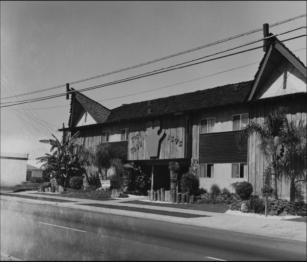
Image as Information, City as Sign
In addition to Some Los Angeles Apartments, several other of his artist books produced between 1962 and 1978 would take on Los Angeles as their subject. These visual recordings of the city remain as noteworthy for what they omit as for what they include. To begin with, they capture a relatively limited geography—focusing mainly on the city’s perfunctory buildings with interesting signs, empty plots of land, palm trees, swimming pools, and parking lots. Despite his love of automobiles, fascination with history, and interest in material Americana, Ruscha never focused on freeways, chose not to document the destruction of districts like that of Bunker Hill, and rarely sought to capture the spirit of the rapidly expanding suburbs, as many other photographers did during this era.18 Instead, Ruscha’s initial explorations during this time focused on the street level of urban thoroughfares, where commercial interests most directly shaped the city’s ubiquitous spatial form. In several, pages would be left blank, contents randomly ordered, and titles based on phonic rhyme.19 While a few of his artist books would attend to craft, the L.A.-oriented books were, like the city, purposefully “industrial.”20
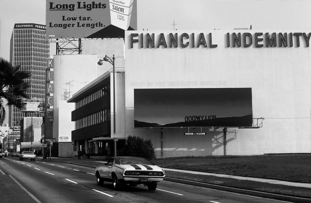
Pushing past traditional notions of authorship, he often had members of his studio take the actual photographs. This echoed the practices of paid-for-hire commercial photographers working around Los Angeles during the first half of the twentieth century. Companies such as the “Dick” Whittington Studio amassed thousands of images, and their clients included commercial entities like insurance companies, car manufacturers, and department stores.21 They did not aim to produce authored photographs but rather a field of reproducible images that would eventually appear downstream in calendars, postcards, accident reports, and newspapers, among other things.22 Like Whittington’s studio, Ruscha and his team captured images that translated, as Dave Hickey has suggested, the “noise” of the city into information—images that could be easily circulated and that would provide fertile source material for artmaking (figs. 16.4, 16.5).23
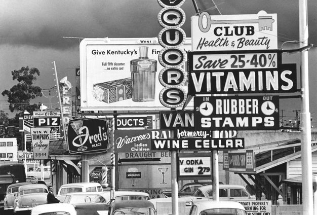
No street in Los Angeles during the 1960s better captured that fluid relationship between noise and information than the portion of Sunset Boulevard called the Sunset Strip. Located just up the street from Ferus Gallery (1957–66), this zone connecting Beverly Hills to Hollywood offered a cacophony of signage competing for attention. Once home to speakeasies, casinos, and nightclubs, the street now housed offbeat bookstores, bars, music venues, and health food stores, all part of L.A.’s growing counterculture. Ruscha’s artist book Every Building on the Sunset Strip (1966) inaugurated the SoLA project and established the core aesthetic principles for all its future shoots. Each sequence of frames helped organize information of the streetscape—such as numbers, lengths, heights, and details—into a single artifact, something between a surveyor’s record and an autopsy report.
By focusing on a landscape defined by lowbrow commercial architecture, Ruscha inserted himself into a long-standing conversation about the potential aesthetic and even the ideological value of the American vernacular landscape. Such discussions had originated in the nineteenth century but had recently come back into currency, ranging from the critical Peter Blake to the affirming Robert Venturi; both deployed photographs of “ugly America” to highlight a landscape meriting deeper attention (fig. 16.6).24 Less concerned with the aesthetics of what Venturi and Denise Scott Brown termed ducks or decorated sheds, the urban theorists Kevin Lynch and Jane Jacobs defended some visual aspects of prewar commercial vernacular architecture while criticizing how contemporary urban renewal had abandoned the traditional street.25
In concert with these thinkers, Ruscha helped loosen the stranglehold of high corporate modernism in contemporary architectural discourse.26 Los Angeles in the early 1960s witnessed several large, high-profile civic projects, such as the Dorothy Chandler Pavilion (Welton Becket, 1962), the Los Angeles County Museum of Art (LACMA; William Pereira, 1965) , and the Century City master plan (Becket, 1966–69). Rather than stitching these works into the city’s street-and-boulevard system, the architects aimed to replace roads with multifunctional modernist plinths. For Ruscha, such developments paradoxically signaled not rejuvenation but eventual decay: “Anything that was worth looking at seemed to be erased, and something came along to replace it that was repulsive.”27
In this context, the data of the Every Building photographs acquire new importance, and the shoots seem to make a case for the street’s historical value, a lowbrow, disorderly yet distinctly American morphology.28 The flatness of the black-and-white format highlights the importance of signage in the architectural vernacular, echoed in hundreds of western townscapes. This type of both/and sensibility, advocated by postmodern architects such as Venturi, appeared as a means of muting the either/or ideology of modernism—art and architecture considered either old and outdated or new and modern.29 As Jaleh Mansoor has argued, Every Building reveals a paradoxical tension in Ruscha’s work between “an exuberant affirmation of and resistance to a new consumer culture.”30
This focus on the commercial strip as a space of cultural value should complicate the common perception of Ruscha’s work as politically neutral—as often is the case with conceptual work of the period—or entirely disconnected from contemporary social conflict. The late 1960s and early 1970s witnessed unprecedented protests in the streets of Los Angeles, including the Watts uprising of 1965, demonstrations against a law-enforcement crackdown on the Strip in 1966, and the East L.A. walkouts led by Chicano high-school students in 1968. There is perhaps something radical in Ruscha’s interrogation of the street at this juncture, a space at once under increasing surveillance and reclaimed in very public struggles.31
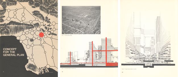
In addition to the plinth projects mentioned above, several major streets transitioned into pedestrian-only zones, such as the Third Street Promenade (1965) in Santa Monica and the Golden Mall (1967) in Burbank. Meanwhile, between 1964 and 1972, city planners developed L.A.’s first General Plan to manage future growth in population, traffic, and commercial development (fig. 16.7).32 Eventually from that effort, the Centers Concept strategy emerged, reimagining the city as a series of concentrated, fully interiorized retail centers connected through mass transit and surrounded by a sea of single-family homes.33 This vision for new Los Angeles would reduce the street to an efficient transit corridor, one that would no longer accommodate casual public gatherings or, for that matter, defiant youth protests.
After the passage of the Immigration and Nationality Act of 1965, previously low immigration numbers increased, and existing fissures over resources between the suburbs and the cities, as well as between white communities and people of color, generated even stronger forms of spatial division. As new freeways allowed suburbanites to avoid certain Los Angeles neighborhoods altogether, and new publicly approved legislation reversed progress toward desegregation (such as Article 34 and Proposition 14), any celebration of the urban street became legible as a subtle form of resistance.34
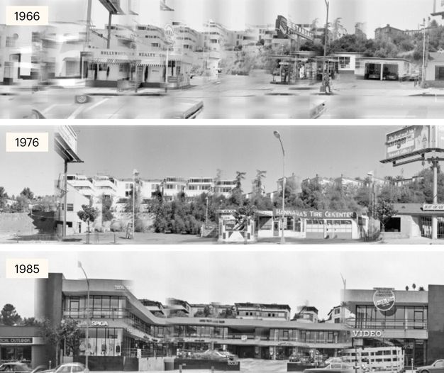
In the decade following the release of Every Building, Ruscha and his team would go on to shoot Hollywood Boulevard, the Pacific Coast Highway, Santa Monica Boulevard, and Melrose Avenue. They would also conduct additional shoots of Sunset, gathering material for yet-to-be-defined projects and, perhaps most importantly for Ruscha, to “nail down and capture” the city before it disappeared.35 If one compares the Sunset photographic footage from 1966 to that of 1976 (using the digital interface of “12 Sunsets”), one can now trace the loss of well-known venues from the 1960s, such as the nightclubs Pandora’s Box and Sea Witch, and see when other iconic establishments made their debut, such as Tower Records (1971) and the Roxy Theatre (1973). More subtly, one might discover that following the OPEC oil embargo of 1973, the number of gas stations along the Strip fell from ten to six—making room for mini-malls that began to populate the city in the next decade (fig. 16.8).36
This constant turnover lured investors seeking a quick profit; it also attracted Banham, whose model of the instant city would have such a strong influence on late-modernist discourse about Los Angeles. Banham appropriated works from several artists, photographers, and architects, but he saw special validation in Ruscha’s early images of L.A.’s car-centric geography. As the next section will show, however, Ruscha’s work ultimately proved less settled on the consequences of later twentieth-century urbanism than Banham had projected.37 Just as urban developments in the succeeding decades would come to complicate the instant city thesis, so would the documentary shifts in Ruscha’s SoLA Archive.
After Sunset
In Los Angeles: The Architecture of Four Ecologies (1971) and the BBC-produced TV documentary “Reyner Banham Loves Los Angeles” (1972), Banham positions Ruscha as someone in tune with a new type of sensibility toward image, place, and meaning. His book includes many photographs by Ruscha of empty parking lots; in the film, he interviews the artist in the lot of one of the last Tiny Naylor’s drive-in restaurants, located just east of the Strip. Both book and film conclude by drawing on Ruscha’s sunset trope: the book uses his silk-screen print Hollywood (1968) as its final image, and the documentary ends with a drive down Sunset in the last light of day. This metaphor embodies all that fascinated Banham about Los Angeles: a constantly evolving and ephemeral architecture, and a city of instants and disappearances, where “the best of it doesn’t last long.”38
Yet Banham’s assumed kinship with Ruscha appeared somewhat overdetermined even at the time. In the film interview, for instance, Ruscha gives somewhat circumspect answers and implies a continued sense of belatedness when faced with the relocation of favored midcentury landmarks.39 For that matter, Banham’s take on Los Angeles seems more belated than prescient, corresponding more to what the city had been than to what it was becoming. Projects such as the Convention Center (Charles Luckman, 1971), Pacific Design Center (Cesar Pelli, 1975), Bonaventure Hotel (John Portman, 1976), and Beverly Center (Becket, 1982) appeared soon after the book’s publication, readying Los Angeles for a global age—one less dependent on filling stations along intercontinental highways and more reliant on air travel from Los Angeles International Airport.
Starting in the early 1970s, new financial and political pressures began to inflect Banham’s midcentury Los Angeles. In a historic election in 1973, Tom Bradley replaced the three-term mayor Sam Yorty.40 Although annexation and suburbanization had left Los Angeles cash poor, it remained rich in land.41 After the financial crisis of 1973, mayors across the US, including Bradley, sought to attract new sources of capital by trading on the future value of the city’s properties to pay for current growth (echoing decision-making from the 1920s). By the mid-1970s, “the whole of downtown Los Angeles was declared a redevelopment area,” as Meredith Drake Reitan and Tridib Banerjee have noted.42 Fearing a negative impact on the downtown business core, the commercial elite resisted the dispersal of high-density developments across the L.A. basin, as the Center Concept had advocated. But they did believe that the plan’s complete separation of pedestrians from the street would “enhance the convenience, safety, and pleasantness of the core.”43
No longer a city of traditional retail-oriented streets, this new L.A., according to Manuel Castells, generated a new typology of spaces and a hierarchical, dynamic network of “flows”: “flows of capital, labor, elements of production, commodities, information, decisions, and signals.”44 Visionary plans to build elevated pedestrian walkways between high-rises to connect the fragmenting sectors of downtown L.A. did not come to pass, leaving pedestrians to negotiate the empty streets and even emptier passages from fortress to fortress.45 Not only did signs on buildings become smaller and less interesting but the experience of the city shrank as well (fig. 16.9).
Yet amid this development push, the planned demolition of a significant L.A. landmark prompted a public outcry, in turn producing a tectonic shift in the collective understanding of the city’s space and history. The proposed destruction of the Los Angeles Central Library (Bertram Grosvenor Goodhue, 1926) to make way for a large-scale office space in 1978 became the first real challenge to Banham’s instant city. For city planners and eager developers, the library—a mere fifty years old—had been rendered unnecessary following suburbanization and was now nothing more than an outdated firetrap. For others, it remained a major civic institution steeped in collective history that needed restoration, not destruction. The battle to save it gave birth to a full-fledged cultural-preservation movement, culminating in the creation of the Los Angeles Conservancy that same year.
The successful campaign to save the library sent a clear message: no more treatment of the city as a frictionless surface primed for continual redevelopment.46 From then on, conservationists routinely organized to preserve other prewar buildings; they also protected the city’s more ephemeral postwar infrastructure, including signage such as the Felix the Cat sign (Wayne E. Heath, 1958) that marked the city’s oldest existing car dealership. Ruscha added his own ambiguous commentary with his Back of Hollywood (1977), a billboard painting showing a reverse image of the Hollywood Sign at sunset that was temporarily installed in a parking lot on Wilshire Boulevard across from LACMA (fig. 16.10). Coinciding with a star-studded campaign to restore the Hollywood Sign, the billboard indirectly addressed the forward- and backward-looking aspects of contemporary L.A. It also offered a playful reversal of his screen print Hollywood (1968), which portrays the front of the sign at dusk—the image that concludes Banham’s book. Here, the sunset no longer serves as an object lesson of the instant city; instead, it cues the curtain call between dramatic acts.
By the end of the 1970s, postmodern sensibilities—mashing up past and present, near and far, high and low—entered the mainstream in architecture, art, and film in ways Banham would never endorse. Dolores Hayden challenged his claim that L.A. lacked any depth of history by retelling the stories of “invisible Angelenos” who had long resided in the basin.47 Through major projects such as the Loyola Law School campus (1978–) and the Santa Monica Place shopping mall (1980), Frank Gehry brought the long-standing vernacular sensibilities of the city’s street architecture front and center. Ridley Scott’s Blade Runner (1982), set in a futuristic Los Angeles, privileged a worn-out photograph as proof of “authentic” memory.48 If many art practices during the midcentury had actively imagined the future, those of the 1980s worked to legitimize the past, however imperfectly remembered.49
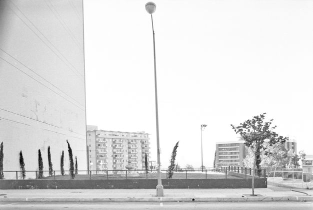
Just as the city began to reclaim its multiethnic history while hosting the Summer Olympics in 1984, the two most prominent streets in the SoLA Archive quickly gained vintage status: that same year the Sunset Strip shed its unincorporated status by joining the newly formed city of West Hollywood, while Hollywood Boulevard became a historic district in 1985.50 The latter soon began a forty-year “revitalization” as part of the city’s multibillion-dollar Hollywood Redevelopment Project.51 As Hollywood readied for its expensive facelift, Ruscha left his nearby studio on Western Avenue, a space he had occupied since 1965, and moved to Venice to accommodate the production of bigger work. Interestingly, he also picked his camera up again after a hiatus in street shooting from 1976 to 1985, capturing Sunset at least eight more times over the next fifteen years (fig. 16.11).
In 1989, Ruscha began reprinting photos from the 1960s and 1970s as stand-alone silver gelatin prints.52 By this time, new photographers had emerged who were documenting many of the same landscapes; but when the city erupted during the Rodney King riots in 1992, Ruscha’s images offered one of the best measures of how much Los Angeles had changed and how much it remained the same, socially and spatially.53 The act of reprinting images helped keep nostalgic impulses in check by destabilizing any sense of what might constitute the good old days. Starting in 1995, he went on to reprint other images from the SoLA Archive (figs. 16.12, 16.13).54 His more legible surface manipulations in these images point to a new interest in what we might call the ontology of film emulsion in its ability to tell time.
All these reprintings, including the production of a second SoLA book, would mark a distinct shift in the evolution of the archive—one that permitted more (ac)cumulative, but not definitive, interpretations of the city’s contested spaces. This both/and aspect of the project, as well as its open-ended quality, is critical for the archive’s forthcoming digital assemblage.
Anticipating the Archive
In 2002, early in his catalogue raisonné project with the master printer Gerhard Steidl, Ruscha suggested rephotographing Hollywood Boulevard.55 This resulted in his second SoLA book, THEN & NOW: Hollywood Boulevard, 1973–2004 (2005), which pairs photos from his first shoot of the boulevard in 1973 with those taken some thirty years later.56 In contrast to Every Building, this book more explicitly foregrounds the role of time relative to urban space and the city, placing the black-and-white images from the earlier shoot above the more recent color photos.
Any viewer familiar with Ruscha’s earlier artist books might find the aesthetics of this new volume unnerving, almost uncharacteristic of Ruscha, as the first shoot’s coolness overwhelms the second’s vivid coloration. Beyond the overt differences, however, what becomes striking is how the new volume attains both a sense of the passage of time and a record of how much has stayed the same; it captures the same features of L.A. streets that Ruscha fell in love with in the early 1950s. Matt Reynolds has suggested that any initial melancholy gives way to an equally strong sense of eerie repetition. As with the multiple shoots of Sunset Boulevard, the particular character of Hollywood Boulevard emerges with reiterations and retentions from a time before now, despite decades of redevelopment.57 In this sense, the contrast between the two sets of images ultimately pushes against the production of nostalgia and instead positions them as an indirect critique of the ways we (mistakenly) remember.
Following the completion of THEN & NOW, Ruscha and his team have continued to photograph the streets of Los Angeles at a pace far exceeding the first four decades of this project. In 2011, as Ruscha again moved his studio from Venice to a new facility in Culver City, the Getty Research Institute (GRI) acquired the SoLA Archive. Ruscha’s team continues to shoot the city’s thoroughfares, much as they did in 1966; Ruscha still stresses that his process remains purposefully egalitarian and unemotional: “Everything gets judiciously photographed, not just the interesting parts of it but everything.”58
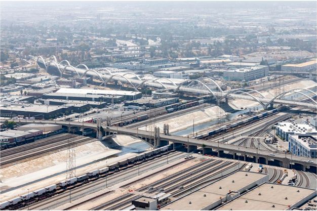
This all-inclusive impulse is perhaps the most enduring legacy of the SoLA endeavor. Ruscha may have stopped making artist books from the SoLA material for now, but the city goes on developing horizontal sites, from the One Santa Fe apartment complex to the Sixth Street Viaduct. (fig. 16.14) As the artist has noted, the SoLA project’s real value lies in capturing not what we already know as important but what we might encounter prosaically every day: “the curbs and the drainage channels and power poles and everything else—municipal concrete—that makes the whole study worthwhile.”59 In 1966, Ruscha saw Sunset Boulevard as “a 22-mile-long canvas, with an evolving history. . . . It had fluid motion, fluid stories, one long horizontal ribbon,” all of it asking to be documented.60
Despite the hundreds of thousands of Ruscha images now in the GRI’s holdings, the archive can never reach “actual size” relative to the city itself.61 Ruscha has only captured a minute portion of Los Angeles, and Getty has only digitized a relatively small fraction of that. Meanwhile, new photographers from an even broader range of Los Angeles geographies will continue to grapple with the horizontal ribbons marking the landscape, bringing their own perspectives. It will become essential to make room for these alternative imaginaries, as Getty has already begun to do.62
Ruscha once characterized the city of Los Angeles as a place where “everything hangs together; nothing fits.”63 This description matches the simultaneously incomplete and expansive realities of the city and archive. The brief overview here of Los Angeles’ planning history during the creation of the archive should alert us to the disjunctions in both. To my mind, the empty pages and out-of-order images of Ruscha’s books from the 1960s should help us anticipate the type of archive or database the SoLA project could become. Resembling Los Angeles’ first streets with their purposefully empty spaces, laid out to spur engagement and development, the open-platform armature of this growing digital archive holds the promise of inclusivity, dialogue, and further expansion.
Notes
I would like to thank Mark Shiel and Alyce Mahon for their early collaboration; Suzanne M. Noruschat and Alan Jutzi for their assistance with navigating the University of Southern California’s Dick Whittington Photography Collection, 1924–1987; and Adriana Romero and Leila Whittemore for their keen edits.
-
Reyner Banham, Los Angeles: The Architecture of Four Ecologies (Berkeley: University of California Press, 2009 [1971]), 21. ↩︎
-
Harvey Molotch, “The City as a Growth Machine: Toward a Political Economy of Place,” American Journal of Sociology 82, no. 2 (1976): 309–32. ↩︎
-
Norman Klein, The History of Forgetting: Los Angeles and the Erasure of Memory (London: Verso), 1997. ↩︎
-
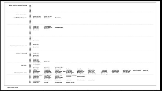
“12 Sunsets: Exploring Ed Ruscha’s Archive,” Getty, https://12sunsets.getty.edu. Always intended to be a limited-term application, the website for “12 Sunsets” will not be maintained. A video capturing some of its capabilities can be found here: https://vimeo.com/946364401/ba0b654c0d. Before 2019, Ruscha shot Sunset Boulevard at least twenty times; Hollywood Boulevard, roughly six; Melrose Avenue and Santa Monica Boulevard, four; Pacific Coast Highway, three; and Olympic Boulevard, Wilshire Boulevard, Beverly Boulevard, Pico Boulevard, Venice Boulevard, Fountain Avenue, and Franklin Avenue, twice. ↩︎
-
Edward Ruscha, “Ed Ruscha Oral History Interview,” interview by Rani Singh and Andrew Perchuk, 2011, video, 18:23:35, http://hdl.handle.net/10020/2012ia115av. See also Colleen Terry’s selected chronology in Karin Breuer et al., Ed Ruscha and the Great American West (Oakland: University of California Press, 2016), 193. ↩︎
-
Ruscha, interview by Singh and Perchuk. ↩︎
-
See Richard Longstreth, The Drive-in, the Supermarket, and the Transformation of Commercial Space in Los Angeles, 1914–1941 (Cambridge, MA: MIT Press, 1999), xv, 3–10. By 1936, it became known as the Hollywood Ranch Market, which Ruscha remembers seeing during his trips to Los Angeles as a child. Ed Ruscha, personal communication with author, April 2022. ↩︎
-
Andrew H. Whittemore, “Zoning Los Angeles: A Brief History of Four Regimes,” Planning Perspectives 27, no. 3 (2012): 396. ↩︎
-
Whittemore, “Zoning Los Angeles,” 393–415. Whittemore suggests property values could increase as much as 300 percent on land upzoned to commercial use. ↩︎
-
Douglas R. Suisman, Los Angeles Boulevard: Eight X-Rays of the Body Public (Novato: ORO, 2014 [1989]), 64. ↩︎
-
Martin Gayford, “Ed Ruscha: Interview,” Telegraph, 25 September 2009. Here Ruscha remembers his eyes stinging from the smog. ↩︎
-
David Lowenthal, “The American Scene,” Geographical Review 58, no. 1 (1968): 76. ↩︎
-
Sebastian Smee, “Ed Ruscha’s Stunning Sunset Strip Art Project Lets You Tour Its Full Length, East to West—and Back in Time,” Washington Post, 9 January 2021, E.1, https://www.washingtonpost.com/entertainment/museums/ed-ruscha-sunset-strip-getty/2021/01/07/5c14e6ba-4f89-11eb-bda4-615aaefd0555_story.html. ↩︎
-
This era parallels Ruscha’s pre-Los Angeles life, as he was born in 1937 and arrived in L.A. in 1956. ↩︎
-
William Fulton, The Reluctant Metropolis: The Politics of Urban Growth in Los Angeles (Baltimore: John Hopkins University Press, 2001), 136. See also Meredith Drake Reitan and Tridib Banerjee, “Kevin Lynch in Los Angeles: Reflections of Planning, Politics, and Participation,” Journal of the American Planning Association 84, no. 3–4 (2018): 221–24. ↩︎
-
In 1956, the historic height limit for new development in downtown Los Angeles was repealed, allowing structures to exceed the height of city hall. ↩︎
-
See U.S. Bureau of the Census, A Statistical Abstract of the United States, 79th ed. (Washington, DC: U.S. Government Printing Office, 1958), 15. In 1940, the total population of Los Angeles-Long Beach region was 2,916,403; in 1950, 4,367,911. See U.S. Bureau of the Census, A Statistical Abstract of the United States, 95th ed. (Washington, DC: U.S. Government Printing Office, 1974), 22. In 1960, the total population of the same area was 6,039,000; in 1970, it was approximately 7,042,000 (rounded up to the one thousandth). ↩︎
-
Images documenting these other L.A. landscapes might include Ansel Adams, Interchange, Los Angeles Freeway (1967); Arnold Hylen, The Brousseau Mansion (1960); and Harry Adams, Street View, Los Angeles (1968). ↩︎
-
Examples of books composed with blank pages include: Various Small Fires and Milk (1964), Real Estate Opportunities (1970), and A Few Palm Trees (1971). See also Jaleh Mansoor, “Ed Ruscha’s ‘One-Way Street,’” October 111 (Winter 2005): 127–42. Mansoor briefly examines the aesthetic and cultural “value” of empty sites. ↩︎
-
Ed Ruscha, quoted in Clive Phillpot, “Sixteen Books and Then Some,” in Edward Ruscha: Editions, 1959–1999; Catalogue Raisonné, ed. Siri Engberg and Clive Phillpot, vol. 2 (Minneapolis: Walker Art Center, 1999), 59. ↩︎
-
For a history of the studio, see Bill Bradley, Commercial Los Angeles 1925–1947: Photographs from the “Dick” Whittington Studio (Glendale: Interurban, 1981). ↩︎
-
See Virginia Heckert, Ed Ruscha and Some Los Angeles Apartments, exh. cat. (Los Angeles: J. Paul Getty Museum, 2013), 13–14. Ruscha states that he would have simply bought images to make his early books, but the ones he wanted did not exist, so he had to create them himself. ↩︎
-
Dave Hickey, “Wacky Molière Lines: A Listener’s Guide to Ed-werd Rew-shay,” Parkett 18 (1988): 29. ↩︎
-
Peter Blake, God’s Own Junkyard: The Planned Deterioration of America’s Landscape (New York: Holt, Rinehart, & Winston, 1964); and Robert Venturi, Complexity and Contradiction in Architecture (New York: Museum of Modern Art, 1966). See also Gabrielle Esperdy, “Ugly America,” Places Journal, November 2014, https://doi.org/10.22269/141120. ↩︎
-
Kevin Lynch, The Image of the City (Cambridge, MA: MIT Press, 1960); and Jane Jacobs, The Death and Life of Great American Cities (New York: Random House, 1961). For more on ducks and decorated sheds, see Robert Venturi, Denise Scott Brown, and Steven Izenour, Learning from Las Vegas (Cambridge, MA: MIT Press, 2001 [1977]), 87–90. ↩︎
-
Just before the onset of this discourse around vernacular architecture, historian Esther McCoy published Five California Architects (New York: Reinhold, 1960), acting as a type of capstone celebration of the purer modernist tradition in Los Angeles architecture. ↩︎
-
M. H. Miller, “Ed Ruscha: He Up and Went Home,” New York Times, 15 January 2020, sec. AR, 16. ↩︎
-
J. B. Jackson, “The American Public Space,” National Affairs: The Public Interest 74 (1984): 52–65. ↩︎
-
Venturi, Complexity and Contradiction, 16. ↩︎
-
Mansoor, “Ed Ruscha’s ‘One-Way Street,’” 133. ↩︎
-
See also Benjamin H. D. Buchloh, “Conceptual Art 1962–1969: From the Aesthetic of Administration to the Critique of Institutions,” October 55 (1990): 105–43. ↩︎
-
See Concept Los Angeles: The Concept for the Los Angeles General Plan (Los Angeles: Department of City Planning, 1970, approved 1972). ↩︎
-
In 1967, the Department of City Planning, under the leadership of Calvin Hamilton, sought public input on the future direction of urban development, framing the choices around four alternative concepts: centers, dispersion, corridors, and low density. A Los Angeles that was multicentered and dispersed was the most popular. The Centers Concept was officially adopted as part of the General Plan in 1974. ↩︎
-
Article 34 (1950) gave taxpayers the right to reject low-income housing projects in their communities, while Proposition 14 (1964) sought to nullify the recently federally approved Rumford Fair Housing Act (1963), which outlawed racial discrimination in the selling or renting of real estate. A majority of voters initially approved both provisions. Proposition 14 was ruled unconstitutional in 1966, while Article 34 remains in place today. ↩︎
-
For the source of Ruscha’s “nail down and capture” quote, see Miller, “Ed Ruscha,” https://www.nytimes.com/2020/01/15/arts/design/ed-ruscha.html. For a discussion of Ruscha’s impulse to record the disappearing city, see Miller, “Ed Ruscha,” 16. ↩︎
-
Following the OPEC oil embargo, the number of gas stations in Los Angeles County dropped by 46 percent. See Mary Melton, “A Brief History of the Mini-Mall,” Los Angeles Times, 16 November 1997, 26. The number of banks decreased as well. See Deborah Vankin, “65,000 Photos of Sunset Boulevard: Take the Ultimate Road Trip with Ed Ruscha,” Los Angeles Times, 7 October 2020. ↩︎
-
Some architectural historians attributed Banham’s early technomodernist influences as complicating any appreciation of early postmodernism. See Anthony Vidler, “Aformal Affinities,” Artforum 39, no. 10 (2001): 141–49. Vidler suggests Banham similarly categorized Frank Gehry within the (optimistic) history of California modernism. ↩︎
-
See Cécile Whiting, Pop L.A.: Art and the City in the 1960s (Berkeley: University of California Press, 2006), 10–15. Whiting starts to tease out some distinctions in Ruscha’s influence on others such as Banham and Venturi. ↩︎
-
For instance, Tiny Naylor’s was closed in 1984 and demolished a year later. ↩︎
-
Fulton, Reluctant Metropolis, 135. ↩︎
-
Fulton, Reluctant Metropolis, 235. ↩︎
-
Reitan and Banerjee, “Kevin Lynch,” 218. ↩︎
-
From Concept Los Angeles, 14. ↩︎
-
Manuel Castells, The City and the Grassroots: A Cross-Cultural Theory of Urban Social Movements (Berkeley: University of California Press, 1984), 314, as cited in Dolores Hayden, The Power of Place: Urban Landscapes as Public History (Cambridge, MA: MIT Press, 1997), 42. Regarding what was called the “Haagenization” of public space, see Mike Davis, City of Quartz: Excavating the Future in Los Angeles (New York: Random House, 1990), 223–25. ↩︎
-
This system of elevated walkways was known as the Calvin S. Hamilton Pedway, and portions of it were built until the plan was ultimately abandoned. See the original report on this walkway, also known as the Los Angeles Downtown People Mover, which planned to connect the Convention Center to the Bonaventure and other downtown locations: “Los Angeles Downtown People Mover: Executive Summary,” April 1980, http://libraryarchives.metro.net/DPGTL/ladowntownpeoplemover/1980_ladpm_executive_summary.pdf. ↩︎
-
David Gebhard and Robert Winter published the first edition of their Guide to Architecture in Southern California in 1965 with LACMA. The authors reissued an expanded second edition in 1977 (Peregrine Smith), followed by editions in 1985, 1994, 2003 (Gibbs Smith), and 2018 (Angel City Press). ↩︎
-
She arrived in 1979. See Hayden, The Power of Place, 83–96. Hayden notes that only 2 percent of historical markers designated the history of 60 percent of the population, with the remaining 98 percent commemorating white American culture since the city’s settlement. ↩︎
-
David Harvey, The Condition of Postmodernity: An Enquiry into the Origin of Cultural Change (Oxford: Blackwell, 1990), 312. ↩︎
-
I am thinking here of Roland Barthes’s influential book, Camera Lucida: Reflections on Photography (New York: Hill & Wang, 1981). ↩︎
-
The Olympic Arts Festival coincided with the summer games and was followed three years later by the biennial Los Angeles Festival (1987–91). ↩︎
-
Matt Reynolds, “Landscape in Motion: Nostalgia and Urban Redevelopment in Ed Ruscha’s Then & Now: Hollywood Boulevard, 1973–2004,” Journal of Urban History 41, no. 6 (2015): 1052–72. ↩︎
-
For discussion of what Ruscha calls his “waste-and-retrieval” method of making art, see Sylvia Wolf, Ed Ruscha and Photography, exh. cat. (New York: Whitney Museum of American Art, 2004), 220. ↩︎
-
These photos arguably form a dialogue with those of other photographers from this era. See the following works: Catherine Opie, Untitled #2 (Mini-Malls) (1997); and Robbert Flick, LD SV970121 Alameda B (1997). ↩︎
-
Wolf, Ed Ruscha and Photography, 216. ↩︎
-
Engberg and Phillpot, Edward Ruscha: Editions, 1959–1999; Catalogue Raisonné, 2 vols. (Minneapolis: Walker Art Center, 1999). ↩︎
-
Wolf, Ed Ruscha and Photography, 261; and Ed Ruscha, THEN & NOW: Hollywood Boulevard, 1973–2004 (Göttingen: Stiedl, 2005). With regard to THEN & NOW’s presentation of one site at two different moments, Ruscha recalls how, during a postcollege visit to Toledo, Spain, he became fascinated with El Greco’s paintings of the city and began taking photographs from similar spots; he returned to this idea in the 1970s after discovering James Rodney Hastings and Raymond M. Turner’s study The Changing Mile: An Ecological Study of the Vegetation of Change with Time in the Lower Mile of an Arid and Semiarid Region (Tucson: University of Arizona Press, 1965). Ruscha, personal communication with author, April 2022. ↩︎
-
Reynolds, “Landscape in Motion,” 1063. ↩︎
-
Wolf, Ed Ruscha and Photography, 251. See also Jonathan Griffin, “From Ruscha with Love,” Apollo 174, no. 591 (2011): 64–65. ↩︎
-
Vankin, “65,000 Photos of Sunset Boulevard.” ↩︎
-
Vankin, “65,000 Photos of Sunset Boulevard.” ↩︎
-
Ken D. Allan, “Ed Ruscha, Pop Art, and Spectatorship in 1960s Los Angeles,” Art Bulletin 92, no. 3 (2010): 232–36. Throughout his career, Ruscha has played with the idea of scale, starting with his early painting Actual Size (1962). ↩︎
-
See, for instance, Guadalupe Rosales’s more personal photograph of the new Sixth Street Viaduct taken from East Los Angeles, included in the Whitney Biennial of 2022. The GRI has begun to address this relationship between the Ruscha collection and contemporary artists in their Imaginaries of L.A. conversation series: https://www.youtube.com/playlist?list=PLdcw4RhcVX8uQuYLoCn8HkA1pCCRQjkAo. ↩︎
-
Hickey, “Wacky Molière Lines,” 29. ↩︎