Among those whom [Reyner] Banham thanks in the prologue are . . . a collection of people whose in-city trips east of Main Street or south of Olympic could be counted on Mickey Mouse’s fingers.
—Peter Plagens
What the world knows as Sunset Boulevard used to be a dirt trail along the foothills of the Santa Monica Mountains that supported cultural exchange between the Chumash and Tongva peoples of pre-Hispanic California for thousands of years. Under Spanish colonization after 1781, that trail provided access to the Pacific Ocean for soldiers and missionaries. And during Mexico’s brief claim to the land, the route connected the sprawling ranchos of Los Feliz, San Vicente and Santa Monica, La Brea, and Las Cienegas. In those days, more livestock than people treaded that path.
Forty years after the US conquest of Mexico in the Mexican-American War (1846–48), that path became Sunset Boulevard; it was parceled according to the ideology of private property ownership and segmented for residential, commercial, and industrial uses. Beginning in the 1890s, Sunset was paved by local governments and adapted to successive patterns of transportation. Roughly between 1910 and 1950, streetcars ran along the eastern portions of the boulevard, through the communities of Hollywood, Silver Lake, and Echo Park. But they did not reach its western portions—Beverly Hills, Bel Air, Brentwood, and Pacific Palisades, where automobile ownership precluded the need or desire for accessible public transit.
The twentieth century enlarged the commercial portions of Sunset to serve the voracious appetite of the expanding film, radio, television, and recording industries. It supported a low-rise, automobile-friendly landscape of entertainment studios in addition to the many businesses and services that catered to the workers in these areas, such as restaurants, bars, hotels, parking lots, car washes, gas stations, and the like. A star of film and popular music, Sunset Boulevard earned renowned stature as the manufacturing center of fame and glamour. By 1960, it rivaled New York’s Madison Avenue as the seat of the US culture industry.
It is therefore not surprising that Sunset Boulevard is where Ed Ruscha began one aspect of his celebrated career as a Los Angeles artist, assembling vast and precise photo archives of select L.A. streets. Where else would a starstruck Midwesterner go upon arriving in Los Angeles of the 1960s? Sunset Boulevard made sense for a young sojourner steeped in a long-standing affection for Hollywood film, someone who had treaded the westward path of the Dust Bowl migration and embraced the mobility and freedom afforded by the city’s car culture. Thus, in 1965, Ruscha drove east on Sunset from the Pacific Coast Highway, took lots of pictures, and made a book. The rest is legend: his prolific output of paintings, prints, collages, drawings, photographs, books, films, and other media; his associations with pop and postpop art; and the ubiquitous presence of his work in the world’s most eminent galleries and museums. While many visual artists have made their name in Los Angeles, few have commanded the prestige, celebrity, and wealth that Ruscha has amassed since the 1960s.
In a moment of social upheaval and political ferment, Ruscha became well known in the bourgeoning L.A. art world through his prodigious output, status, and influence. It seems that in the late 1960s, Ruscha’s center of gravity, inspiration, or opportunity was at the vital corner of La Cienega and Sunset Boulevards, where Hollywood’s movers and shakers rubbed elbows with a new art cognoscenti that opened a hip strip of white-wall galleries. Pursuing these social connections while sporting good looks and some macho swagger, Ruscha produced art that was welcomed by cultural elites eager to assert their city as a new New York, a center of creative innovation bolstered by hot real estate and cool art.
His photobooks in particular, like Every Building on the Sunset Strip (1966), resonated within an intellectual revolution underway by the late 1960s. Ruscha’s photos fueled a revision of the car-oriented strip urbanism modeled by Los Angeles and Las Vegas and analyzed by the likes of Reyner Banham, Robert Venturi, Denise Scott Brown, Steven Izenour, and others, who validated consumer culture and its shaping of western landscapes.1 Their work is profiled elsewhere in this volume, but these scholars credited Ruscha for many of their insights. Banham, for example, borrowed some of Ruscha’s photographs to bolster his argument in Los Angeles: The Architecture of Four Ecologies (1971) and saluted the artist as the “local talent” who portrayed gas stations as monuments in their own right.2 Ruscha’s photographs of L.A.’s built environment also drew praise from Venturi, Scott Brown, and Izenour, who authored the influential study of strip architecture, Learning from Las Vegas (1972). Scott Brown in particular was a huge fan of Ruscha and frequently cited his work. She lauded the “deadpan” nature of his photographs (a since-frequent descriptor of Ruscha’s work) and argued that the “nonjudgmental” character of these images should be emulated by future generations of architects and planners. She appreciated the apparent neutrality of his visual compilation and the image’s ability to “speak for itself.”3
But the key question is whether Ruscha’s work can fairly be called “nonjudgmental.” Can one create a neutral, deadpan, or nonjudgmental portrait of a landscape shaped by bias, judgment, and prejudice over time? Sunset Boulevard, like all L.A. streets, follows a clear geography of racial and class disparities that took shape through public policy and private practice over the course of the twentieth century. In the 1910s and 1920s, the plotting of communities like Beverly Hills followed strict measures of racial exclusion through policies like zoning and through the efforts of white homeowners who formed associations and inserted clauses into property deeds to maintain the whiteness of their Sunset-adjacent neighborhoods.4
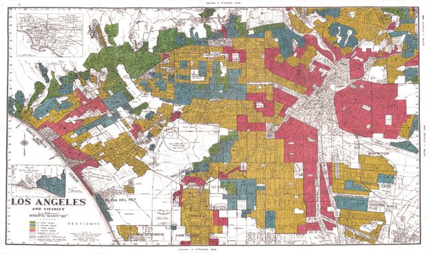
These efforts were undergirded by federal policies during the 1930s. Through the creation of the Home Owners’ Loan Corporation (HOLC) in 1933, a federal agency charged with restructuring the housing mortgage market during the slump of the Great Depression, the federal government enforced Sunset Boulevard as a boundary that demarcated race, wealth, and property on L.A.’s Westside. Through its extensive appraisals of urban neighborhoods between 1933 and 1940, HOLC established color-coded maps that identified the safest and riskiest areas for property investment. The four colors—green, blue, yellow, and red—corresponded primarily to the social composition of urban neighborhoods as well as to the uses and condition of buildings in the area. Green areas were generally wealthy—“homogenous” and “protected” by deed restrictions and safest for investment—while blue areas were considered less so, but still safe. Yellow areas were risky, but not as much as red or “redlined” areas, where “slum conditions” prevailed and where “negroes” were present. The area identified as Sunset Plaza, A-35 on the HOLC map (located between La Cienega Boulevard and Doheny Drive), is typical of many portions of Sunset Boulevard, characterized by the federal agency as “in demand,” where “deed restrictions protect against subversive racial influence.”5 In fact, from Hollywood west to Pacific Palisades, Sunset Boulevard lines a stretch of green neighborhoods, ones that were generally off-limits to African Americans and other racial groups (fig. 17.1).6
The postmodernist’s plea to learn from Las Vegas and Los Angeles—to accept their commercial strips nonjudgmentally, as a necessary break from the elitist orthodoxy of modernist urban design—requires one’s judgment to ignore the histories of redlining, zoning and deed restrictions, and property and homeowners’ associations. The combined forces of these acts built walls around much of Sunset, keeping white communities within its bounds while formally or informally excluding people of color. For instance, the Beverly Hills Hotel excluded Black guests for much of its history, including Paul R. Williams who designed the building; the original Warner Brothers studio would not hire any African American workers during the studio era of film production; and the city of West Hollywood denied the first application to open a Black nightclub on the Sunset Strip in 1985. These are just a few known examples of how Southern California’s legacy of white racism has structured the meaning and experience of Ruscha’s Sunset Boulevard.
Between the Pacific Ocean and downtown Los Angeles, Sunset crosses mostly green and blue neighborhoods on the HOLC map, and then it veers into yellow, even a little red, on its eastern flank. Further east, however, beyond the corner of Alameda Street and Sunset, where Ruscha took a U-turn to head back to the Westside, we venture into the red zone—a deep red zone “literally honeycombed with diverse and subversive racial elements.”7 Such was how the HOLC officially characterized the neighborhood of Boyle Heights.
Boyle Heights is absent from visual records and scholarly accounts of significant architecture in post–World War II Los Angeles. Banham ignored the area, as did Ruscha, David Hockney, Esther McCoy, David Gebhard, and Robert Winter for that matter; even Julius Shulman, who grew up in that neighborhood, moved to Laurel Canyon.8 Until only very recently, the area has been terra incognita for those who claim to have learned the lessons of urbanization in L.A., even though it is one of the oldest residential settlements in the city’s history, dating back to the nineteenth century. Before there was Beverly Hills, there was Boyle Heights.9
In significant ways, the HOLC created a blueprint for the upheaval unleashed on Boyle Heights in the mid-twentieth century. While the myth of midcentury Los Angeles—read the Westside—took shape through the praise heaped upon monumental gas stations, dingbats, Googie coffee shops, and Case Study Houses, the social profile of Boyle Heights underwent profound changes. What began as a racially and ethnically diverse working-class neighborhood in the early twentieth century had transitioned to a more monolithic concentration of Mexican American poverty saddled with toxic infrastructure and depleted by white flight. Through these forces, the barrio was born in L.A., becoming the nation’s largest by the 1970s.10
If Boyle Heights was the heart of East Los Angeles, Whittier Boulevard was its spine. A street roughly as old as Sunset, Whittier Boulevard similarly crosses city and county boundaries that produce uneven patterns of development along commercial and residential lines. Unlike Sunset, whose proximity to the entertainment industry brought affluence to the area, Whittier Boulevard did not enjoy this kind of wealth. In the middle-class communities of Montebello and Whittier, however, the boulevard exhibited some of the commercial vitality and architectural exuberance that captivated the mandarins of pop and modernism in L.A., but nothing compared to the glamourous glow of Sunset Boulevard.
Whittier Boulevard has anchored Latino Los Angeles for a long time, dating back a century, if not longer. Because of racial restrictions in many areas of L.A., along with a host of other factors, Mexicans have concentrated in East Los Angeles since the early twentieth century (and way before that as well), and Whittier Boulevard has been a main thoroughfare in the area. The street not only provided a focus for commercial and residential life but it also supported a vibrant public life that was pedestrian-friendly and allowed for socializing in markets, restaurants, theaters, burger stands, car washes, laundromats, sidewalks, and other commercial venues. This public life took shape against the odds of redlining and its consequences, including white flight, highway construction, racial segregation, and inferior public services.
Unlike Sunset, Whittier Boulevard has been truncated by the intersection of several major freeways, which converge along the western segment. Between the Los Angeles River and Soto Street, Whittier Boulevard tangles with the East Los Angeles interchange, where the 10, 60, 101, and 5 Freeways converge. Farther east, the boulevard bisects the 710 Freeway as it winds its way south toward the Port of Los Angeles. The communities aligned along the western portion of Whittier Boulevard were described as evidence of “slum conditions” in East Los Angeles by the HOLC survey form, which also included a prescription for “rehabilitation.” Because “slum conditions prevail,” the HOLC official noted that “the federal government . . . in conjunction with the city government [is] undertaking a slum clearance project . . . in the area.”11
That last sentence portended ominous consequences for the fate of Boyle Heights. During the postwar period, state and federal highway agencies worked in tandem with slum clearance efforts in cities throughout the nation. In many instances, alternative housing accommodations were not provided for families who were dislodged from what were deemed slums. Highway construction decimated about one-tenth of the housing stock in Boyle Heights alone, putting additional strain on the remaining housing supply.12 Like other redlined areas in US cities, Boyle Heights and the neighborhoods of East Los Angeles languished from lack of investment, accommodating the further influx of poor, working-class people of color, even as bulldozers and wrecking balls tore the land asunder. Between 1950 and 1970, three massive freeway interchanges were constructed where six major freeways converge in the area, defining the heart of the L.A. freeway system.
While the culture and landscape of the city’s Westside commanded the attention of artists, journalists, film directors, and rock stars, the material conditions of East Los Angeles neighborhoods fell further into disrepair and neglect. Nonetheless, the area supported a culturally vibrant public life based on family networks and workplace connections as well as on the bonds formed in schools, churches, restaurants, and markets. As immigration from Mexico surged in the latter decades of the twentieth century, Mexican immigrants joined preexisting generations of Mexican Americans, enhancing the vitality of Boyle Heights as a binational, bilingual cultural zone. By the late 1960s, this new community had replaced an ethnically, racially, linguistically, and religiously diverse working-class community, what once had been recognized as late as the mid-1950s as a “U.N. in Microcosm.”13
The diminished diversity of East Los Angeles and the expanding population of residents of Mexican descent made the area a frequent target for local law enforcement, whether by L.A. police officers or L.A. County sheriffs. As far back as 1943, for example, Chicano youth became suspect during the infamous so-called Zoot Suit riots. The Sixth Street Bridge across the L.A. River, where Whittier Boulevard begins to the west, became a stage for the unprovoked racial attacks on Chicano zoot-suiters by white servicemen. In the violent confrontation, law enforcement sided with the attackers, fixated on the zoot suit as evidence of criminality, and blamed the victims of a citywide racial assault. In the 1950s and 1960s, Whittier Boulevard became a popular strip for Chicano hot-rodders and drag racing, spurring confrontations with county sheriffs and L.A. police officers who patrolled the street and often closed it to discourage this activity.14
During the 1960s, a new generation of Mexican American activists—the Chicano generation—marched down Whittier Boulevard to protest the many forms of injustice that beleaguered their community. In the spring of 1968, thousands of students from multiple public high schools in East Los Angeles walked out of their classrooms to protest the prevalence of overcrowded classrooms, high dropout rates, and the lack of teachers and counselors of Mexican descent. The protesters marched along Whittier Boulevard to demonstrate that they were fed up with the segregated and inferior conditions of their public education, making the East L.A. walkouts the first battle cry of a politicized Chicano community.15
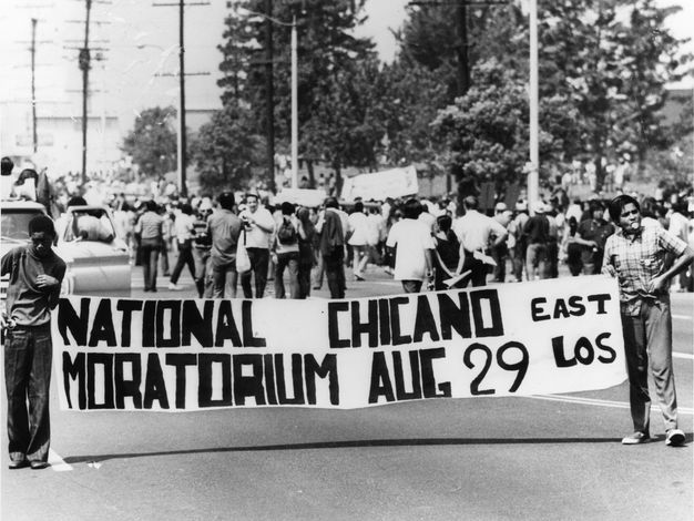
Whittier Boulevard was also the site of the National Chicano Moratorium in 1970, when twenty to twenty-five thousand people, mostly local families and children, took to the boulevard to peacefully protest the Vietnam War and the disproportionate number of Chicano youth killed in combat (fig. 17.2). With signs declaring “Chicano Power” and “Raza Si, Guerra No!,” protesters converged upon Laguna Park, which was under the county jurisdiction of Sheriff Peter J. Pitchess, who was convinced that Chicano activists in East L.A. were tied to communist Russia and advocated a hard line against Eastside protesters. Despite the peaceful nature of the protest, scores and eventually hundreds of cops and deputies in riot gear stormed into the park with batons to break up the crowds, beating people who intimated any signs of resistance. Chicano organizers who monitored the day’s events to ensure public safety and discourage nonpeaceful outbursts were beaten and arrested. Bystanders were attacked, as were local residents, including older men and women. Tear gas flooded a three-mile stretch of Whittier Boulevard, which essentially became a war zone.
Four people died at the hands of sheriffs during the melee, including Ruben Salazar, a Los Angeles Times journalist who investigated racism and corruption within local law enforcement agencies. Salazar died while seated at the Silver Dollar, a bar on Whittier Boulevard near Laguna Park. A sheriff, acting on unverified reports that two men with guns entered the bar, fired a tear gas canister into the Silver Dollar from the street. The projectile entered Salazar’s head from the left and came out on the right, killing him instantly. Hours before his death, Salazar confided to his associates that he believed he was a police target for his reporting, and that federal investigators had colluded with local law enforcement to infiltrate the Moratorium and create disruptions that justified severe police repression. Salazar’s warnings were ignored in official investigations of his death, but community members remain convinced of his assassination.
Other contemporary East Los Angeles artists contributed to the broader development of a street-based art that exposed the crisis of a barrio under siege. After the chaos of the walkouts and Moratorium, for example, Whittier Boulevard became a stage for the theatrical antics of the Chicano conceptual art group Asco, which is Spanish for “nausea.” Harry Gamboa Jr., Patssi Valdez, and Willie Herrón III—three Garfield High School students who participated in the walkouts—met in their senior year and soon joined Gronk (Glugio Nicandro) to forge Asco out of their common experiences as kids from the barrio. During the height of the Chicano movement, Asco created performance-based art rooted in humor and satire, staging tactical interventions and guerrilla practices that bore resemblance to Fluxus and Dada as well as Mexican art groups of the 1970s and 1980s called grupos and Mexican street performances known as merolicos. Asco used the familiar tactics of Chicano activism—street protests, graffiti, and leaflets—to articulate a political critique through performative art, grounded in public spaces like Whittier Boulevard.16
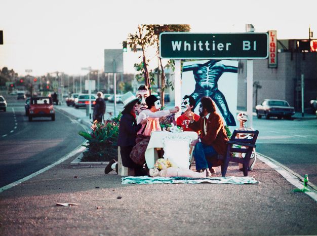
In its formative years during the early 1970s, Asco dedicated much of its work to reclaiming Whittier Boulevard in a moment of intense police repression. For months after the Moratorium, East L.A. had been under unofficial martial law, with parking bans, street closures, and police sweeps after 6 p.m. In the immediate aftermath of a curfew, Asco performed First Supper (After a Major Riot) (1974), in which they wore elaborate costumes and makeup to stage a formal dinner party on a traffic median of Whittier Boulevard at rush hour (fig. 17.3). Arousing curiosity from drivers passing by, this absurdist spectacle underscored Asco’s political claims to the boulevard. As Gronk recalled in a recent interview, “We all had ten cents in our pocket in case we had to make that phone call from jail.”17 Asco had begun its run on Whittier Boulevard in 1971 with what they called “walking murals” such as Stations of the Cross. In this performance, Gronk dressed as Pontius Pilate, blessing onlookers with popcorn, while Herrón led a procession down Whittier Boulevard as a calavera (skeleton)/Christ figure carrying a large cardboard cross. When the procession reached the entrance to a US Marines recruiting center, Gronk performed a ritual blessing and Herrón left the cross at the doorstep. This was followed by five minutes of silence to remember the Chicano lives lost in the Vietnam War. The following year, in response to the county’s cancellation of the annual Christmas parade along Whittier Boulevard, Asco reasserted its presence with Walking Mural—a “nonparade,” in the words of Gronk.18 With Valdez dressed as the “Virgin of Guadalupe in black,” Asco staged a silent procession with friends walking in solidarity.
Asco’s grounding in the streets of East L.A. marked a sharp contrast to the roving camera of Ruscha. The members of Asco put their bodies on the street, documented their presence, created spectacle, sparked attention, and used local signage, storefronts, and sidewalks as backdrops for their staged performances. In doing so, they boldly staked a claim on their local landscape to assert the beauty, dignity, and glamour of the Chicano barrio. Ruscha, by contrast, used an automobile to help him depict the fluidity of the L.A. street space, leaving out any traces of people and their place within it. Asco’s determination to reclaim East L.A. through street-based performance art reflected a willingness to take sides in the larger struggle between the law-and-order thrust of racist urban policies and the community-based aspirations of self-empowerment and self-determination. That struggle is wholly absent from Ruscha’s work, as it is largely absent from the streets of West Los Angeles, which remained untouched by the discriminatory impact of redlining, police surveillance, and highway construction.
The ephemeral nature of Asco’s street performances demanded a permanent visual record through film and photography. As a founding member, Gamboa brought his camera to Asco’s guerilla performances, documenting the group’s work with an archivist’s sense of dutiful preservation. Other barrio-bound Chicano photographers also captured Asco’s work, with an eye toward the urban context of Whittier Boulevard and its built environment. Elsa Flores, for instance, focused on the outpouring of creative work in East L.A., photographing Asco’s conceptual performances as well the work of other East L.A. Chicano artists like Frank Romero and Carlos Almaraz. After learning photography in the military while stationed in Japan, Oscar Castillo came back to East L.A. to create a visual record of Chicano culture and politics. His iconic images of Mexican Americans marching down Whittier Boulevard during the Chicano Moratorium have shaped the public’s memory of the event and solidified the stature of the boulevard as the cradle of the Chicano movement. Unlike Ruscha’s photographs of Sunset, however, Castillo’s portraits of Whittier Boulevard are packed with Mexican Americans of all ages who fashioned a distinctive Chicano identity in a time of urban upheaval and political unrest. Also, unlike Ruscha, Castillo, like his contemporaries in East L.A., did not win mainstream recognition for his work until only recently.
In addition to photography and performance art, East L.A. also sustained a growing corps of painters and muralists, who, like the members of Asco, fully immersed themselves in the politicized climate of the 1960s and 1970s. They also similarly pursued art making as a collaborative endeavor, forming art collectives that defied the traditional Euro-American emphasis on singular artistic genius (of straight white men). Ruscha was a collaborator, too; indeed, his Streets of Los Angeles project was more of a team effort than a one-man show. But, the general reception of his work—and the artistic milieu of West Los Angeles—emphasized the singular talent of an individual artist, not the efforts of artistic teams working collectively to help solve a community’s problems. East Los Angeles in the 1960s and 1970s cultivated a different art culture. Through student networks in art schools, county job-training programs, political groups dedicated to racial justice, and informal associations, Chicano and Chicana artists forged collectives as a deliberate strategy to resist the individualistic ethos of white Western society and bolster the shared ties of a community under siege.
Throughout the late 1960s and 1970s, several of these collectives took shape on the Eastside, including the Mechicano Art Center and the East Los Streetscapers. During its nine-year history, for example, Mechicano dedicated itself to the search for an art that heals the wounds inflicted by police repression and social injustice. Its founder, Victor Franco, was a community activist with significant ties to other community-based organizations. Although Mechicano initially debuted in a small storefront space on La Cienega Boulevard, high rents in the area forced Franco to relocate his gallery to the Eastside, where Chicano art was flourishing. With funding from the National Endowment for the Arts, he secured a space at 4030 Whittier Boulevard—an abandoned laundromat—to create a dynamic art center in East L.A. dedicated to promoting Chicano artists and their work. The East Los Streetscapers was formed by East L.A. natives David Botello and Wayne Healy in 1975. And like Mechicano, they brought Mexican muralism, which emphasized the history of Mexico’s pre-Hispanic civilizations, to the streets of East Los Angeles. For these artists who pioneered the Chicano mural movement, murals beautified a neighborhood decimated by highway construction and police brutality, and taught residents about their own history and community.19
Another pioneer of the Chicano mural movement was Judy Baca, born and raised in Pacoima, which became a satellite barrio in the San Fernando Valley by the 1970s. Straddling the Chicano and feminist movements of the early 1970s, Baca trained as a muralist under the tutelage of the renowned Mexican artist David Alfaro Siqueiros. Beginning around 1973, Baca began work on an ambitious project to paint a lengthy mural that would become known as The Great Wall of Los Angeles. This mural stretches more than half a mile across a concrete channel in the San Fernando Valley known as the Tujunga Wash, which replaced the Tujunga River when the US Army Corps of Engineers channelized the L.A. River and its tributaries as a means of flood control in the 1930s and 1940s. Such foreboding spaces present a challenge but also an opportunity for barrio artists like Judy Baca, who described The Great Wall as a tattoo on the scar of what used to be the L.A. River.20
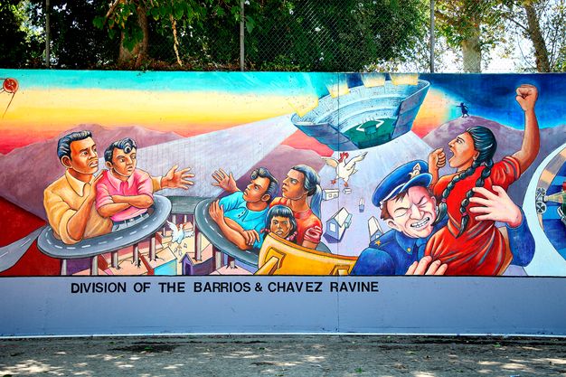
In the tradition of Mexican muralism, The Great Wall brings vitality to the lifeless expanses of concrete shaped by modernist interventions in the twentieth-century urban landscape. It documents an alternative people’s history of Los Angeles and California, with scenes that emphasize the experiences and perspectives of marginal social groups, including Indigenous peoples, women, immigrants, workers, Black Americans, and LGBTQ communities. Specifically, the mural conveys how Mexican American communities in East L.A. bore the brunt of highway construction in the 1950s and 1960s as well as the communal residue of suspicion and mistrust toward large-scale state interventions.21 In one panel portraying post–World War II L.A., a writhing, almost serpentine, freeway separates a Mexican American family and crashes upon the barrio landscape below. This scene is situated alongside the portrait of the Chavez Ravine, where Dodger Stadium collides into the remains of a Mexican American neighborhood amid great public controversy and community indignation (fig. 17.4).
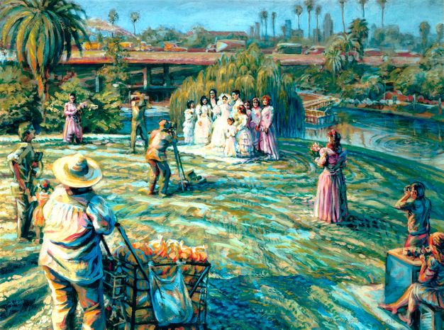
Like Baca, many Chicano artists had a score to settle with L.A.’s freeways. These artists witnessed the encroachment of freeway infrastructure upon their neighborhoods and turned to art to make sense of the upheaval in their midst. In their search for an art that recognized the Mexican American barrio as a landscape of beauty, vitality, violence, and injustice, these artists looked at freeways head on to capture this inherent paradox. For instance, the freeway figures prominently in canvas paintings by Botello, who, after his involvement in the East Los Streetscapers, returned to his original training as a painter to depict scenes of everyday life in the East L.A. barrio. In Wedding Photos–Hollenbeck Park (2004), the freeway lurks in the background of a wedding held at a public park, casting a long shadow over the neighborhood landscape (fig. 17.5).
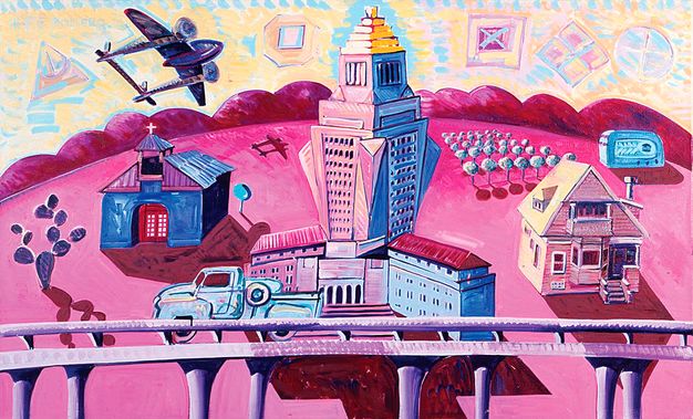
When the art collective Los Four disbanded in 1983, after the heyday of the Chicano movement, two of its founding members, Frank Romero and Carlos Almaraz, retreated to their studios to focus their attention on the dominant features of East L.A.’s landscape. Born in Boyle Heights in 1941, Romero relied on streetcars in his youth, but the invasion of freeways in his neighborhood in the 1950s and 1960s changed his perspective. In his studio, Romero began painting scenes of the East L.A. barrio, and the freeway figured prominently in his vision, as it did in the scenery of his community. That representational correspondence took a turn in the 1980s, when Romero began painting more abstract images of L.A. freeways and their sinuous forms. Such abstractions, as shown in his painting Pink Landscape (1984), however, were rooted in the massive concrete forms that dominate Boyle Heights today (fig. 17.6).
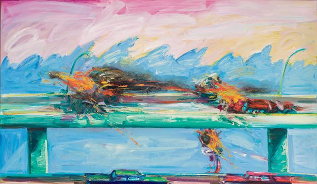
Almaraz earned acclaim for his paintings on canvas toward the end of his stint with Los Four, especially after his death from an AIDS-related illness in 1989. Among his last and most famous accomplishments were his car crash paintings. These paintings, including Crash in Phthalo Green (1984), convey explosive disasters on freeways, one driving catastrophe after another in abstract eruptions of fire, motion, and brilliant color (fig. 17.7). Almaraz’s studio was located on the southern edge of Echo Park Lake (a blank space on Ruscha’s mapping project of Sunset Boulevard), just north of the 101 Freeway. There, the artist found inspiration from the unique predicament of living between a “very serene lake” and “the Hollywood Freeway, which literally has crashes going on every few hours. . . . I used to wake up to the sound of metal crunching.”22
Though there are many buildings on Ruscha’s Sunset Strip, there are no freeways. In fact, if California’s Division of Highways had had its way, a freeway would have imposed itself directly into Ruscha’s line of sight. This would have been the Beverly Hills Freeway, or the 2, running from its northern terminus in La Cañada Flintridge, continuing through Glendale and into Echo Park, and finally sweeping westward across the Los Angeles Basin along Santa Monica Boulevard. The residents of Beverly Hills, however, said no to this plan. They organized powerful political opposition to this proposal, which was officially canceled in 1970. This is why the State Route 2 stops abruptly in Echo Park. The Beverly Hills Freeway was among several freeway plans for L.A.’s Westside, such as the expansion into freeways of Mulholland Drive, Malibu Canyon Road, and Topanga Canyon Road, all scrapped by hillside NIMBY forces.
These freeways would have made their way into Ruscha’s photographs or at the very least would have cast shadows on the landscapes he photographed. Opposition from wealthy, white Westside communities like Beverly Hills ensured their privilege to live in a freeway-free environment. The residents of Boyle Heights were not afforded such privilege, even though they, too, organized community opposition against highway construction. This points to another structural disparity that conditioned the production of art in L.A. during the 1960s. Like redlining, highway construction had drastically varying consequences for different neighborhoods within the same city, and it was all contingent on the social coordinates of race and class.
The streets of Los Angeles traverse diverse neighborhoods structured by broader disparities that took vivid shape in US cities throughout the decades following World War II. In the many concentrations of racial poverty in urban America—specifically, in disadvantaged neighborhoods wrought by private prejudice and discriminatory public policy—these disparities came to violent fruition in the mid-1960s, especially in L.A., where the deadliest, most destructive racial uprising exploded over the course of five days in early August 1965. Triggered by another outburst of white police abuse toward unarmed Black residents, upset onlookers set the streets of South Los Angeles—including Slauson Avenue, Manchester Avenue, Central Avenue, Crenshaw Boulevard, and Alameda Street, among others—on fire, leaving a wake of thirty-four people dead and hundreds of millions of dollars in property damage. The Watts uprising stunned the world and shattered the postwar myth of midcentury modernism authored by Banham, Ruscha, and others; it did not, however, extinguish the creative spark that ignited a flourishing of Black art in L.A. during the late 1960s and beyond. In the aftermath of the Watts uprising, a new corps of Black L.A. artists made beauty in the wake of destruction. Like Asco in creating First Supper (After a Major Riot), David Hammons, Senga Nengudi, John Outterbridge, Noah Purifoy, Betye Saar, Charles White, and other Black L.A. artists staked their creative claims upon the southern streets of a western city. They forged a new art that directly confronted the problems and possibilities of Black life in urban America and challenged the authority of an artistic status quo that elevated the work of white male artists in the apathetic age of pop.23
Unlike Sunset Boulevard, the streets of East and South Los Angeles cultivated very different communities of artistic expression, and they were just as focused as Ruscha on the immediate built environment. A key difference, however, was the degree of engagement with that landscape. While Ruscha labored to produce a dispassionate, distant, and “deadpan” portrait of every building on Westside streets, Black and Chicano artists immersed themselves in the streets of their L.A.: they got dirty sifting through the wreckage of urban unrest, they inhaled the exhaust of surrounding traffic, they lay their bodies on sidewalks and bus benches, they posed beneath freeways, they painted on buildings, and they took the occasional risk of arrest in their creative pursuits. Their immersion in the landscapes of the barrio and the ghetto was a brash but necessary political choice, an act of solidarity with community-based politics of liberatory justice that inspired a new generation of civic leadership. Thus, while Ed Ruscha burnished the myth of a star-studded street, these artists looked through clouds of smoke, tear gas, and smog to make art from their own streets, which were worlds apart but just miles away.
In L.A. during the 1960s and 1970s, the disparities among the city’s distinct art worlds came into sharp relief. In general, Black and Chicano artists created art not for art’s sake but for their communities’ demands for justice and empowerment. That doesn’t make their work any less artistic or less creative than the backslapping fraternity of La Cienega’s Gallery Row who indulged its aesthetic inclinations, unburdened by community expectations and political demands. In contrast to the work of Asco, Baca, Los Four, Purifoy, and Saar, for example, Ruscha’s Streets of Los Angeles photos convey a very western sense of freedom, akin to Frederick Jackson Turner’s ode to the democratizing spirit of the frontier, or Jack Kerouac’s restless urge in On the Road (1957). Getty’s digital assemblage of Ruscha’s photographs in “12 Sunsets: Exploring Ed Ruscha’s Archive” underscores this sense of freedom—the freedom to move, to roam, to drive, and to venture headlong into the glitzy mess of western streetscapes like Sunset Boulevard. In Ruscha’s photographs, viewers find a fluid urban landscape that glides seamlessly across the city’s Westside, a landscape with no barricades, no freeways, no curfews, and few shadows. Only against the backdrop of East and South Los Angeles can we understand this work as a function of racial, class, and gender privilege.
What would it look like to have created a similar photo-assembly of Whittier Boulevard or Central Avenue in the late 1960s? The linear expanse of storefront architecture and street signage would be interrupted by the expansive concrete walls of imposing freeways or the darkness of their shadows. There would be substantial voids of empty dead space in the ashen remnants of burned-down buildings, or abandoned storefronts that signaled the lack of commercial vitality. There would probably be signs of a greater police presence, an absence of banks and supermarkets, a greater frequency of liquor stores and check-cashing centers, and a dearth of billboards and restaurants. This was not Ruscha’s or Banham’s Los Angeles, but it was still Los Angeles, an unequal and undemocratic city whose portrait has been there all along for those paying attention.
Notes
Epigraph: Peter Plagens, “Los Angeles: The Ecology of Evil,” review of Los Angeles: The Architecture of Four Ecologies, by Reyner Banham, Artforum 11, no. 4 (1972): 70.
-
Reyner Banham, Los Angeles: The Architecture of Four Ecologies (New York: Harper & Row, 1971). While on the streets of East L.A., Ruscha no doubt passed or was passed by Banham, the British professor and architectural historian who relished L.A.’s car culture and sped across his favorite parts of the city in a convertible Mustang. With Los Angeles: The Architecture of Four Ecologies, Banham inserted Los Angeles into a revolutionary reappraisal of US urban life in the 1960s, accepting—some would say celebrating—Los Angeles as the paragon of a car-oriented consumer culture and strip-landscape design that relied on storefront signage to communicate the popular values of mobility, speed, convenience, and choice. ↩︎
-
Banham starred in a video companion piece to Los Angeles: The Architecture of Four Ecologies, in which he interviews Ruscha for his take on L.A. as a center of design innovations. See One Pair of Eyes, season 1, episode 57, “Reyner Banham Loves Los Angeles,” directed by Julian Cooper, aired on 11 March 1972. ↩︎
-
Denise Scott-Brown, “On Pop Art, Permissiveness, and Planning,” Journal of the American Institute of Planners 35, no. 3 (May 1969): 184–85. See also Alexandra Schwartz, Ed Ruscha’s Los Angeles (Cambridge, MA: MIT Press, 2010). ↩︎
-
Robert Fogelson, The Fragmented Metropolis: Los Angeles, 1850–1930 (Berkeley: University of California Press, 1993); and Marc A. Weiss, The Rise of the Community Builders: The American Real Estate Industry and Urban Land Planning (Washington, DC: Beard, 2002). ↩︎
-
Home Owners’ Loan Corporation (HOLC), Los Angeles City survey files, Record Group 195, 2 February 1939, Records of the Home Owners’ Loan Corporation, National Archives, Washington DC. ↩︎
-
Richard Rothstein, The Color of the Law: A Forgotten History of How Our Government Segregated America (New York: Liverlight, 2018); Ira Katznelson, When Affirmative Action Was White: An Untold History of Racial Inequality in Twentieth-Century America (New York: Liverlight, 2016); and Kenneth Jackson, “Race, Ethnicity, and Real Estate Appraisal: The Home Owners’ Loan Corporation and the Federal Housing Administration,” Journal of Urban History 6, no. 4 (1980): 419–52. ↩︎
-
HOLC, Los Angeles City survey files, Boyle Heights, 19 April 1939, Records of the Home Owners’ Loan Corporation, National Archives, Washington, DC. ↩︎
-
As a writer and scholar of architectural history, Ester McCoy singularly put Los Angeles on the map of American architecture as early as 1960 with the publication of Five California Architects (New York: Reinhold, 1960), the first work to bring attention to the designs of pioneer California modernists. She wrote frequently for the influential design magazine Arts & Architecture and authored subsequent books about Richard Neutra, Craig Ellwood, and Case Study Houses. Originally published in 1965, David Gebhard and Robert Winter, eds., An Architectural Guidebook to Los Angeles (Los Angeles: Angel City, 2018), is now in its sixth edition. ↩︎
-
Mariana Moglievich, “Monuments and Mediocrity: Landmarking Los Angeles,” Future Anterior 11, no. 1 (2014): 34–52. ↩︎
-
Ricardo Romo, East Los Angeles: History of a Barrio (Austin: University of Texas Press, 1983). ↩︎
-
HOLC, Los Angeles City survey files, Boyle Heights, 19 April 1939. ↩︎
-
Eric Avila, Popular Culture in the Age of White Flight (Berkeley: University of California Press, 2004), 55. ↩︎
-
Ralph Friedman, “U.N. in Microcosm: Boyle Heights; An Example of Democratic Progress,” Frontier: The Voice of the New West 6–7 (1955): 11–14. ↩︎
-
Luis Alvarez, The Power of the Zoot: Youth Culture and Resistance during World War II (Berkeley: University of California Press, 2009); and Anthony Macias, Mexican American Mojo: Popular Music, Dance and Urban Culture in Los Angeles, 1935–1968 (Durham, NC: Duke University Press, 2008). ↩︎
-
Andrea Muñoz, “Blowout! The Testimony of Mita Cuarón and the 1968 East Los Angeles Walkouts,” in Rewriting the Chicano Movement: New Histories of Mexican American Activism in the Civil Rights Era, ed. Ellen McCracken and Mario T. Garcia (Tucson: University of Arizona Press, 2021), 195. ↩︎
-
Rita Gonzales, Howard N. Fox, and Chon Noriega, Phantom Sightings: Art after the Chicano Movement, exh. cat. (Berkeley: University of California Press, 2008), 114–19. See also Rebecca Lowry, “Art against the World: Collaborative Antagonism in 1970s Los Angeles,” in Conflict, Identity, and Protest in American Art, ed. Miguel de Baca and Makeda Best (Newcastle upon Tyne: Cambridge Scholars, 2015), 121–40. ↩︎
-
Andrea K. Scott, “The Glam Politics of a Chicano Collective from East L.A.,” New Yorker, 16 September 2017, 36. ↩︎
-
Scott, “Glam Politics,” 39. ↩︎
-
Reina Alejandra Prado-Saldivar, “On Both Sides of the Los Angeles River: Mechicano Art Center,” in L.A. Xicano, ed. Chon A. Noriega, Terezita Romo, and Pilar Tompkins-Rivas (Los Angeles: UCLA Chicano Studies Research Center Press, 2011), 42. ↩︎
-
Judy Baca, “Painting in the River of Angels,” 11 March 2021, https://www.mellon.org/voices/painting-in-the-river-of-angels. ↩︎
-
In 1983, in preparation for the Summer Olympics the following year, the Los Angeles Olympics Organizing Committee commissioned Baca to take over a stretch of the 110 Freeway to paint Hitting the Wall: Women in the Marathon (1984). Baca painted this mural on the surface wall of the 3rd Street underpass of the 110 Freeway, the central corridor of L.A.’s sprawling freeway system. Working with at-risk youth from underprivileged neighborhoods, Baca painted a female marathon runner in the throes of victory as she breaks the tape of the finish line, lunging toward the viewer with her arms outstretched in triumph as sunlight floods the background scenery. As the runner crosses the finish line, she breaks through the wall, which crumbles into rubble at the foot of the mural. The mural therefore celebrates the victory of women (and the first Olympics that included women in the marathon event) at the same time that it disputes the sturdiness of the freeway. ↩︎
-
Eric Avila, The Folklore of the Freeway: Race and Revolt in the Modernist City (Minneapolis: University of Minnesota Press, 2014). ↩︎
-
Kellie Jones, ed., Now Dig This! Art & Black Los Angeles, 1960–1980, exh. cat. (Los Angeles: Hammer Museum, 2011); and Kelli Jones, South of Pico: African American Artists in Los Angeles in the 1960s and 1970s (Durham, NC: Duke University Press, 2017). ↩︎