With the elements of a survey identified during the planning process, the next step is to fully develop survey tools, methods, and procedures. This chapter assumes that a survey methodology will be designed in accordance with standards and guidelines identified during survey planning and will incorporate approaches that are:
-
Standards-based, to ensure consistency in resource identification, documentation, and evaluation
-
Relevant, to keep pace with current professional practices in the heritage field
-
Efficient, to use cost-effective and labor-saving tools and technologies to complete survey work on a prescribed schedule and on budget
-
Flexible, to allow for adjustments and refinements over the life of a survey to reflect lessons learned, changing priorities, and the evolving needs of the project
-
Reliable, to result in quality data and instill broad-based confidence in and support for the survey
Survey Recording and Documentation Standards
Public agencies of many national and regional (e.g., provincial or state) jurisdictions worldwide publish guidelines and associated instructional manuals for conducting heritage surveys that may be consulted to develop recording standards and procedures.1 Survey manuals generally cover all aspects of field work, research activities, and detailed documentation requirements and specifications (see, for example, Virginia Department of Historic Resources. 2017. Guidelines for Conducting Historic Resources Surveys in Virginia. Richmond: Virginia Department of Historic Resources. https://www.dhr.virginia.gov/wp-content/uploads/2018/06/SurveyManual_2017.pdf; Oregon State Historic Preservation Office. 2011. Guidelines for Historic Resource Surveys in Oregon. Salem: State Historic Preservation Office, Oregon Parks and Recreation Department. https://www.oregon.gov/oprd/OH/Documents/guidelines_for_historic_resource_surveys.pdf; Heritage Branch, Department of Environment and Heritage Protection. 2015. Carrying Out a Heritage Survey. Brisbane: State of Queensland. https://www.qld.gov.au/__data/assets/pdf_file/0033/66768/gl-heritage-survey.pdf).
Level of Detail and Documentation of the Survey
Heritage surveys can be designed to document resources at varying levels of detail. Influencing factors include survey goals, objectives, and outcomes, as well as project management considerations such as available time, personnel, and budget. The terms reconnaissance and intensive define two levels of survey work; both include fieldwork and research, but they differ in the level of effort required and the resulting documentation (Derry, Anne, H. Ward Jandl, Carol D. Shull, and Jan Thorman. 1985. National Register Bulletin 24: Guidelines for Local Surveys: A Basis for Preservation Planning. Revised by Patricia L. Parker. Washington, DC: National Register of Historic Places. https://www.nps.gov/subjects/nationalregister/upload/NRB24-Complete_Part1t.pdf; https://www.nps.gov/subjects/nationalregister/upload/NRB24-Complete_Part2.pdf).2
A reconnaissance survey is a cursory field inspection of an area to assess its general character and development patterns and to provide preliminary information about the location, distribution, and nature of heritage resources; it may also flag resources for further study. An intensive-level survey combines in-depth field inspections and research to thoroughly document important heritage resources in an area and to complete evaluations of significance. An intensive-level survey and documentation provides the greatest amount of information and is the most useful for heritage inventories and management.
When the objective of a survey is to comprehensively document and evaluate heritage resources, reconnaissance and intensive approaches are typically applied sequentially. See chapter 10 for a discussion of how reconnaissance and intensive surveys were carried out for SurveyLA.
The following are suggestions for when it may be appropriate to use a reconnaissance-level approach:
-
When the objective of a survey is to collect information at the area scale rather than to record individual heritage resources. For example, a reconnaissance survey can provide information to identify and assess neighborhood character relating to overall patterns of development, land use, prevalent architectural styles, associated historical periods, and resource typologies. Such information can inform long-range or strategic planning initiatives to identify, preserve, and enhance the prevailing character of communities (Bertron, Cara, and Randall Mason. 2012. Character Study Project: Developing a New Type of Historic Resource Survey. Philadelphia: University of Pennsylvania School of Design. https://www.design.upenn.edu/sites/default/files/Character_Study_Project.pdf; Historic England. 2017b. Understanding Place: Historic Area Assessments. UK: Historic England. https://historicengland.org.uk/images-books/publications/understanding-place-historic-area-assessments/heag146-understanding-place-haa/).
-
When planned as a first phase of a long-term survey effort. For example, when financial resources for the survey are limited or are spread across a number of years to accommodate organizational budgets and grant cycles.
-
When there is an urgent need for rapid collection of information on a particular geographic area or resource typology due to circumstances such as natural disasters or development pressures.
-
When a geographic area has never before been surveyed and the nature of its heritage resources is unknown. In these instances, reconnaissance survey data can be used to develop a scope and plan for an intensive survey.
-
For archaeological surveys where there is no associated prior survey or excavation work.
Information Standards
As discussed in part I, many countries have official national heritage inventories that contain specific categories of information to be recorded for a variety of heritage resource types. These information categories also often apply to associated regional and local inventories and are typically used to guide information standards for heritage surveys, as detailed in relevant survey manuals.
In general, a comprehensive survey record, such as one completed for an intensive-level survey, will include information sufficient to map, classify, describe, and justify the significance of resource types ranging from individual buildings to urban districts to cultural or archaeological landscapes. Common categories of recorded information include resource name, location, typology, condition, description, important dates, development history, associated persons and events, associated historic contexts and themes, assessment of heritage significance, and photographs.
Survey recording standards may also include categories of information not required for an authoritative inventory but that help meet survey goals and objectives. For example, a survey may record known threats to a resource, historic photographs, and additional sources of information.
Other Recording Considerations
While the type, detail, and extent of survey documentation is generally established by official standards and guidelines, other decisions regarding what resources to record may be discretionary. Considerations may relate to the proposed uses of data, scale of the survey, available budget, and survey schedule. For example, will only resources that meet survey evaluation criteria of significance be recorded to help stay on budget and schedule? Or is there a need to record all heritage resources in an area, including those that do not meet significance criteria, to provide comprehensive information for land use planning and decision-making? Do designated or listed resources need to be resurveyed or their information updated where there have been substantial changes in the state of the environment?
For SurveyLA, decisions regarding what to record were largely based on the challenges of managing a large-scale citywide survey and considerations relating to project schedule, timeframe, and budget. While the entire city was included in reconnaissance-level surveys, only those resources that appeared to meet evaluation or eligibility criteria based on field observations, research, and public input were fully documented. Resources recorded as significant in previous surveys were either resurveyed or updated as needed, while designated resources were not.3
Importantly, establishing clear parameters for what heritage resources will be recorded will help manage public expectations regarding what is included in survey results and what will be added to or amended in the associated inventory.
Assessment Criteria
Instructions and guidelines for assessing heritage significance have been published by many agencies. For example, in the United States, the National Park Service has published the Secretary of the Interior’s Guidelines for Evaluation (National Park Service. 1983. Archaeology and Historic Preservation: Secretary of the Interior’s Standards and Guidelines. Washington, DC: U.S. Department of the Interior. https://www.nps.gov/subjects/historicpreservation/upload/standards-guidelines-archeology-historic-preservation.pdf) as well as the technical bulletin How to Apply the National Register Criteria for Evaluation (National Park Service. 1997a. How to Apply the National Register Criteria for Evaluation. Washington, DC: U.S. Department of the Interior. https://www.nps.gov/subjects/nationalregister/upload/NRB-15_web508.pdf). Other examples include guidelines published by the State of New South Wales (State of New South Wales and Department of Planning and Environment. 2023. Assessing Heritage Significance: Guidelines for Assessing Places and Objects Against the Heritage Council of NSW Criteria. Parramatta: Environment and Heritage Group, Department of Planning and Environment. https://www.environment.nsw.gov.au/-/media/OEH/Corporate-Site/Documents/Heritage/assessing-heritage-significance-guidelines-assessing-places-objects-against-criteria-230167.pdf) and the Department of Natural Resources and Environment Tasmania (Department of Natural Resources and Environment Tasmania. 2021. Assessing Historic Heritage Significance, version 6. https://heritage.tas.gov.au/Documents/Assessing Historic Heritage Significance.pdf). The following are considerations for using evaluation criteria for heritage surveys:
-
Surveys can evaluate resources under one or more evaluation systems. SurveyLA, for example, assessed significance under local, state, and national criteria for evaluation. Doing so makes the inventory usable for a range of purposes, including compliance with state and national environmental review laws, designation under multiple programs, and resource eligibility for a range of financial and other incentive programs.
-
Where evaluation criteria do not exist for a local jurisdiction, relevant national, regional, or state criteria may be adopted or adapted for use.
-
In some cases, well-defined guidelines for how criteria are applied may need to be developed or updated to comply with current heritage conservation practices, such as to address intangible heritage.
-
A new or revised evaluation system should be open to public input and consideration and will need to be in place before any fieldwork commences. This process can take considerable time and effort, which should be accounted for in the overall project timeline and budget.
Further discussion of and recommendations for applying evaluation standards for surveys can be found in Making Assessments of Heritage Resource Significance in chapter 10.
Structuring Field Surveys
Survey methodology will include how field surveys will be organized, ordered, and completed. The grouping and sequencing of surveys can be based on priorities established for the survey, for example, to first survey geographic areas or heritage types that have never been surveyed or that are underrepresented in existing inventories. Priorities may also address urgent needs for up-to-date information, such as to identify important at-risk resource types, inform disaster preparedness and response efforts, or support planning initiatives that rely on survey results. A phased approach to completing field surveys may also be needed, particularly for those planned to be completed over a number of years, to accommodate cyclical funding for the project.
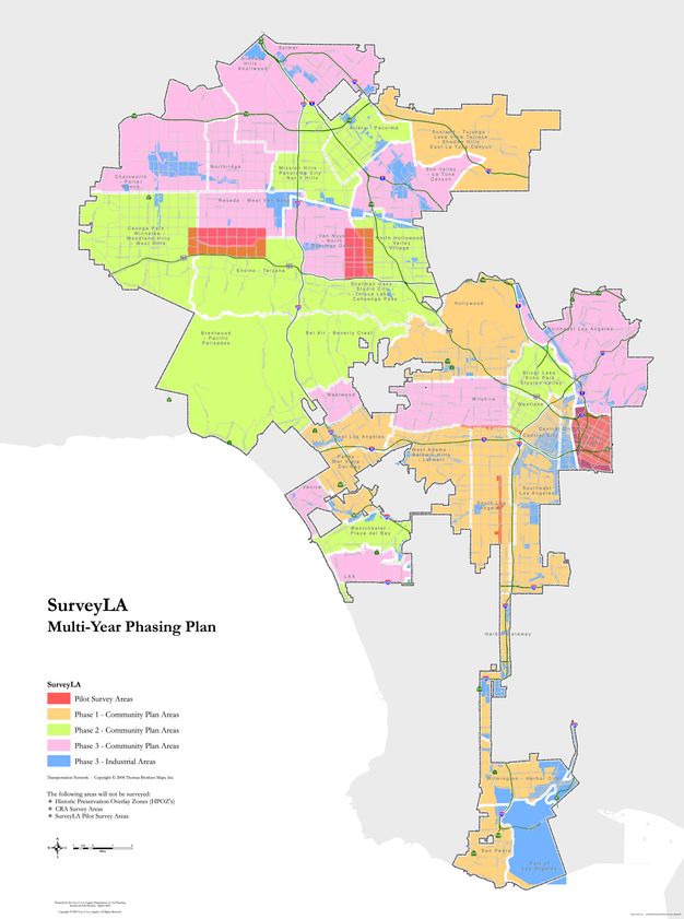
For SurveyLA, field surveys were organized into thirty-five geographic areas based on the long-established boundaries of Los Angeles’s community plan areas (fig. 8.1). These survey areas were further organized into ten groups, which were prioritized, sequenced, and phased to inform and coordinate with the city’s Community Plan Update program. (See also the SurveyLA Case Study section in chapter 10 to learn how this structure informed the community planning process.)
Designing Digital Surveys
A primary recommendation for a digital survey data collection system is that it be designed to collect data to be incorporated into a corresponding digital heritage inventory. As mentioned before, thought may need to be given first to whether the information system of the ongoing inventory should be modernized or upgraded, or even whether a new one needs to be created. The survey information system should temporarily store the records and evaluations of the same variety of heritage typologies to be included in the corresponding inventory, which may comprise individual buildings, structures, objects, cultural landscapes, archaeological sites, and intangible heritage.
For resources covering large areas with multiple associated features, such as a residential neighborhood, urban district, or grouping, the system should support the ability to assess and record all such features, their locations, and the relationships between them. The system should be capable of having its data structure expanded or revised as required, as long as those modifications do not create problems for incorporating collected data within the corresponding inventory system. Considerations for the capabilities of a survey information system should closely align with considerations for heritage inventories, as discussed in chapter 3.
Data Standards and Specifications
Survey data standards and specifications help ensure consistency in recording resources, that the data created is valid, and that it can be readily integrated with a corresponding heritage inventory (see Data Integration in chapter 11 for recommendations on the latter point). The following are key aspects to be addressed in such standards and specifications:
-
Controlled values and vocabularies. A key component of standards and specifications is controlled values and vocabularies, which use uniform concepts and terms to identify, categorize, describe, and evaluate heritage resources. These will align with those of the corresponding inventory and be in accordance with the standards and guidelines adopted for the survey. (See chapters 2 and 3 for more on these topics.)
-
Geospatial locations. The geometry type employed to record the geospatial locations of heritage resources should be consistent with the inventory system. For example, districts or landscapes might be represented by polygons that capture the geographic extent of the resources, and points could be used to demarcate the location of individual buildings or features. Exact direction to surveyors on the methods to use and the precision with which to record the geographic locations of resources provides the basis for optimal geospatial integrity.
-
Photographs. Digital photo standards should be consistent with those of the associated inventory in terms of image size, resolution, file format, naming conventions, other metadata, and management protocols. Photo standards may also provide guidance regarding the type and extent of photo documentation required for varying types of resources, in line with photo storage capabilities.
-
Free-text fields. Providing field surveyors with clear guidance for the use of free-text fields further ensures the quality and consistency of the data. For example, surveyors can be instructed to start entries within free-text fields with standardized words or statements, or to use concise text that is informative and easily analyzed when sorted in alphabetical order. Similarly, spelling instructions should be provided for words with alternate spellings (e.g., color vs. colour) and the use of special characters and symbols (e.g., facade vs. façade) within free-text fields.
Geospatial and Other Reference Data
To be most useful for field surveys, the data collection system will include geospatial and other digital reference layer information. Geospatial reference layers may include the relevant content of an existing inventory, as well as legacy data and other information from previous surveys as identified during the baseline analysis (see Assessing Existing Heritage Information in chapter 6). Useful reference layers to guide fieldwork include aerial photographs, historic maps, building footprints, building or structure construction dates, resource addresses, resource parcel boundaries, and land use information. While some geospatial layers may be already available, others may need to be created prior to the survey. Creating geospatial reference layers can be a substantial undertaking that takes considerable time to complete.
Preloading geospatial reference layers in the data collection system gives surveyors the ability to use such layers singularly or in combination with one another: overlaid, viewed in relation to other information, and made visible as needed. Reference data can support field and research activities and provide potential time and cost savings for a survey project overall. For example, during fieldwork, knowing the period of development for a neighborhood or construction dates of individual resources can save valuable time when researching historic maps and building permit information.
Geospatial reference layers provided essential information to guide SurveyLA field surveys. For example, tract and subdivision data revealed important patterns of residential development citywide and were particularly useful in focusing survey efforts on vast neighborhoods of postwar suburban development. Similarly, the locations of the city’s past streetcar routes (created from digital historic maps) helped identify commercial and residential areas constructed in direct response to the streetcar. Legacy data from past surveys provided information to guide new evaluations. And information collected from community outreach activities helped surveyors identify places associated with ethnic and cultural histories, as discussed later in the section on public outreach and engagement.
Recording Information about the Survey
The survey itself is an activity associated with creating and/or updating an associated inventory. Metadata about the survey project can be collected digitally as part of the field surveys for later integration into the inventory system. Metadata may include survey name, geographic boundaries, timespan, and the names and associations of the surveyors. More detailed descriptive information about the survey, such as the methodologies used, can be compiled into a narrative report, which can also be incorporated into the inventory as part of the survey record. Survey reports are discussed in more detail in chapter 11.
Data Entry and Editing Procedures and Protocols
Before starting surveys, it is important to develop standard procedures and protocols for data entry and editing to be used by the field surveyors during data collection activities and by the project personnel responsible for the final data. The quality and consistency of survey data is essential not only to the credibility of the survey but also to the usability of the resulting information. The following are considerations and recommendations for developing and implementing data entry, review, and editing procedures.
-
Consider continuity. Data is generally more consistent and reliable if the same survey teams are used over the life of a survey.
-
Anticipate that field surveyors will become more proficient in the recording process as they gain more experience with data collection technologies and survey methods and standards.
-
Develop instructional materials on the principles of data creation and entry for all field surveyors. For SurveyLA, training materials included a field guide to provide detailed instruction on all steps of the digital recording process as well as a photography tutorial to provide tips and techniques for taking field photos that capture the most documentary information (see Schafer, Stephen. 2008. SurveyLA: Photo Tutorial. https://habsphoto.com/Artists/14047/SurveyLA_Schaf_tutorial.pdf; see also Pini, Daniel. 2008. The Inventory of the Historic City of Sana’a: A Tool for Urban Conservation.” Paris: UNESCO. https://whc.unesco.org/en/activities/569/).4
-
Hold classroom and field training sessions for surveyors before survey work commences.
-
Communicate regularly (e.g., team meetings) and work collaboratively with surveyors to ensure a common understanding of recording processes.
-
Require that field surveyors submit data for review at regular intervals, as part of the survey work scope, to help ensure quality control and consistency. Routine communication and review of survey data enables the survey manager and data coordinator to regularly evaluate data entry and editing procedures and protocols and revise or adjust them as needed.
-
Limit the number of project personnel who can review and edit data (Van Daele, Koen, Leen Meganck, and Sophie Mortier. 2015. “Data Driven Systems and System Driven Data: The Story of the Flanders Heritage Agency Inventory (1995–2015).” ISPRS Annals of the Photogrammetry, Remote Sensing and Spatial Information Sciences II-5/W3: 323–27. https://www.isprs-ann-photogramm-remote-sens-spatial-inf-sci.net/II-5-W3/323/2015/isprsannals-II-5-W3-323-2015.pdf). This relates to in-process editing by field surveyors as well as final editing prior to publishing results.
Historic Context– and Theme-Based Surveys
This section provides recommendations and considerations for developing historic context– and theme-based heritage surveys (see the sidebar on this topic in chapter 2). It draws on the experience of SurveyLA and, in particular, the adaptation of the multiple property documentation (MPD) approach (National Park Service. 1999. How to Complete the National Register Multiple Property Documentation Form. Washington, DC: U.S. Department of the Interior. https://www.nps.gov/subjects/nationalregister/upload/NRB16B-Complete.pdf) to guide development of a context-based methodology. As described in chapter 7, in the Historic Preservation Practice in the United States sidebar, the National Park Service developed the MPD approach to streamline the nomination of thematically related properties to the National Register of Historic Places. But this format is also highly adaptable for surveys of all types, scales, and complexities at the national, regional, or local level. It is particularly relevant to those carrying out surveys in the United States but may also be of interest to others.
Consideration for a historic context–based approach for SurveyLA originated with the GCI study for a citywide survey. Once SurveyLA was officially undertaken by the city of Los Angeles, the Office of Historic Resources further studied and refined the recommendations of the GCI report (Howe, Kathryn Welch. 2008. The Los Angeles Historic Resource Survey Report: A Framework for a Citywide Historic Resource Survey. Los Angeles: Getty Conservation Institute. https://www.getty.edu/conservation/publications_resources/pdf_publications/la_historic_resource_survey_full.html). This resulted in an extensive effort to develop a citywide historic context statement that would implement the MPD approach and be designed for digital data collection.
Figure 8.2 illustrates the structure and content of the MPD format that was adapted for use for SurveyLA. Following this structure, SurveyLA’s citywide historic context was organized into eight overarching contexts as well as a number of contexts covering ethnic and cultural histories (fig. 8.3). Each context was then further organized into a framework of themes with associated resource types (note that in some cases subcontexts and subthemes are used). The citywide context now features over two hundred themes and subthemes.5
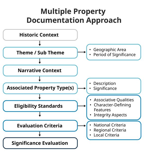


Each context, theme, and resource type combination is unique and has its own set of eligibility standards, character-defining and associative features, and integrity considerations. A template designed for SurveyLA to record these unique combinations guided the creation of data fields and related controlled vocabularies and drop-down lists for standardizing digital data collection (fig. 8.4). This approach enabled surveyors to consistently identify, classify, and evaluate resources by context, theme, and type as they were identified in the field or through research and outreach. Importantly, it also allowed surveyors to associate resources with one or more contexts and themes to fully represent multiple layers of significance.
| Label | Data |
|---|---|
| Context: | Architecture and Engineering, 1850–1980 |
| Sub Context: | Engineering, 1900–1985 |
| Theme: | Technological Developments in Construction |
| Sub Theme: | Hill Houses |
| Resource Type: | Residential |
| Resource Sub Type: | Single-Family Residence, Multi-Family Residential |
| Geographic Locations (where found in Los Angeles): | Hill districts of the city, particularly Silver Lake, the Hollywood Hills, Brentwood, Studio City, Sherman Oaks, Mount Washington, and Montecito Heights |
| Area(s) of Significance: | Engineering; Architecture |
| Evaluation Criteria: |
C/3/3 (National, California, City of Los Angeles) |
| Period of Significance: | 1920–1985 |
| Eligibility Standards (drop-down list for surveyors): |
|
| Character-Defining/Associative Features (drop-down list for surveyors): |
|
| Integrity Considerations for Resource Type: |
|
Designing historic contexts for digital data collection enables their use as analytical tools during the survey process. Over the course of fieldwork, for example, surveyors can map, review, and use context information to visualize the geographic distribution of resource types by theme. This in turn helps surveyors begin to understand the frequency, abundance, or rarity of each—factors important to comparative analysis and assessment of integrity thresholds.
When incorporated into a digital inventory, historic contexts can be managed and expanded over time to add new themes and resource types and to guide future survey work (fig. 8.5). This approach is increasingly being used in the United States and is a replicable model for digital surveys and inventories.
General Recommendations for Designing Historic Context– and Theme-Based Surveys
Surveys implementing an approach based on historic context or theme, such as the MPD format, require strategic planning and coordination, along with the overall development of survey tools and methods. It is recommended that a strategy be put into place to guide the development of the components of the approach, considering that they need to be completed before field surveys begin, including writing narrative historic context statements and integration into a digital data collection system. Other recommendations include:
-
Prioritize writing historic contexts/themes that will be needed for a pilot survey program and to coordinate with the sequencing or phasing plan adopted for the survey.
-
Expect that context statement narratives and associated eligibility standards may need revision during and after surveys based on actual survey findings and comparative analysis, and allow time for that work. Developing and revising historic contexts throughout a survey is an ongoing, iterative process.
Tips for Developing a Thematic Framework
The historic context approach as implemented for SurveyLA integrates the concept of a thematic framework (see the sidebar in chapter 2). In many countries, this concept is the mechanism used to organize surveys, akin to the concept of historic contexts. A thematic framework may be developed from the ground up—for example in places that have never been surveyed—or it may augment and update an existing framework. The baseline study for a survey will identify if there are existing frameworks in place that may be useful for a new survey.
The content of the thematic framework will reflect the survey scope and approach, as discussed in chapter 1 (see also fig. 6.1) and may cover a comprehensive range of themes relevant to the geographic area of a survey (e.g., citywide) or focus on limited themes and resource types, such as those not covered by previous surveys or that are underrepresented in inventories. Whatever approach is taken, consider these points:
-
As discussed in chapter 2, some countries have established national thematic frameworks, including guidance for their use, that may already be in place or can serve as a starting point to create a regional, state, or local thematic framework (see, e.g., National Park Service. 2018. National Historic Landmark Thematic Framework. https://home.nps.gov/subjects/nationalhistoriclandmarks/nhl-thematic-framework.htm; Parks Canada. 2000. “Thematic Framework.” In National Historic Sites of Canada: System Plan, 9–26. Gatineau, Quebec: Parks Canada. https://publications.gc.ca/collections/collection_2016/pc/R64-234-2000-eng.pdf; Australian Heritage Commission. 2001. Australian Historic Themes: A Framework for Use in Heritage Assessment and Management. Canberra: Australian Heritage Commission. https://repository.up.ac.za/bitstream/handle/2263/27059/Appendix 16.pdf?sequence=25; Heritage Council of Victoria. 2010. Victoria’s Framework of Historical Themes. Melbourne: Heritage Council of Victoria. https://www.heritage.vic.gov.au/__data/assets/pdf_file/0022/512275/Victorias-framework-of-historical-themes-Heritage-Council-of-Victoria,-Victorian-Aboriginal-Heritage-Council-2009.pdf). They may be used in whole or in part and can be adapted or expanded to include localized themes and heritage types.
-
The process of designing a thematic framework that is holistic and inclusive is best informed by a collective process. That is, the design process may engage a range of stakeholders (such as local historians, subject matter and community experts, scholars, and heritage organizations and agencies) in a series of workshops, brainstorming sessions, and other activities. Such an approach will help ensure that the framework is balanced, represents varied perspectives and disciplines, acknowledges interconnected histories, and covers diverse heritage themes and resource typologies.
-
A framework that is flexible and expandable can be adapted over time to account for changing interpretations of history, ongoing public input, new research and scholarship, and new discoveries during surveys and other data collection activities.
-
As discussed above under Designing Digital Surveys, a framework designed for digital data collection can facilitate both survey recording and analysis processes and the use of the information in the inventory.
Tips for Writing Narrative Historic Context Statements
The following tips may also relate to narrative thematic (or theme) studies (see the related sidebar in chapter 2), particularly when these studies are purposefully designed to guide surveys.6
-
A range of heritage organizations and agencies have published historic context statements and related theme studies that may provide useful information and can be studied as prototypes (see National Park Service. 2021. “Full List of Theme Studies.” National Historic Landmarks. https://www.nps.gov/subjects/nationalhistoriclandmarks/full-list-of-theme-studies.htm). SurveyLA’s citywide historic context statement, for example, has relevancy for other Southern California communities that share similar development patterns and related historical themes and associated resource types (see Los Angeles City Planning Department. n.d.c. “Historic Themes.” Accessed February 11, 2022. https://planning.lacity.gov/preservation-design/historic-resources/historic-themes).
-
As with other elements of survey methodology, historic context statements must be credible and defensible and developed according to accepted professional standards where applicable.
-
A historic context specialist is recommended to lead the process of designing and developing a context-based approach and to direct the work of the writers (see fig. 7.2).
-
Context writers can be members of the survey team or outside heritage professionals, scholars, local history experts, and others with proven experience researching and writing about relevant themes and resource types. Depending on the nature of the survey, areas of expertise may include architectural history, ethnic studies, archaeology, social history, and historic landscapes.
-
Community collaboration is essential when writing themes that require firsthand experience and specialized knowledge, such as ethnic and cultural histories. In such cases, advisory committees are particularly useful; when organized early on, they provide critical input to focus the theme narratives, direct and guide the writing process, and help foster overall community trust and buy-in for the process. Community collaboration can also include public meetings, workshops, and other activities.
-
Interns can support the work of writers and complete secondary tasks such as research, fact-checking, photography, and document formatting.
-
A writer’s guide like the one shown in resource 8.1, the Citywide Historic Context Statement: Resource Guide, created for SurveyLA, can be an important tool to provide direction to writers and to help ensure quality and consistent final products (Los Angeles City Planning Department. 2012. Citywide Historic Context Statement: Resource Guide. Los Angeles: City of Los Angeles, Department of City Planning. https://planning.lacity.gov/odocument/2afd953e-09b5-4463-a5db-2eba81a52bea/Historic_Context_Statement_Resource_Guide.pdf). The SurveyLA guide is both a useful prototype and a particularly relevant source for developing historic contexts using the MPD approach.
-
Training workshops are an efficient way to introduce and discuss the writer’s guide and to help ensure that writers have a common understanding of the writing process and the expected product. Workshops are also a good way for writers to meet, share their experiences, and have their questions addressed in a collaborative group setting.
Resource 8.1 Citywide Historic Context Statement: Resource Guide
Download Guide Download the PDF
Table of Contents
- PREFACE: Welcome Note From the Office of Historic Preservation
- 1.0 INTRODUCTION
-
2.0 THE CONTEXT STATEMENT AND THE MPD APPROACH
- 2.1 Organization of the SurveyLA HCS
-
3.0 WRITING THEMES
- 3.1 Theme Names
- 3.2 The Narrative Statement of Significance
- 3.3 Property Types
- 3.4 Eligibility Standards
- 3.5 Period of Significance
- 3.6 Areas of Significance
- 3.7 SurveyLA and the California Historical Resource (CHR) Status Codes
- 3.8 Guidelines for Applying the Status Codes for SurveyLA
- 3.9 Notes on Chapter 1 and Appendices
-
4.0 DEVELOPING WORK PLANS
- 4.1 Work Plan Tasks
-
5.0 THE HCS AND THE FIELD GUIDE SURVEY SYSTEM (FIGSS)
- 5.1 Context, Theme, and Property Type
- 5.2 Eligibility Standards: 1 of 2
- 5.3 Eligibility Standards: 2 of 2 (Integrity)
-
APPENDICES
- APPENDIX A: Criteria for Evaluation
- APPENDIX B: Areas of Significance
- APPENDIX C: CHR Status Codes
- APPENDIX D: Historic Property Definitions
- APPENDIX E: Additional Sources of Information
Public Outreach and Engagement
Public outreach and engagement programs are increasingly becoming integral components of heritage survey methodologies. This section provides an overview of the roles that outreach plays in a survey, offers recommendations for developing and administering an outreach program, and presents a range of outreach activities and materials to be considered.
The challenges and lessons learned from SurveyLA’s outreach approach highlight some primary considerations for outreach planning. First, outreach is an intensive effort that is highly dependent on qualified personnel and adequate funding. The lead agency or organization managing the survey is charged with allocating sufficient resources and time to plan and administer the outreach program, as well as to produce and publish outreach materials. Second, outreach is a long-term commitment; it should be a priority activity of the survey project from the outset and continue beyond the project to support use of the related inventory and community involvement in heritage conservation generally. Third, outreach activities are most effective when designed and sequenced to coordinate with the activities of the survey itself. Doing so will help ensure thoughtful allocation of resources and maximize the potential to inform and contribute to the survey. Finally, because not all outreach activities are as effective as expected, outreach should include a process to regularly assess successes and failures and adjust and revise approaches as needed.
Understanding the Role of Community Outreach and Engagement in a Survey
The extent and type of outreach may vary depending on the scope, goals, and objectives of a survey. No single method for approaching outreach works for every survey or every community within a survey (Derry, Anne, H. Ward Jandl, Carol D. Shull, and Jan Thorman. 1985. National Register Bulletin 24: Guidelines for Local Surveys: A Basis for Preservation Planning. Revised by Patricia L. Parker. Washington, DC: National Register of Historic Places. https://www.nps.gov/subjects/nationalregister/upload/NRB24-Complete_Part1t.pdf; https://www.nps.gov/subjects/nationalregister/upload/NRB24-Complete_Part2.pdf). Planning for and developing an outreach and engagement program requires an understanding of the role outreach plays in the survey overall and the intended audiences and participants. A robust program can serve multiple purposes and communicate with a range of stakeholders to support a survey, including:
-
To communicate the purpose and value of the survey
-
To address community concerns regarding the implications of the survey, including from a regulatory perspective, where applicable
-
To explain the survey process and keep the public informed throughout the process
-
To provide a range of activities to engage the public in the survey
-
To democratize the survey process and engage underrecognized and marginalized communities (Magalong, Michelle G. 2020. “Equity and Social Inclusion from the Ground Up: Historic Preservation in Asian American and Pacific Islander Communities.” In Preservation and Social Inclusion, edited by Erica Avrami, 147–156. New York: Columbia University Press. https://www.arch.columbia.edu/books/reader/503-preservation-and-social-inclusion%23reader-anchor-0#reader-anchor-15)
-
To earn community trust in the survey and ownership of the results
-
To build a volunteer base for the survey and provide a range of volunteer opportunities
-
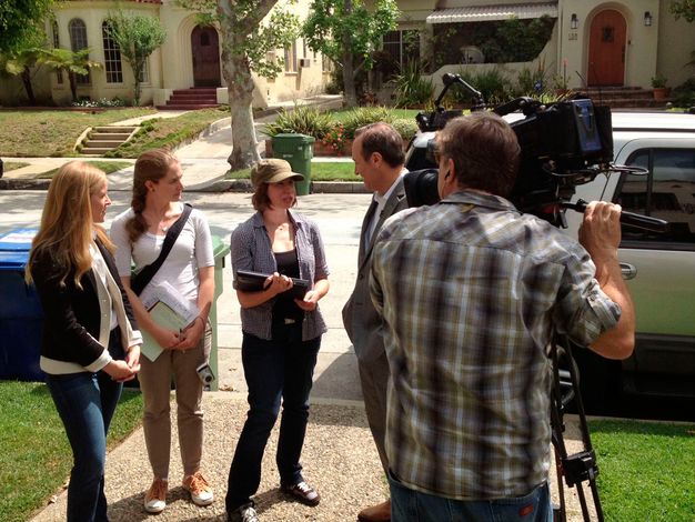
To create opportunities to support and advocate for the survey (fig. 8.6)
-
To encourage ongoing use of the survey information and resulting inventory once the survey is completed
A Note on Community-Based Heritage Surveys
One of the most intensive strategies for public involvement in modern heritage surveys is community-based or -led surveys whereby community members are engaged throughout the survey process to take a lead role in identifying and providing information on important heritage resources in a survey area. The approach can be particularly relevant for surveys that focus on intangible heritage and resources associated with ethnic and cultural histories and Indigenous peoples (UNESCO. n.d. “What Is Intangible Heritage?” Intangible Cultural Heritage. Accessed May 3, 2022. https://ich.unesco.org/en/what-is-intangible-heritage-00003; Mayor’s Fund for Philadelphia. 2021. “Request for Qualifications: A Plan for a City-Wide Cultural Resources Survey Delivered to the City of Philadelphia Department of Planning and Development.” http://philacityfund.org/wp-content/uploads/2021/05/RFQ-Final-Draft5.14.pdf).
While specific approaches to community-based surveys may vary depending on the focus of a survey, they generally involve collaborating with or working alongside experienced heritage professionals, who provide training and guidance to community members on principles and technical aspects of resource identification, research, and documentation. Community members provide valuable information and a range of perspectives to help inform resource evaluations. A community-based survey approach may have the benefit of supplementing project personnel for underfunded surveys (Heritage Council of New South Wales. 2013. Community-Based Heritage Studies: A Guide. Sydney: Office of Environment and Heritage on Behalf of the Heritage Council of New South Wales. https://webarchive.nla.gov.au/awa/20070413013512/http://pandora.nla.gov.au/pan/70190/20070413-0000/www.heritage.nsw.gov.au/docs/info_community2007.pdf).
Recommendations for Developing and Administering an Outreach and Engagement Program
Survey outreach and engagement programs can only be effective when they are well resourced, designed to maximize community input and collaboration, and are identifiable. Toward that goal, the following are recommended to be implemented during the development phase of an outreach program.
-
Provide qualified staff and adequate funding for outreach. As referenced above and illustrated in figures 7.2 and 8.7, recruiting dedicated staff with the required skillsets and expertise to plan, oversee, and conduct outreach is a primary responsibility of the managing agency or organization and should be integrated into the overall project administration strategy for the survey.
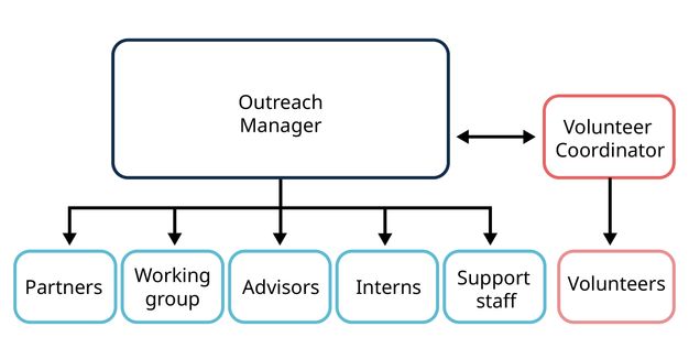
FIGURE 8.7 Heritage Survey Outreach Management Model illustrating key participants in developing and implementing a heritage outreach program. Janet Hansen -
Organize an outreach committee or working group to assist with developing an outreach approach. This group would ideally be organized once the survey project is initiated and during the planning phase of the survey to establish preliminary outreach goals and objectives, identify challenges and opportunities, and provide recommendations for the structure and content of the outreach program.
-
Identify outreach advisors to provide expertise and assistance with specialized populations, themes, geographic areas, or resource types. Advisors may have experience with specific audiences or communities where they have developed trust and established contacts and long-term relationships.
-
Develop partnerships and collaborations with targeted key individuals, organizations, and community groups that can provide opportunities to collectively contribute resources to supplement staff and often-stretched public outreach budgets. They may also be able to suggest creative approaches to plan for and carry out activities that meet mutual needs.
-
Leverage resources from the lead agency or organization to take advantage of existing outreach programs’ resources to develop outreach tools. In many jurisdictions in the United States, for example, heritage programs are located within planning agencies, which often have well-developed public relations and community outreach programs and outlets in place to inform and solicit input from the public on various planning initiatives. These strategies may be able to be adapted for the survey project. Likewise, these agencies may also allocate the time of specialized personnel and funds to produce tools and products, such as website or webpage development and support, and translation and printing costs.
-
Seek out grant opportunities. The lead agency or organization and project partners can secure support for outreach through grants, particularly those that focus on funding projects that champion inclusive approaches to outreach and civic engagement. SurveyLA relied heavily on grants to fund development, production, and translation costs of outreach materials.7
-
Brand the survey and outreach program. A survey name and logo help create an identity for the survey as a whole and are also essential in producing outreach materials that are readily associated with the project. For Los Angeles, SurveyLA was adopted as the brand for the citywide survey project, and MyHistoricLA branded the project’s outreach materials and programs (discussed below).
Sample Outreach Tools, Materials, and Activities
A range of tools, materials, and activities may be considered to support outreach. A number of options are presented below, each of which was implemented for SurveyLA. Materials and activities should be easily accessible, be sensitive to multilingual needs, and respect cultural values.
-
Website. A survey project website or webpage has the potential to reach a wide audience and serves multiple purposes. It can explain and describe the survey project, provide an ongoing means of following the progress of field surveyors, solicit community input on important places, and publish survey results. The site can also be used to advertise paid, volunteer, and internship opportunities and to promote community meetings and workshops. Given its reach and accessibility, a web presence is a top priority for outreach and is best developed at project initiation. The website can be maintained throughout the survey.8
-
Special activities. Special activities are defined as one-time or recurring events designed to promote one or more aspects of the survey project. One example would be a public meeting to announce the start of a survey project in a community or to celebrate the completion of a survey. Special activities can be held at any point during the survey project.
-
Community meetings and workshops. Community outreach meetings and workshops may be held throughout the survey, and their timing in the sequencing of a survey should be carefully considered. For example, community meetings may be scheduled in advance of field surveys to let residents know when surveys will begin, what to expect during the process, and how they can contribute information or become involved. Workshops and listening sessions may be planned to solicit expertise and participation in developing historic context statements and thematic studies, particularly those associated with specialized topics such as ethnic and cultural histories and intangible heritage.
-
Interviews and oral histories. Interviews with individuals and groups can provide valuable information about community histories as well as about specific heritage themes, typologies, and associated resources. Interviews can be informal or designed to meet professional standards in the field of oral history (e.g., those of the Oral History Association), although the latter can be costly and time consuming and may require advance planning. For some areas of SurveyLA, group interviews and conversations featured community-led neighborhood driving tours that were attended by field surveyors.
-
Public information documents. Handouts are relatively inexpensive to produce, are easily distributed, and serve a variety of purposes. Handouts developed for SurveyLA included:
-
Frequently asked questions (Los Angeles City Planning Department. n.d.d. “SurveyLA FAQs.” Accessed August 15, 2023. https://planning.lacity.gov/odocument/fe3186ea-cc35-4bce-94dd-4611f28e74ca/Info Brief SurveyLA FAQs.pdf)
-
General informational brochure
-
Flyers to advertise public meetings, workshops, and other survey events9
-
-
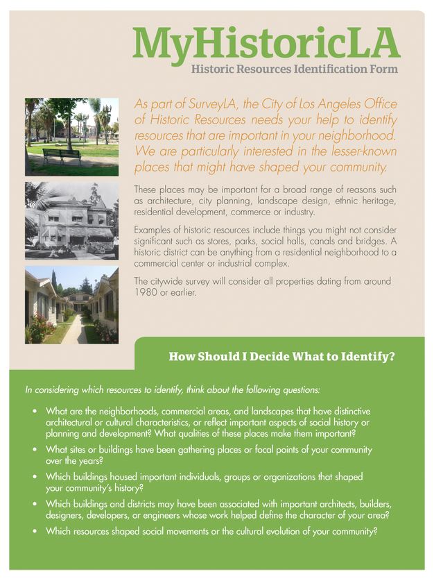
Questionnaires. A questionnaire like that in resource 8.2 can be designed to solicit ideas and information from the public about heritage resources that may be included in the survey. It can be produced in hard copy for distribution at public meetings and other venues and as an online form available on the project website, where it can be completed and submitted.
Resource 8.2 MyHistoricLA Historic Resources Identification Form developed for SurveyLA
Download Form Download the PDF

-
Project video. A survey project video, or videos, is a captivating approach to outreach that can widely and consistently introduce and/or summarize the project. It can be featured at public meetings, presentations, and workshops. If it is made available on the project website in a shareable format, video can be circulated by interested parties and through social media. For SurveyLA, an informational video titled SurveyLA: Preserving Los Angeles was produced by the City-owned and operated television station in English and Spanish (Los Angeles City Planning Department. 2008. SurveyLA: Preserving Los Angeles (video). https://planning.lacity.gov/surveyla-preserving-los-angeles-videos). It is available online in 30- and 15-minute formats and was also published as a DVD.
-
Social media and crowdsourcing. Social media platforms and online crowdsourcing activities can both be effective tools for survey outreach to reach widespread and varied audiences, promote interest and awareness, and provide opportunities for direct input and involvement. These tools can also provide a method to track online engagement (Hansen, Janet, and Sara Delgadillo Cruz. 2019. “Big City, Big Data: Los Angeles’s Historic Resources.” In Preservation and the New Data Landscape, edited by Erica Avrami. New York: Columbia University Press, 21–36. https://www.arch.columbia.edu/books/reader/370-preservation-and-the-new-data-landscape#reader-anchor-2). With the necessary metrics to evaluate outreach strategies, a managing agency or organization can bolster successful campaigns and adjust those that are less effective. (See Minner, Jennifer, Michael Holleran, Andrea Roberts, and Joshua Conrad. 2015. “Capturing Volunteered Historical Information: Lessons Learned from Development of a Local Government Crowdsourcing Tool.” International Journal of E-Planning Research 4, no. 1: 19–41. https://aap.cornell.edu/sites/default/files/minner_IJEPR 4(1).pdf for a case study of the use of crowdsourcing to inform heritage surveys in Austin, Texas.)
-
Community training guides and workshops. Training guides and related workshops are an effective means of giving community leaders and members the information and skills they need to contribute to survey initiatives. MyHistoricLA: Guide to Public Participation in SurveyLA (see resource 8.3) provided a range of activities to enable individuals, neighborhoods, and organizations to take ownership of and manage their own contributions to SurveyLA (Los Angeles City Planning Department. 2010. MyHistoricLA: Guide to Public Participation in SurveyLA. Los Angeles: City of Los Angeles, Department of City Planning. https://planning.lacity.gov/odocument/26a71b43-c31e-40da-9291-5d065e042d52/MyHistoricLA_Guide2010_with_cover.pdf).
-
Speakers bureau. A speakers bureau is a group of speakers, usually volunteers, who can educate and inform the public about a survey. In many ways, they are ambassadors for a survey project. The SurveyLA speakers bureau participants were enlisted through the project’s volunteer program. SurveyLA staff and consultants developed a training guide (see resource 8.4 for contents) and trained volunteers over three consecutive weekends.10 Speakers primarily presented in their own communities and in a number of venues such as community meetings and heritage-related events throughout Los Angeles. Managing and training a speakers bureau is time consuming but can be particularly important for large-scale surveys and those with a limited budget for outreach staff.
Resource 8.3 MyHistoricLA: Guide to Public Participation in SurveyLA
Download Guide Download the PDF
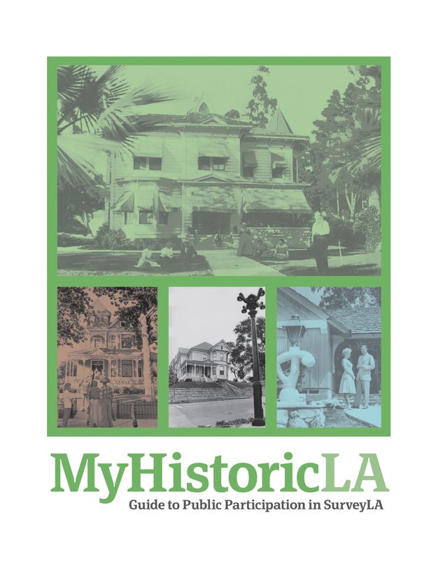
Table of Contents
- Introduction & Purpose
- SurveyLA Facts
- About MyHistoricLA
- MyNeighborhood
- MyStory
- MyPlace
-
Forms
- Neighborhood Walkabout Survey Form
- Photo Identification Form
- Interview Questionnaires
- Photo Release Form
- Interview Release Form
- MyHistoricLA Neighborhood Data Table User Guide
-
Appendices
- Organization & Community Outreach
- Beyond SurveyLA
- Additional Resources
- Contact Information – Office of Historic Resources
-
Reference Materials
- SurveyLA DVD
-
MyHistoricLA CD:
- Volunteer Registration Form and OHR Supplemental
- MyHistoricLA Historic Resources Identification Form
- MyHistoricLA PowerPoint
- MyHistoricLA Neighborhood Data Table
Resource 8.4 SurveyLA Speakers Bureau Training Guide
Table of Contents
-
Introduction to the Office of Historic Resources and
SurveyLA
- PowerPoint presentation printout
-
About SurveyLA
- Frequently Asked Questions
- Pilot Survey Program Fact Sheet
- SurveyLA Phasing Plan & Map
-
Preparing for Speaking Assignments
- Organizing Your Presentation
- Presentation Formats
- Introductory Script for Speakers
- Tips for Answering Questions
- Mastering Meetings
-
Materials for Speaking Assignments
- SurveyLA PowerPoint presentation (printed)
- SurveyLA PowerPoint presentation (digital file)
- SurveyLA Video DVD
- SurveyLA Brochures
- MyHistoricLA Historic Resource Identification Forms
- Volunteer Registration Form
-
Reference Resources
- Historic Designation Programs Fact Sheet
- Historic-Cultural Monuments & Historic Preservation Overlay Zones
- Mills Act Property Tax Abatement Program
- Preservation Resources
- Contract Information for Speakers
-
Miscellaneous Items
- Meeting Calendar
- Note Paper
Outreach and Digital Data Collection
Information and insights collected through community outreach can be formatted for compatibility with a survey’s digital data collection system, where it can be used as a reference layer (see Designing Digital Surveys) or as provisional data to be validated and/or enhanced. For SurveyLA, outreach information was gathered through a range of activities, as discussed above, in both hard-copy and electronic formats.
To make the outreach information most useful for the survey, the city’s Office of Historic Resources designed a spreadsheet and, with the primary assistance of graduate student interns, undertook a large-scale data entry effort to organize it as GIS reference data that would be readily available to field surveyors. The approach proved to be particularly important for resources associated with significant persons or events or that had social, ethnic, and cultural associations not readily apparent from field observations. It also provided a mechanism for letting the public know that the knowledge shared had been incorporated and utilized for the survey.
It is important to note, however, that the data entry process was intensive and time consuming and field surveyors needed to fact-check the information for accuracy before using it to inform resource evaluations. These factors must be considered and coordinated during the earliest phases of community outreach to have a reference layer ready when field surveys begin.
Notes
-
Most jurisdictions have separate guidelines and standards for surveying and recording built-heritage resources, archaeological resources, and other resource types. ↩︎
-
These terms are commonly used in the United States and Canada and are useful concepts internationally. Reconnaissance is also used broadly in reference to archaeological surveys that are not associated with excavation work. ↩︎
-
Specifically, SurveyLA did not include City-designated historic-cultural monuments or historic districts (known as Historic Preservation Overlay Zones), or properties listed in state or national registers. These resources and districts included thousands of properties, and to resurvey them would have substantially impacted the overall survey timeline. ↩︎
-
The field manual was fine-tuned as the surveys progressed to incorporate revisions to recording processes and data fields. ↩︎
-
For the SurveyLA citywide historic context outline and published narrative contexts/themes, see https://planning.lacity.gov/preservation-design/historic-resources/historic-themes. ↩︎
-
See also Nelson, Marie. n.d. “Writing Historic Contexts.” Sacramento: California Office of Historic Preservation. Accessed March 5, 2024. https://ohp.parks.ca.gov/pages/1054/files/WritingHistoricContexts.pdf ↩︎
-
In the United States, grants for survey work are available to local governments participating in the Certified Local Government program, which is administered by state preservation offices with funding distributed annually from the federal Historic Preservation Fund. ↩︎
-
Once SurveyLA was complete, the city closed the website. Information from SurveyLA is now available on the HistoricPlacesLA website (https://hpla.lacity.org/) and the Historic Preservation section of the Los Angeles City Planning website (https://planning.lacity.gov/). ↩︎
-
These materials were also available on the SurveyLA project website when it was active. ↩︎
-
The speakers bureau operated for approximately three years, after which the field surveys started and the outreach focus changed. ↩︎