This chapter describes how inventory and survey information has been used with respect to six specific heritage management issues deemed to be worthy of particular attention: recognizing cultural diversity, urban planning, heritage impact assessments, disaster preparedness and response, sea level rise, and armed conflict. The sections that follow include relevant considerations and examples from practice, and point to references for further reading.
Recognizing Diversity
The shift in many parts of the world in heritage practice to further recognize diversity and promote social inclusion has resulted in efforts to identify and document places associated with traditionally marginalized communities, including ethnic, racial, and religious minorities; indigenous people; women; those identifying as LGBTQ; and the economically disadvantaged (Avrami, Erica. 2021. “Preservation’s Reckoning.” In Preservation and Social Inclusion, edited by Erica Avrami, 9–19. New York: Columbia University Press. https://www.arch.columbia.edu/books/reader/503-preservation-and-social-inclusion%23reader-anchor-0#reader-anchor-0). To tell the whole story, heritage surveys and inventories are being designed to identify and document underrecognized communities and to make digital information widely available for a range of purposes.
Integral to these efforts are broad-based community outreach and engagement programs, and in some countries, thematic frameworks and historic context surveys—tools that directly involve the public in identifying a range of important historical themes and heritage types, both tangible and intangible, and in telling their stories. Importantly, surveys focusing on diverse populations have called into question traditional survey approaches and practices that focus on monumental buildings and notions of integrity solely defined on architectural quality.
Heritage designation or listing can be a significant step in integrating a wider range of histories and community narratives into inventories to inform planning initiatives and build collaborations with heritage-based agencies and organizations. Many organizations and jurisdictions are, in fact, designing and promoting surveys to focus specifically on properties and groups underrepresented in inventories and historic registers or designation lists (Mayor’s Fund for Philadelphia. 2021. “Request for Qualifications: A Plan for a City-Wide Cultural Resources Survey Delivered to the City of Philadelphia Department of Planning and Development.” http://philacityfund.org/wp-content/uploads/2021/05/RFQ-Final-Draft5.14.pdf; National Park Service. 2023. “Underrepresented Community Grants.” Historic Preservation Fund. https://www.nps.gov/subjects/historicpreservationfund/underrepresented-community-grants.htm). In the United States, such surveys and related historic contexts have resulted in an uptick of resources listed in the National Register and designated under local programs. Importantly, many of these nominations are being initiated by community organizations that have directly participated in creating historic contexts and identifying important resources through surveys and inventories.
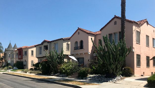
In Los Angeles, for example, SurveyLA and the subsequent creation of a Jewish History context statement spurred the community’s nomination of the Beverly Fairfax Historic District to the National Register (fig. 12.1) (Hansen, Janet, and Sara Delgadillo Cruz. 2020. “Los Angeles’s Historic Contexts: Pathways to Inclusion in Preservation.” In Preservation and Social Inclusion, edited by Erica Avrami. New York: Columbia University Press, 71–83. https://www.arch.columbia.edu/books/reader/503-preservation-and-social-inclusion#reader-anchor-8). That district reflects the westward shift in Los Angeles’s Jewish population starting in the 1920s, and by the end of the 1940s it was firmly established as the residential anchor of the city’s Jewish community. The nomination was made on behalf of Save Beverly Fairfax, an advocacy organization, working with a consultant team that surveyed the area for SurveyLA.
Surveys and inventories are accelerating the designation of resources that better represent an area’s diversity, but perhaps more importantly they are provoking discussions of how data can serve larger initiatives to celebrate community diversity and cultural identity. For governmental agencies, while heritage data is being used for city planning (see Urban Planning, below), it can also inform interdepartmental programs and initiatives relating to diversity and inclusion, for example, the activities of city offices associated with arts and culture.
Surveys and inventories are also supporting broader goals and objectives to create long-term collaborations and partnerships with heritage organizations and governmental agencies. The national organization Asian and Pacific Islander Americans in Historic Preservation (APIAHiP) partnered with the City of Los Angeles to identify places throughout the city related to Asian American histories. While the partnership culminated in a National Register Multiple Property Documentation form titled Asian Americans in Los Angeles, 1860–1980, it has also spurred APIAHiP to provide ongoing educational resources and advocacy support for other nominations in Los Angeles, as well as to continue in their efforts to promote inclusive preservation practices and policies nationwide (Magalong, Michelle G. 2020. “Equity and Social Inclusion from the Ground Up: Historic Preservation in Asian American and Pacific Islander Communities.” In Preservation and Social Inclusion, edited by Erica Avrami, 147–156. New York: Columbia University Press. https://www.arch.columbia.edu/books/reader/503-preservation-and-social-inclusion%23reader-anchor-0#reader-anchor-15). Other heritage organizations are using inclusive surveys and inventories to celebrate diversity through interpretive programs, heritage tours, and websites.
As more and more surveys and inventories are collecting and making available information on underrecognized communities, research opportunities are growing to, for example, initiate new or further studies on certain topics, themes, and heritage typologies. As well, digital data and mapping can inform analyses regarding the location and distribution of ethnic and cultural resources within a geographic area and related studies examining neighborhood growth and change, shifting demographics, overlapping histories, and intersectionality.
Urban Planning
Local governments throughout the world are increasingly using inventories and their associated surveys as tools to develop programs and policies that integrate heritage preservation into urban planning initiatives. Because planning practices and priorities change and evolve over time, heritage data that is up to date, comprehensive, and easily accessible will have the most relevancy for local planning. Today, cities of all sizes are creating or updating digital inventories and undertaking modern surveys as tools to manage heritage in urban environments that are changing rapidly, whether from growth or decline.
When survey and inventory datasets are integrated within land use databases and data sets, planners can overlay, map, visualize, and query heritage data in combination with land use information to understand the distribution and type of heritage resources present. Perhaps as important, planners will know places where heritage resources are less common and where development may proceed unimpeded.
While heritage data has traditionally supported stand-alone heritage programs and activities such as those related to resource designation, listing, and incentives, uses are expanding to include informing disaster preparedness and response programs, redevelopment initiatives, day-to-day development project review and impact assessment, and long-range community planning. In the United States, legacy cities experiencing decreasing populations and economic decline, such as Detroit, Michigan, and Muncie, Indiana, have undertaken so-called rapid mobile surveys to inform programs aimed at demolition of vacant and neglected buildings, many of which (despite their condition) meet heritage designation criteria and can contribute to neighborhood revitalization efforts (Evans, Emilie. 2014. “Smartphone Survey Contributes to Detroit’s Rightsizing Conversation.” National Trust for Historic Preservation, Preservation Leadership Forum.).
Other cities are using heritage data in thoughtful ways to inform community planning. These uses include crafting goals, policies, and programs that maintain and enhance the unique historic character of neighborhoods; establishing preservation priorities; encouraging restoration and adaptive reuse; regulating demolitions and alterations to existing buildings; providing guidelines for compatible new construction and infill development; and celebrating diversity and cultural identity. As discussed in part II, the City of Los Angeles organized and sequenced SurveyLA surveys to guide updates to the city’s geographically based community plans (Los Angeles City Planning Department. n.d.a. “Community Plan Updates.” Accessed August 3, 2023. https://planning.lacity.gov/plans-policies/community-plan-updates). These local land use plans guide future development in neighborhoods and are reshaping the city’s growth patterns around the region’s major investment in new transit lines.
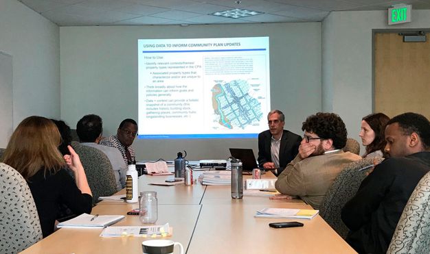
To facilitate broad-based thinking about how planners can use survey data, staff of the Office of Historic Resources developed and held workshops for city planners to summarize the survey process; provide an overview of the historical patterns of settlement, growth, and development in each plan area; and review survey findings for both individual heritage resources and potential historic districts. Overall, the training helped planners understand the prevailing character of each community, the range and location of significant heritage resources, and the typologies, contexts, and themes they represent (fig. 12.2).
Community plan tools informed by SurveyLA include character residential districts that provide for demolition and alteration review and compatible infill in potential residential historic districts (those meeting eligibility criteria for designation or listing), as an alternative to protections offered by historic designation. SurveyLA data has informed the development of other neighborhood planning tools, including special overlay zones for the city’s overhaul of its 1946 zoning code, as well as context-sensitive zoning in single-family neighborhoods (Bernstein, Ken, and Janet Hansen. 2016. “SurveyLA: Linking Historic Resource Surveys to Local Planning.” Journal of the American Planning Association 82, no. 2: 88–91. https://doi.org/10.1080/01944363.2015.1137199).
In some instances, surveys are being designed to focus on identifying and protecting overall neighborhood historic character rather than on documenting individually eligible resources (Bertron, Cara, and Randall Mason. 2012. Character Study Project: Developing a New Type of Historic Resource Survey. Philadelphia: University of Pennsylvania School of Design. https://www.design.upenn.edu/sites/default/files/Character_Study_Project.pdf; Historic England. 2017b. Understanding Place: Historic Area Assessments. UK: Historic England. https://historicengland.org.uk/images-books/publications/understanding-place-historic-area-assessments/heag146-understanding-place-haa/). Planners in Los Angeles have used SurveyLA data to identify planning districts: areas within historic neighborhoods that have consistent planning concepts and features—such as height, massing, setbacks, street trees, and streetlights—but may not meet significance thresholds for designation or listing as historic districts. The concept is akin to neighborhood conservation districts or areas used in many U.S. jurisdictions as tools to protect communities.
Heritage inventories and surveys can also be used to promote interdepartmental collaboration and information sharing regarding heritage assets owned or managed by other city departments outside of planning. Resource typologies may include infrastructure such as bridges, public art, street trees, streetlights, libraries, parks, and fire stations. Knowing which heritage resources are significant helps in developing capital improvement programs related to those that may be replaced, upgraded, rehabilitated, or decommissioned (Hansen, Janet, and Sara Delgadillo Cruz. 2019. “Big City, Big Data: Los Angeles’s Historic Resources.” In Preservation and the New Data Landscape, edited by Erica Avrami. New York: Columbia University Press, 21–36. https://www.arch.columbia.edu/books/reader/370-preservation-and-the-new-data-landscape#reader-anchor-2).
Heritage Impact Assessments
The legal and policy frameworks of many jurisdictions require heritage impact assessments (HIA) as part of broader land use planning processes known as environmental impact assessment. An HIA is a formal process to ensure that the cultural significance of heritage resources is taken into account when developing and designing proposals for change. As stated in Welsh guidance on HIAs, “Conservation is about the careful management of change. This means that it is vital to understand the implications of any proposed change—from deciding what to do and how to do it, to deciding whether or not to give consent” (Cadw 2017a. Heritage Impact Assessment in Wales. Cardiff: Welsh Government, Historic Environment Service (Cadw). https://cadw.gov.wales/advice-support/placemaking/heritage-impact-assessment/heritage-impact-assessment). HIAs typically relate to proposed development projects, as well as proposed substantial modifications to or changes in the use of places. Many HIA regimes consider impacts of proposed changes that would affect heritage significance, including aspects such as setting and views associated with heritage resources (Historic England. 2017a. The Setting of Heritage Assets: Historic Environment Good Practice Advice in Planning Note 3, 2nd ed. Swindon, UK: Historic England. https://historicengland.org.uk/images-books/publications/gpa3-setting-of-heritage-assets/heag180-gpa3-setting-heritage-assets/). Impact assessment processes normally provide for public input and engagement.
A key typical outcome of an HIA process is determination of whether a permit or consent for a proposed project will be approved or denied, whether it might be approved under certain conditions or with modifications, or, if the project proposal offered different options, whether a certain option is preferred. Depending on the legal and policy context, in some cases the HIA process may determine that heritage resources can be demolished or destroyed through development but require mitigation through their investigation, documentation, and possibly recovery of artifacts.
Legal and policy frameworks commonly define a specific threshold that triggers the HIA process. Many jurisdictions also require that related investigations be carried out according to professional standards, including that those personnel involved meet qualification standards.
Once triggered, an initial step of an HIA process is to determine the presence or absence of any culturally significant, or potentially significant, heritage resources within the area to be affected. This determination is ordinarily first pursued by consulting the relevant heritage inventory. For an inventory to be effective for use in HIA processes, its information should, ideally, cover the area of jurisdiction comprehensively, the geographic location and extent of heritage resources should be accurately recorded, and the inventory information should be relatively current. Some places, including the United States, require that new information be collected for HIA processes if existing inventory or survey information is beyond a certain age. The inventory would also ideally reference when, where, and how field surveys or investigations have been undertaken, as well as related reports or documentation, to help determine whether new information gathering is needed.
It is also beneficial for prior investigations to record the absence of significant heritage resources for the area examined. This type of information is valuable for knowing where development projects can be directed to avoid negatively impacting heritage.
If inventory information for the project area is absent, outdated, or lacks sufficient detail, it is recommended that actions be taken to collect or update data to inform the HIA process. If all or part of the project area has never been investigated to identify heritage resources, new research and investigations may need to be commissioned to inform the HIA process. Some jurisdictions require that those submitting proposed projects pay for at least part of the investigations or studies required for a related HIA process. Many government agencies have administrative processes tied directly to statutory heritage inventories that track the status and outcomes of HIAs (Mlungwana, Nonyameko. 2015. “Using SAHRIS a Web-Based Application for Creating Heritage Cases and Permit Applications.” ISPRS Annals of the Photogrammetry, Remote Sensing and Spatial Information Sciences XL-5/W7: 337–41. https://doi.org/10.5194/isprsarchives-XL-5-W7-337-2015).
There is often some degree of uncertainty about whether archaeological resources exist within areas of a jurisdiction not yet investigated. Such features might be present but not visible: underground, under existing development, underwater, or obscured by vegetation. HIA processes regularly employ archaeological predictive modeling to assess the likelihood of the presence of archaeological remains based on a range of factors, including patterns within the current archaeological record for the area in question. Sources for establishing such patterns may include existing inventory information, records from prior field investigations, and historical map regression.
Predictive modeling has been applied to produce maps of archaeological sensitivity (also called archaeological priority and archaeological potential) that require differing levels of investigation, consultation, or caution when approaching proposed development projects. For example, Historic England’s Greater London Archaeological Advisory Service utilizes a set of formally defined and mapped Archaeological Priority Areas (fig. 12.3), in combination with the Greater London Historic Environment Record, when assessing the potential impact of development proposals within its jurisdiction (Historic England. 2016. Greater London: Archaeological Priority Area Guidelines. UK: Historic England. https://historicengland.org.uk/images-books/publications/greater-london-archaeological-priority-area-guidelines/heag098-glaas-archaeological-priority-areas/, Historic England. n.d. “Greater London Archaeological Priority Areas.” Historic England. Accessed January 8, 2022. https://historicengland.org.uk/services-skills/our-planning-services/greater-london-archaeology-advisory-service/greater-london-archaeological-priority-areas/).
| Archaeological Risk Model | Outside APA | Archaeological Priority Area | ||
|---|---|---|---|---|
| Scale of development | Tier 4 | Tier 3 | Tier 2 | Tier 1 |
|
4 large major Site area 2 hectares of more |
Medium* | High | High | High |
| Low | ||||
|
2 minor Site area less than 0.5 hectares New basements |
Negligible | Low | Medium | High |
|
1 very minor Householder developments** and equivalent minor works |
Negligible | Negligible | Negligible | Medium |
- * Very large majors with a site area of 10 hectares or more
- ** Other than new or extended basements
Disaster Preparedness and Response
The most fundamental requirement for safeguarding heritage when facing natural disasters is identifying its location, significance, and vulnerabilities. Heritage inventories and related data collection activities such as surveys are vital to meeting this requirement.
The practice of cultural heritage disaster preparedness and response has been extensively studied, with various methodologies proposed. The disaster risk management framework of the ARCH project (fig. 12.4) conveys one such approach (Milde, Katharina, Daniel Lückerath, and Oliver Ullrich. 2020. ARCH Disaster Risk Management Framework. Germany: ARCH. https://savingculturalheritage.eu/fileadmin/user_upload/Deliverables/ARCH_D7.3_Disaster_Risk_Management_Framework_v20201130-FINAL.pdf).1 While details of different methodologies vary, they generally approach natural disasters in three phases: predisaster preparation, responding during a disaster, and postdisaster activities, as discussed in the following sections in terms of considerations specific to inventories and surveys (see Stovel, Herb. 1998. Risk Preparedness: A Management Manual for World Cultural Heritage. Rome: ICCROM. https://www.iccrom.org/publication/risk-preparedness-management-manual-world-cultural-heritage).

Predisaster Preparation
Steps taken in anticipation of disasters—to reduce risk and adverse consequences—include the following:
-
Prepare the ground. This stage includes the central task of identifying and documenting significant heritage resources through ongoing preparation and maintenance of an inventory, including through surveys. Doing so provides baseline information about what heritage needs to be protected. This data is required to carry out subsequent steps in the disaster preparedness and response process, yet the importance of this work as an investment in disaster preparedness is seemingly overlooked in many published sources devoted to the topic. The more a heritage agency’s inventory is complete, current, accurate, and accessible, the better the agency can be prepared for a disaster. Because disaster events often span across jurisdictional boundaries, response efforts can also benefit from standardized data that is readily shareable with external agencies (McCarthy, Deidre. 2013. “Facing Disaster: The Importance of Heritage Inventories in Preparation and Response.” Conservation Perspectives: The GCI Newsletter 28, no. 2 (Fall): 16–17. https://www.getty.edu/conservation/publications_resources/newsletters/pdf/v28n2.pdf). Heritage recording guidance also advises that digital repositories, including inventories, should be backed up in a secure alternate location to prevent loss due to disasters (ICOMOS. 1996. Principles for the Recording of Monuments, Groups of Buildings and Sites. Paris: ICOMOS. https://www.icomos.org/en/charters-and-texts/179-articles-en-francais/ressources/charters-and-standards/387-principles-for-the-recording-of-monuments-groups-of-buildings-and-sites-1996).
-
Assess vulnerabilities and risks. Disaster preparedness requires systematically assessing vulnerabilities of and risks to identified heritage resources in relation to the types of natural hazards likely to occur in the specific geographic area. Current, high-quality inventory information and related contextual data (particularly geospatial) provide an essential basis for carrying out such analyses.
-
Mitigate risks in advance. The assessment of vulnerabilities and risks to heritage identified in an inventory can lead to designing interventions to mitigate harmful effects of future disasters. For example, the U.S. state of Washington, susceptible to periodic earthquakes, commissioned the creation of a statewide inventory of masonry buildings not reinforced to withstand seismic events (Architectural Resources Group. 2018. Washington Unreinforced Masonry Building Inventory. Olympia: Washington Department of Commerce. http://www.commerce.wa.gov/wp-content/uploads/2019/03/COMMERCE-ARG-URM-Inventory-Opt4.pdf). This inventory of several thousand buildings was created through both reviewing existing data in state and local inventories and conducting new field assessments. This analysis led to an ongoing program to provide for new interventions to reinforce buildings determined to be at risk. Inclusion of the function of buildings (e.g., hospitals, fire stations, schools) has helped prioritize interventions. Determining appropriate interventions often requires research, particularly in looking at lessons from past disasters.
-
Prepare response procedures. In certain cases, inventories and surveys can also help in preparing response procedures in advance of a disaster. For example, the identification of mudbrick historic buildings within a city’s inventory may help determine for which buildings nonwater fire retardants should be used in the case of fire.
Responding During a Disaster
The reaction during a disaster to mobilize, assess impacts, and prevent further damage includes the following:
-
Mobilize resources and personnel to carry out emergency response plans. If properly detailed, an inventory may help with search-and-rescue efforts in the first three to seven days after disaster strikes. For example, in certain cases the managers of an inventory may decide to include architectural plans for certain structures in the inventory to aid emergency responders in their efforts.
-
Identify which heritage items to prioritize. A heritage inventory is a primary source for identifying which significant heritage should be prioritized for attention as soon as disaster strikes, in accordance with an emergency response plan, if one has been prepared. A properly detailed inventory can be important for prioritizing temporary stabilization and protection of important heritage items, for identifying which heritage should preferably not be demolished, and for salvaging significant architectural elements or artifacts from damaged or collapsed structures.
Postdisaster Activities
Measures taken after a disaster to continue to assess impacts, plan and implement actions to repair and conserve or restore heritage, and to prevent future damage include the following:
-
Assess and document conditions of heritage resources and prioritize interventions. As is the case with predisaster preparations, having a robust inventory already in place provides a ready basis for planning, carrying out, and recording assessments of the condition of heritage resources. This also affords a foundation for determining priorities for short-, medium-, and long-term response when considering all resources across an entire jurisdiction or area. This typically involves carrying out field surveys to assess and document conditions.
-
Rebuild or reconstruct as the situation requires. As with previous steps, an inventory can provide a necessary basis for planning, tracking the implementation of, and documenting postdisaster interventions.
-
Feedback into the inventory. To further the aim of keeping inventory information current, it is recommended that relevant information from postdisaster assessments of conditions of heritage resources, as well as postdisaster interventions, be fed into inventories.
Experience has shown that natural disasters are an ultimate test of the completeness, quality, and usability of heritage inventories. As noted by McCarthy (McCarthy, Deidre. 2013. “Facing Disaster: The Importance of Heritage Inventories in Preparation and Response.” Conservation Perspectives: The GCI Newsletter 28, no. 2 (Fall): 16–17. https://www.getty.edu/conservation/publications_resources/newsletters/pdf/v28n2.pdf), “Without an accurate inventory, responders spend valuable time identifying instead of evaluating resources, slowing the response and preventing recovery.” In some cases, disasters have revealed the urgent need for more robust inventories, which has in turn led to renewed investments in inventory preparation (ICOMOS Nepal. 2015. Traditional Building Inventory: Nepal. An Initiative to Document Traditional Buildings to Facilitate Culturally Sensitive Rebuilding Process in Post-Earthquake Recovery Process in Nepal. Kathmandu: UNESCO Office in Kathmandu. https://openarchive.icomos.org/id/eprint/2274/1/259811eng.pdf).
Sea Level Rise
Heritage in coastal areas is under increasing threat from global sea level rise, as well as severe coastal storms and erosion, induced by global climate change. As with other types of natural disasters, identifying heritage places through inventories and related surveys is a crucial first step to understanding which heritage is at risk, and that knowledge underpins determining appropriate responses. As the U.S. state of Florida’s guidance for climate change vulnerability assessments and adaptation planning notes, “a large part of setting the planning context will include identifying and inventorying existing historic and cultural resources. . . . If no baseline inventory currently exists, the involvement of historic preservation agencies and organizations is important in the creation of a new historic resource inventory” (Florida Department of Economic Opportunity. 2015. Adaptation Planning for Historic Properties. Tallahassee: Florida Department of Economic Opportunity. https://floridadep.gov/sites/default/files/CRI_Adaptation_Historic_Properties_0.pdf). If a heritage inventory for a coastal area is incomplete, areas that have not been investigated and that are most vulnerable to sea level rise–related impacts may be prioritized to be surveyed. Inventories in some places include submerged heritage resources; inventories of such resources may become increasingly necessary as sea levels rise.
Once heritage resources have been identified and recorded, steps may be taken to assess the vulnerability of those resources to impacts resulting from sea level rise. It may be important to carry out a survey to establish baseline conditions of at-risk heritage resources. This information can provide a basis for periodic monitoring of change, which might include focusing on indicators providing an early warning of resources at high risk.
Given the large number of heritage sites to be monitored in many coastal regions, several public heritage agencies, universities, and NGOs have organized and trained students and volunteers to complement the work of heritage professionals in carrying out ongoing condition surveys monitoring impacts and threats to archaeological sites. These efforts have also identified unrecorded sites to be added to heritage inventories. Such work includes Scotland’s Coastal Heritage at Risk project, the Florida Public Archaeology Network (FPAN)’s Heritage Monitoring Scouts, the Mississippi River Delta Archeological Mitigation Project, and Maine’s Midden Minders (Dawson, Tom, Joanna Hambly, Alice Kelley, William Lees, and Sarah Miller. 2020. “Coastal Heritage, Global Climate Change, Public Engagement, and Citizen Science.” Proceedings of the National Academy of Sciences of the United States of America 117, no. 15: 8280–86. https://www.ncbi.nlm.nih.gov/pmc/articles/PMC7165427/; Britt, Tadd, David J. Watt, Mark Rees, Kory Konsoer, and Samuel M. Huey. 2020. “A Perfect Storm: An Archaeological Management Crisis in the Mississippi River Delta.” Parks Stewardship Forum 36, no. 1: 70–76. https://parks.berkeley.edu/psf/?p=1651).
Data from heritage inventories and related surveys can also provide a basis for predictive modeling to forecast future higher sea levels, storm surges, and other negative impacts as an additional step in vulnerability analysis (Miller, Sarah E., and Emily Jane Murray. 2018. “Heritage Monitoring Scouts: Engaging the Public to Monitor Sites at Risk Across Florida.” Conservation and Management of Archaeological Sites 20, no. 4: 234–60. https://www.tandfonline.com/doi/full/10.1080/13505033.2018.1516455). Such modeling typically considers the location of known heritage resources relative to surrounding topography and in relation to predicted scenarios of sea level rise, storm surges, and other environmental factors (fig. 12.5).
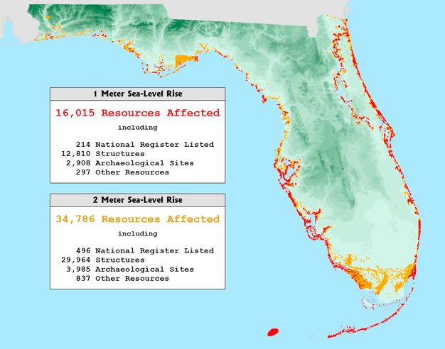
Through vulnerability analysis and predictive modeling, agencies can then identify, evaluate, and prioritize appropriate responses (Taylor Engineering, The Craig Group; Archaeological Consultants, Marquis Latimer + Halback, and PlaceEconomics. 2020. Resilient Heritage in the Nation’s Oldest City: St. Augustine, FL (final report Prepared for City of St. Augustine). https://www.citystaug.com/DocumentCenter/View/4058/St-Augustine-Resilient-Heritage-Report?bidId). This process may involve modeling and then planning for a range of scenarios due to uncertainties about future changes. Predictive modeling and condition monitoring can together aid in identifying and prioritizing responses based on the significance of heritage resources and their corresponding vulnerability. If heritage is expected to be destroyed or abandoned, or if resources are limited and other heritage places are deemed to be of higher priority, potential responses may include excavation (in the case of archaeological sites) or more detailed recording. Alternatively, if heritage resources are deemed to be of particular significance, if resources are available, and if such adaptations are feasible and have limited negative impacts on the integrity of heritage resources, plans may be made for interventions to adapt heritage resources or their surroundings to mitigate the effects of sea level rise. Examples include reducing groundwater extraction (which can cause ground subsidence), constructing barriers and other water-diversion and pumping mechanisms, raising the height of structures, and relocating structures away from eroding coastlines.
Armed Conflict
In the case of armed conflicts, inventories and related surveys are essential measures for heritage protection as well as rehabilitation. Inventories are an important component of the 1999 Second Protocol to the Hague Convention of 1954, which explicitly calls for inventory compilation as a peacetime preparatory measure.
A practical implication for nations that are signatories to the 1954 Hague Convention, or otherwise choose to comply with it, is that their armed forces are obliged to identify cultural sites deemed to be “of great importance” through no-strike lists of locations to be avoided in military operations, whether aerial bombing, missile strikes, or ground-based or naval operations. Through the published Guidelines for the Implementation of the 1999 Second Protocol (UNESCO. 2019. Guidelines for the Implementation of the 1999 Second Protocol to the Hague Convention of 1954 for the Protection of Cultural Property in the Event of Armed Conflict. Paris: UNESCO. https://en.unesco.org/sites/default/files/1999_Protocol_Guidelines_EN_2020.pdf), national governments may under certain conditions apply to the Committee for the Protection of Cultural Property in the Event of Armed Conflict for inventory and survey support specifically relating to preparedness for and response to armed conflict; this support is available through a fund set aside for the purpose. Such support during peacetime may take the form of technical advice on preparing and updating inventories and undertaking surveys; during armed conflicts it may include emergency support for preparing inventories and surveys. The Guidelines also provide that national governments may request expert advice through UNESCO regarding the preparation and regular updating of inventories.2
The identification of cultural sites near legitimate military targets can also lead to those targets being placed on restricted-target lists, according to which any attack on the objective must be conducted under stringent conditions, such as employing a specific weapon, to limit collateral damage to the nearby cultural property. However, as O’Keefe et al. (O’Keefe, Roger, Camille Péron, Tofig Musayev, and Gianluca Ferrari. 2016. Protection of Cultural Property: Military Manual. Paris: UNESCO. https://unesdoc.unesco.org/ark:/48223/pf0000246633) note,
But information gathering is only the first step. Information gathered must be communicated in accessible, utilizable form to those engaged in the planning and execution of military operations. How this is done will depend largely on the military operation in question. In the case of targeting decisions, best practice involves the compilation and entry into any relevant military databases of official “no-strike” lists. . . . In the case of planning for ground attack and subsequent belligerent occupation, it may involve the preparation and distribution of detailed, specially marked maps.
Cooperation and consultation between militaries and heritage organizations, such as international and national committees of the Blue Shield,3 as well as other heritage organizations and professionals, are essential to effectively compiling and conveying such lists. It is not a military skillset to identify what is cultural heritage “of great importance.” Archaeologist Peter Stone has conveyed related practical considerations based on his experience as advisor to the U.K. Ministry of Defence regarding the protection of archaeological sites in Iraq leading up to the invasion of 2003, as well as with respect to conflicts in Libya in 2011 and Mali in 2012 (Stone, Peter. 2013. “War and Heritage: Using Inventories to Protect Cultural Property.” Conservation Perspectives: The GCI Newsletter 28, no. 2 (Fall): 13–15. https://www.getty.edu/conservation/publications_resources/newsletters/pdf/v28n2.pdf). Unfortunately, experience has shown that often such no-strike lists have been hastily prepared in the lead-up to conflicts, resulting in limited information (Gerstenblith, Patty. 2006. “From Bamiyan to Baghdad: Warfare and the Preservation of Cultural Heritage at the Beginning of the 21st Century.” Georgetown Journal of International Law 37, no. 2: 245–351. https://archive.law.upenn.edu/live/files/6422-gerstenblith-patty-2006-from-bamiyan-to-baghdadpdf; Kane, Susan. 2013. “Lessons Learned from Libya.” SAA Archaeological Record 13, no. 3: 9–13. https://cdn.coverstand.com/16146/160407/ee3ecb83f081f4a261ae78f32d37c4599479e02d.1.pdf). Worse, if they fall into the wrong hands, no-strike lists can also be used to intentionally target heritage (Cunliffe, Emma. 2020. “No Strike Lists—From Use to Abuse?” Heritage in War. https://www.heritageinwar.com/single-post/2020/01/24/trump-and-iranian-cultural-property-heritage-destruction-war-crimes-and-the-implications).
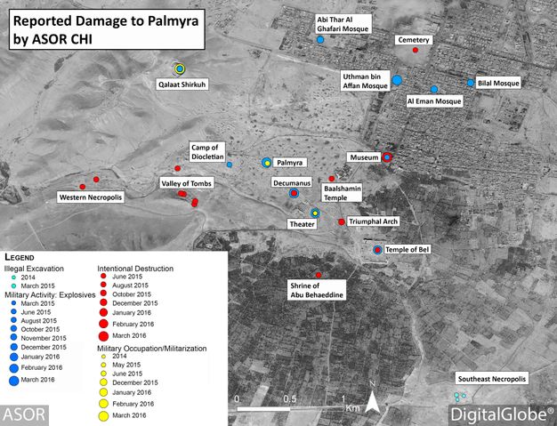
Inventories and related condition surveys are also key tools for systematically determining intervention priorities to rehabilitate heritage places damaged during armed conflicts. Using remote sensing technologies, such as satellite imagery, in conjunction with inventories, it is possible to carry out ongoing damage assessments during conflicts to help prepare postconflict intervention priorities and plans (fig. 12.6) (Fiol, Manuel, and Youmna Tabet, eds. 2018. Five Years of Conflict: The State of Cultural Heritage in the Ancient City of Aleppo. A Comprehensive Multi-temporal Satellite Imagery-Based Damage Analysis for the Ancient City of Aleppo. Paris: UNESCO and UNITAR. https://unesdoc.unesco.org/ark:/48223/pf0000265826/PDF/265826eng.pdf.multi; Danti, Michael, Scott Branting, and Susan Penacho. 2017. “The American Schools of Oriental Research Cultural Heritage Initiatives: Monitoring Cultural Heritage in Syria and Northern Iraq by Geospatial Imagery.” Geosciences 7, no. 4: 95. https://doi.org/10.3390/geosciences7040095). These remote activities can be supplemented by on-the-ground surveys when feasible.
Inventories and surveys also have contributed to the legal prosecution of those involved in intentional destruction of cultural heritage during armed conflicts. During the Balkan wars of the 1990s, amid the collapse of the nation of Yugoslavia, military forces intentionally targeted, damaged, and destroyed sites of cultural significance, including places of worship, archives, and libraries. In response, heritage specialists carried out extensive surveys of hundreds of cultural sites to document the extent and nature of damages. Evidence gathered, in addition to comparison with prior heritage inventory records, documented systematic intentional destruction of numerous culturally significant sites (Riedlmayer, András. 2002. The Destruction of Cultural Heritage in Bosnia-Herzegovina, 1992–1996: A Post-War Survey of Selected Municipalities. Expert Report commissioned by the International Criminal Tribunal for the Former Yugoslavia. https://archnet.org/publications/3481, Riedlmayer, András. 2007. “Crimes of War, Crimes of Peace: Destruction of Libraries during and after the Balkan Wars of the 1990s.” Library Trends 56, no. 1: 107–32. http://hdl.handle.net/2142/3784). This evidence contributed to the indictment and eventual conviction of several individuals for crimes against humanity at the International Criminal Tribunal for the Former Yugoslavia at the Hague (SENSE Transitional Justice Center. 2024. “Completion of the Project Targeting History and Memory.” https://sensecentar.org/activities/completion-project-targeting-history-and-memory).
Notes
-
ARCH (Advancing Resilience of Historic Areas against Climate-Related and Other Hazards) was a European-funded research project running from 2019 to 2022 that aimed to better preserve areas of cultural heritage from hazards and risks. The project teamed with the cities of Bratislava, Slovakia; Camerino, Italy; Hamburg, Germany; and Valencia, Spain, to cocreate tools to help cities save cultural heritage from the effects of climate change. The ARCH website (https://savingculturalheritage.eu/) offers a wealth of information, tools, and other resources. ↩︎
-
See https://en.unesco.org/protecting-heritage/International-fund for details on the fund and how to apply. ↩︎
-
The Blue Shield is an international organization founded in 1996 to protect the world’s cultural heritage from threats such as armed conflict and natural disasters. The Blue Shield is an advisory body to UNESCO on the protection of cultural property in the event of armed conflict with a legally granted mandate under the Hague Convention’s 1999 Second Protocol. The Blue Shield is formed from national committees around the world, coordinated by the Blue Shield International Board. More details are available at https://theblueshield.org/. ↩︎