A primary impetus for this publication is to share the experiences and lessons learned from SurveyLA, the citywide heritage resources survey of Los Angeles, and the related implementation of HistoricPlacesLA, the city’s heritage inventory.
SurveyLA is considered a groundbreaking project for several reasons. It covered all of Los Angeles, about five hundred square miles (eight hundred square kilometers) and 880,000 legal property parcels, making it undoubtedly the largest single urban heritage resources survey ever conducted in the United States, and perhaps internationally (fig. 5.1). The massive scale of the survey posed particular challenges with respect to its design and implementation, including how to consistently evaluate and document a large number of heritage resources.
SurveyLA was also the first all-digital citywide survey of such scale in the country, which presented substantial data collection and management challenges. And SurveyLA achieved success through a public-private partnership between the J. Paul Getty Trust, a private philanthropic organization, and the City of Los Angeles. The Getty’s involvement was motivated by a desire to provide support to its local community of Los Angeles and to undertake the project as a demonstration that would serve as a model to be followed by other cities.
Groundwork
Groundwork for SurveyLA was initially laid in 2000 when the Getty Conservation Institute (GCI) commissioned a study to assess the need for and benefits of a citywide survey of Los Angeles. The GCI’s resulting Los Angeles Historic Resource Survey Assessment Project Summary Report (Howe, Kathryn Welch. 2001. Los Angeles Historic Resource Survey Assessment Project: Summary Report. Los Angeles: Getty Conservation Institute. https://www.getty.edu/conservation/publications_resources/pdf_publications/lahrs_summary_report.html) revealed that about 15 percent of the city had previously been surveyed and that these surveys were maintained by diverse city agencies and departments and for a range of purposes.1 Moreover, prior surveys covered a limited temporal range of heritage resources and geographic areas, used varied and inconsistent data collection methods, and were largely outdated and inaccessible.
Importantly, the assessment project also revealed broad support for having reliable and up-to-date information on heritage resources from a wide range of public and private interests, including city government, neighborhoods, the business community, the development sector, and preservationists. This support underscored the growing need for a citywide survey to serve as the foundation for a comprehensive municipal preservation program and integration of preservation in all facets of city planning.
Research
Following the assessment project, the GCI began preparing a series of research papers, known as white papers, on national best practices in implementing and utilizing heritage surveys, to provide a recommended approach for undertaking a Los Angeles survey. The papers covered topics including survey standards and resource evaluation criteria, community engagement, information management and dissemination, and project funding. The GCI presented the papers to managers in multiple city departments and agencies and received feedback. Following finalization and endorsement of the papers in 2004, the Los Angeles City Council passed a series of resolutions that further advanced the city’s commitment to completing a citywide survey. The white papers were later published by the GCI as The Los Angeles Historic Resource Survey Report: A Framework for a Citywide Historic Resource Survey (Howe, Kathryn Welch. 2008. The Los Angeles Historic Resource Survey Report: A Framework for a Citywide Historic Resource Survey. Los Angeles: Getty Conservation Institute. https://www.getty.edu/conservation/publications_resources/pdf_publications/la_historic_resource_survey_full.html).
Survey Effort
In 2005 the City of Los Angeles entered into a multiyear grant agreement with the Getty Foundation to complete the survey, with Getty funding underwriting a portion of the project and the GCI providing advisory support to plan the survey process. Within a year, SurveyLA launched, when the Los Angeles City Planning department established and staffed the new Office of Historic Resources (OHR) as the managing agency for both the survey and the city’s preservation program. The GCI worked with the OHR to get SurveyLA off the ground and continued to provide research, technical, and advisory assistance throughout the project’s duration.
The GCI survey report became the blueprint the OHR used to develop a comprehensive plan for a massive survey effort that would be designed to meet California and U.S. federal professional standards and guidelines for survey work; engage and involve the public; cover a wide range of architectural, historic, ethnic, and cultural themes; record various heritage resource typologies; and generate data that was usable and accessible.
Initiation Phase
The two-part plan included an initiation phase, during which survey tools and methods would be developed and tested, and an implementation phase, when the field surveys would be completed.
During the initiation phase, the OHR brought on a team of preservation consultants to assist planning staff with developing tools and methods to meet survey goals and objectives while creating efficiencies of scale to stay on schedule and within budget. When SurveyLA started, no off-the-shelf software designed for heritage resources data collection existed. To meet the goal of an all-digital survey as recommended by the Getty report, the project team developed an in-house customized geographic information system (GIS) survey application loaded on portable tablet computers for use in the field.2
The GCI augmented the survey budget to assist with unanticipated costs associated with developing and testing the survey system throughout the initiation phase. Other survey tools included a citywide historic context statement designed to provide a consistent framework to identify, record, and evaluate resources during the survey, and an extensive public outreach program to engage a wide and diverse audience in all aspects of the project.
Pilot Surveys
The initiation phase culminated in three pilot surveys to test survey methods and tools in the field. Consultant teams received classroom and field training prior to going out on their own. Pilot surveys included a variety of heritage resource types, covered multiple historic themes of the citywide context, and took surveyors to differing geographic locations. Throughout the pilot program, tools and methods were refined and revised, and in some cases rethought.
Implementation Phase
The implementation phase began in 2010 and constituted the official start of SurveyLA field surveys. Following additional training, consultant teams worked methodically through the city following the phased survey approach developed by the OHR. This approach established ten survey groups, each composed of one or more of the city’s thirty-five geographically based community plan areas, thus providing a direct link between the survey project and land use planning.
Although originally scheduled for a three-year period, the field surveys took over seven years to complete, largely due to the additional time needed to process, review, quality check, and edit the data collected.
Concurrent with the surveys, the citywide historic context statement was revised and expanded to include more than two hundred themes and subthemes, reflecting the range of findings of the fieldwork. Writing context narratives continued under the direction of the OHR, using consultants, students, and highly qualified volunteers to carry out the work. And the outreach program progressed into the then-burgeoning world of social media.
Data Management and Access
As SurveyLA field surveys continued, the city’s key challenge became managing and making accessible the massive amount of digital data being collected. At the time of SurveyLA, City Planning did not have a heritage inventory per se. Information on designated and eligible heritage resources had been included in Planning’s land use database—a web-based mapping system that provides planning and zoning reference information system on legal parcels citywide. But this system included (and still includes) only a limited set of information on heritage resources; it was not designed to integrate, display, or make searchable the amount and type of information collected for SurveyLA.3
During SurveyLA, the GCI and World Monuments Fund had been separately developing the Arches open-source software platform, which was purpose built for managing and publishing heritage inventories (see chapter 4). The GCI and city decided to customize and deploy Arches for Los Angeles as a solution for managing and making searchable online data collected through SurveyLA. This decision created additional challenges regarding the compatibility of SurveyLA and other heritage data with the data structure of Arches and the ongoing need to integrate a subset of this data into the city’s land use database.
HistoricPlacesLA
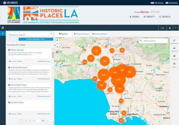
HistoricPlacesLA, the city’s heritage resource inventory and management system, launched in 2015 with a partial set of SurveyLA data (see City of Los Angeles, Office of Historic Resources. n.d. HistoricPlacesLA. Accessed June 20, 2023. https://hpla.lacity.org/). In 2016 the OHR brought on a full-time data manager, and by 2019 integration of SurveyLA data within HistoricPlacesLA was complete.
At this writing, HistoricPlacesLA includes records on over fifty-seven thousand heritage resources (fig. 5.2). Integration of other heritage data not derived from SurveyLA continues, including work to enhance and keep up to date records on designated and newly identified resources and districts.
The system support, hosting, and maintenance has now been fully and permanently transitioned from the GCI to City Planning, attesting to the city’s long-term commitment to manage, update, and expand its heritage inventory.
Notes
-
Although the city’s 1962 Cultural Heritage Ordinance called for a survey, no comprehensive program was ever undertaken. ↩︎
-
The customized application was not designed for longevity; the software is now outdated and there are no plans to upgrade. ↩︎
-
The system is known as ZIMAS (Zone Information and Map Access System); see http://zimas.lacity.org/. ↩︎