Historic Environment Records in England
Local heritage inventories have a long pedigree in England, from the early card indexes compiled in the 1960s to the present system of digital databases and mapping systems known formally as historic environment records (HERs),1 which provide a single point of access to information about the heritage of an area. There are now more than eighty HERs based in local government authorities around England, providing coverage of the entire country.
Many resources are available to guide the operators and users of England’s HERs:
-
Historic England publishes specifications to guide local authorities delivering HERs (Historic England. 2019. A Guide to Historic Environment Records (HERs) in England. UK: Historic England. https://historicengland.org.uk/images-books/publications/guide-to-historic-environment-records-england/heag266-guide-hers-england/).
-
MIDAS Heritage, the U.K. Historic Environment Data Standard, defines what information should be included on HERs when recording heritage information (English Heritage. 2012. MIDAS Heritage—The UK Historic Environment Data Standard, version 1.1. London: English Heritage. https://historicengland.org.uk/images-books/publications/midas-heritage/).
-
The United Kingdom’s Forum on Information Standards in Heritage (FISH) maintains standard vocabularies used by all HERs (Forum on Information Standards in Heritage (FISH). n.d. “FISH Vocabularies.” Accessed July 27, 2023. https://www.heritage-standards.org.uk/fish-vocabularies/).
-
Working guidelines for HERs have been published as an online wiki (Informing the Future of the Past: Guidelines for Historic Environment Records. n.d. Accessed April 26, 2020. https://archaeologydataservice.ac.uk/ifp/).
-
The HER Forum provides an online discussion list and holds in-person meetings to share best practices.2
These resources ensure that HERs are mutually comprehensible across the whole country, while allowing them to retain locally distinctive information. The benefits of a standardized approach can be seen on the Heritage Gateway website, which allows users to search across multiple participating HERs as well as national datasets maintained by Historic England (Heritage Gateway. n.d. “Quick Search.” Accessed December 7, 2023. https://www.heritagegateway.org.uk/gateway/).
A typical HER in England maintains a core data set of three linked data types:
-
Monuments: physical remains that provide information about the past, also known as heritage assets
-
Investigative Activities: activities undertaken to record and interpret heritage assets and their contexts, also known as events
-
Sources: bibliographic and spatial data, in which information about monuments and investigative activities is recorded
Although a local HER is not a primary archive, each commonly holds digital and/or physical copies of sources for reference purposes. All HER information is held on behalf of and for the benefit of the public and is available for consultation through the relevant local authority.
HERs and Archaeological Heritage Management
HERs are typically maintained by local government planning authorities, who are responsible for considering approval of applications for new buildings and other construction projects.
As part of new construction projects, developers are required by English planning policy to submit a full appraisal of heritage assets that will be affected by their scheme and any impacts upon them. In turn, government officials are expected to validate submissions against their own knowledge of the site and its wider context. Both parties are expected to base their conclusions on information held in the relevant HER.
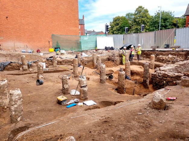
Archaeological investigation can add significant costs to new development, often to the extent of making the project unprofitable for the developer. This fact makes it vital for the HER to be as up to date and accurate as possible; doing so is typically the duty of a dedicated records officer. It is equally important that the information held by the HER can be easily understood by nonspecialists, to enable effective decision-making by developers before resources are committed to a project (fig. 13.1).

Typically, construction projects in Lincoln involve discussions between the applicant and the heritage team, which comprises the city’s experts in built heritage and archaeology. For both Lincoln’s archaeological and conservation officers,3 the HER is a key resource to identify any relevant historic buildings or archaeological remains that may have been recorded from previous excavations in the area affected by the proposed development.
One of the most effective techniques for this effort is map regression, whereby all available historic maps of a location are compared. This technique is made possible through the Lincoln HER database known as Arcade, described below. Map regression can tell us whether a site that currently appears empty has previously been built upon, or vice versa. This information is useful for establishing whether archaeological remains may exist under later buildings and for identifying undeveloped sites that may contain undisturbed archaeological deposits.
Following desk-based assessment, further intrusive archaeological investigation may be required to gather more accurate information. Those findings can be combined with existing information from the HER to provide an archaeological predictive model. The model can be used to inform the design of foundations, allowing remains to be preserved in situ where possible, or excavated in targeted interventions if harm or loss cannot be avoided.
Any resulting information is submitted to the HER, where it is recorded to inform future applications and decisions. Thus, the heritage record is constantly enhanced and updated, with benefits to the academic community through the gathering of knowledge, to developers in the greater certainty and confidence of their finances and timetables, and to the public through greater understanding of their past and in the provision of new, sustainable construction.
Arcade: Lincoln’s HER Information System
In Lincoln, the information system used to perform all these tasks is called Arcade (City of Lincoln Council. n.d. Arcade. Accessed June 20, 2023. https://arcade.lincoln.gov.uk/); it is an Arches-powered heritage inventory launched in 2018 (see chapter 4). The system enables real-time online access to the city’s HER and is used by academic and commercial researchers to gain a better understanding of the city’s heritage (fig. 13.2).
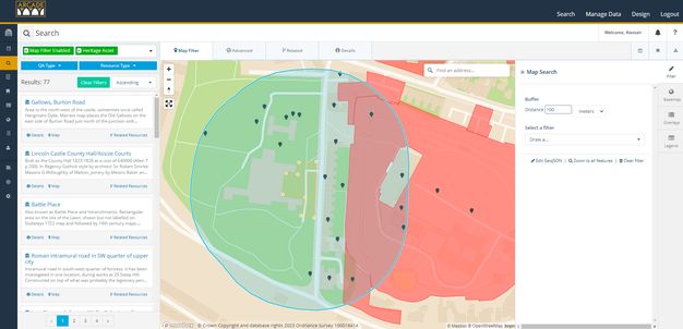
Where data is restricted, such as that relating to ongoing planning applications or the detailed locations of sensitive archaeological sites, it is maintained in a protected area of the system. All other information in Lincoln’s HER is publicly accessible on the Arcade system (fig. 13.3).
For trusted users outside the organization, including members of local heritage societies or university staff, Arcade provides for data entry and upload. This capability has sparked new crowdsourcing initiatives, including providing a volunteer group with the ability to make provisional additions to Arcade (subject to verification) to identify and help protect particular historic buildings and enhance existing records. Such tasks would traditionally have been undertaken solely by council officers, who are now free to spend more time on casework, such as reviewing development proposals.
Lessons and Considerations
The experience of the English HER sector suggests the following key principles for incorporating archaeological data into heritage inventories:
-
Data should be collected and maintained according to defined standards and vocabularies.
-
A data collection strategy should be employed to ensure that records contain an appropriate and proportionate level of detail and can be restricted where necessary.
-
Sources should include historic maps where available, to allow for historic analysis and map regression.
-
The interpretation of information should take into account the needs of a range of audiences and disciplines.
-
The data set should be considered a living, evolving resource, with appropriate resourcing to incorporate new information as it becomes available.
Adhering to these principles has helped ensure the effectiveness of Lincoln’s HER as an essential tool for the city’s archaeological heritage management.
Notes
-
Historic environment record (HER) is the term used in the United Kingdom for heritage inventories. ↩︎
-
The HER Forum online email list is available at https://www.jiscmail.ac.uk/cgi-bin/webadmin?A0=herforum. ↩︎
-
Archaeology and historic building conservation are separate (though linked) disciplines in the U.K. heritage community. Each derives its authority and place in the planning system from a different set of legislation and guidance. However, in practice, both archaeological and conservation officers are required to employ standardized heritage data in their work, and Lincoln is at the forefront of a growing movement to provide a unified information system that serves both equally. ↩︎