|
|
 |
|
 Place Name Place Name
Alternate Place Name(s)
Spatial Coordinates
Geographical Descriptive Note
These categories are designed to record appellations by which
geographic places are or were known. A geographic place can
be defined in this context as any physical point or area on
the earth's surface. It may range in scope from an entire
continent to a specific street address.
Locations can be expressed in terms of geographic entities
(e.g., North America), geopolitical entities (e.g.,
Canada ), addresses, and map coordinates. A geographic
entity, in this context, is an area of the earth's surface,
the boundaries of which are defined often by natural features
such as seas, rivers, and mountains (e.g., the Balkan Peninsula).
They may be linguistic and cultural units (e.g., Scandinavia),
or groups of islands (e.g., Caribbean, Polynesia).
Geopolitical entities are taken to mean independent sovereign
states, these varying in size from the People's Republic
of China down to the independent principality of Monaco.
Locational information can be used to record:
- The locus or loci of activity of an object's maker or
a related person or people
- The location of a corporate body
- The location of a subject or built work
- The location of the repository of the item
Geopolitical Entities
One of the problems of recording names of geopolitical entities
is their relative impermanence: countries appear and disappear
and change their names and/or their borders. Repositories
holding information relating to a number of countries need
to be aware of any changes of relevance to their collections
and to update their records accordingly. Some institutions
are likely to require the flexibility to be able to record
and retrieve by the name of a geopolitical entity at the time
when:
- It was the locus of activity of a maker or any other person
or the location of corporate body
- A subject was depicted
- A particular work was built
For example, in the case of a draftsman who lived in the
late fifteenth century and whose locus of activity was Pisa,
it may be useful to record the name under both Italy
(the present geopolitical entity of which Pisa is a
part) and Republic of Florence (the geopolitical entity
of which Pisa was a part at the time when it was the
draftsman's locus of activity). Doing this on an automated
system requires allowing for two or more occurrences of the
category designed to hold this information. It is also desirable
to indicate which is the name of the current geopolitical
entity and which are the names of former ones. The problems
of creating a data structure which will enable users to relate
the current names of localities to the names by which they
were known in the past has been addressed by the Historical/Geographical
Databank Project of the Thesaurus Artis Universalis (TAU)
[1] and AHIP's Thesaurus of Geographic
Names. These systems are complex relational databases
and can be implemented only as part of a sophisticated geographic
location authority file. For most practical purposes, the
furthest that repositories are likely to wish to go in this
direction is the creation of a relatively simple authority
file that allows for the cross-referencing of past names to
present names, the relationship between the names being explained
in an accompanying note category (Geographical Descriptive Note).
Geographic Entities
The ability to record and retrieve by geographic entity enables
the user to locate an item, person, subject, or work at a
broader level of description than geopolitical entity. A user
may know that a subject is, for instance, North African,
but not the country in which it originated. Also, the changeability
of national boundaries can make geographic entities more meaningful
than geopolitical ones in some instances. The names Italy
and Germany are, for example, applied to those areas
at periods in history when neither existed as geopolitical
units. It can, however, be difficult to determine to which
geographic entity a location belongs. Also, many entities
are themselves parts of larger entities. For instance, the
Iberian Peninsula is a part of Western Europe,
which is itself part of Europe. For retrieval to be
reliable, repositories should apply guidelines on which names
are admissible and how those relate to other broader and narrower
names for the same entities, or parts thereof. This area of
terminology control is, however, beyond the scope of the Guide.
Address
An address can be used to locate a person, corporation, subject,
built work, or repository within a given geopolitical entity.
When designing record formats, it is important to recognize
that certain types of information are themselves made up of
a number of individual pieces of information. The address
of a building, for example, comprises a number of separate
but related elements, e.g., 10 (number), rue du
Parc Royal (street), Temple (area), Paris
(city), \xCEle de France (region), 75003 (code),
France (country). These elements are combined to form
an address that is unique to a building, providing a means
of locating and identifying it. The elements that combine
to create an address form levels in a hierarchy, ranging from
country down to name and number. As a result, these elements
have the potential not only to locate an individual building,
but also to act as a means of finding all the buildings referred
to in a database that have one or more address elements in
common (e.g., all buildings on a particular street, all buildings
in the Netherlands, or all buildings in the town of
Gouda in the province of Holland in the Netherlands).
The narrower the search, the more address elements need to
be combined in order to ensure that the correct information
is retrieved.
In some instances the name of one of the narrower levels
may imply the name of the broadest level, or possessing whole.
For example, if a building is described as being in Gelderland,
it can be inferred that it is in the Netherlands. It
is not possible, however, to rely on this whole-part relationship,
because some narrow terms are not unique and can therefore
imply the name of more than one possessing whole. If, for
example, a searcher wished to find all buildings in Cambridge,
Massachusetts, it would be insufficient to search only
by the name of town, for that would retrieve records holding
information on buildings in Cambridge, Ontario; Cambridge,
Maryland; or Cambridge, England.
In many manual retrieval systems hierarchical searches are
made possible by creating geographic location files with index
cards for each country, behind which are placed cards for
each state within the individual countries, and so on down
through the levels of area and street, to cards that provide
cross-references to individual buildings. Computer-based systems
have the potential, however, to reduce the amount of effort
needed to achieve this end. Hierarchical searches can be made
by any category of information that is susceptible to subdivision
by recording the components in separate categories, each of
which is reserved for a particular element:
Number:
|
10
|
Street:
|
rue du Parc
|
Area:
|
Temple
|
Town/City:
|
Paris
|
State/Region:
|
\xCEle de France
|
Country:
|
france
|
code:
|
75003
|
A number of the pieces of locational information recorded
in the above example may be redundant for purposes of generating
a postal address for a building, but are nonetheless useful
aids for retrieval. The adoption of this type of approach
greatly increases the flexibility of a system, not only allowing
for retrieval at every level of the hierarchy, but also increasing
the number of ways in which the information retrieved can
be manipulated and displayed (e.g., by such means as tabulated
lists, sorted under one or more levels of the hierarchy).
Also, the more categories the address information includes,
the more specific can be the requests for information (e.g.,
all architects whose locus of activity was Chicago,
or all items which are depictions of skyscrapers
on Fifth Avenue, New York). The way in which
address information is structured is likely to reflect the
needs of the institution. For example, some institutions may
wish to record down to the level of postal codes, but many
will not. If detailed locational information derived from
a number of countries is to be recorded in a structured form,
the structure must be able to accommodate differences in the
ways those countries express addresses.
Address elements, like geopolitical entities, are subject
to change. Within the last twenty years a number of historic
English counties have disappeared while new ones have been
created and a number have changed their boundaries. Similarly,
cities grow and absorb surrounding towns and villages, and
may change their names, often for reasons of nationalism or
politics, e.g., Salisbury (Rhodesia) to Harare
(Zimbabwe) and St. Petersburg to Petrograd
to Leningrad and back to St. Petersburg.
It may be required of a system that it be able to record
one or more former or alternate addresses, in addition to
a present one. If an automated system is to be capable of
recording this information, it must allow for a number of
occurrences of the section of categories corresponding to
individual address elements.
It is not always possible to locate a subject with any degree
of precision. In some instances the town or city may be known
but not a street address, while in others the country alone
may be known.
Records designed to hold geographical information must be
able to accommodate considerable variation in the degree of
specificity of locational information from record to record.
Spatial Coordinates
Spatial coordinates are sets of numbers\x97sometimes with associated
letters\x97that locate points on the earth's surface. Most systems
use coordinates made up of two numbers, these corresponding
to an x and a y axis (although some use three).
Example:
The Thesaurus of Geographic Names expresses the position
of Tuscany as:
Latitude:
|
43.25 Direction: N
|
Longitude:
|
11.00 Direction: E
|
Coordinates are particularly useful when a built work must
be located with accuracy but the address elements are not
sufficient, as with a lighthouse. Another advantage of map
coordinates is that while addresses change, coordinates do
not.
The importance of spatial coordinates has grown with the
development of computer-based Geographic Information Systems
(GIS). Using GIS can make it relatively simple to retrieve
all records that have the coordinates of any location on a
map.
The recording of coordinates is of most importance to regional
and national bodies engaged in documenting archaeological
sites and historic buildings. However, it would be impractical
for the majority of cataloguing institutions to record this
information. For this reason map coordinates are not regarded
as core, but are recommended for use by institutions that
are in a position to record them with relative ease.

Category: Place Name
Definition:
The appellation preferred by the repository for a given geographic
place.
Discussion:
Retrieval of entries via geographic information is a basic
requirement. See the following categories for more specific
information:
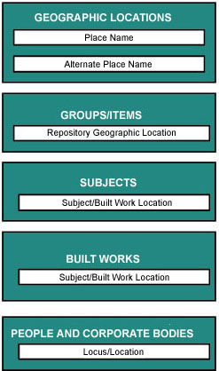
Repository Geographic Location, in Group/Item Identification
Subject/Built Work Location
Locus/Location, in People/Corporate Bodies
Any geographic place may have a name. It is suggested that
the following types of places (or their equivalents) be included
for any of the above categories, when appropriate:
- Geographic entities
- Geopolitical entities
- State/Region
- City/Town
- Area
- Road/Street
- Number
- Code
In most circumstances, a geographic authority record must
contain at least one known proper place name.
Terminology:
Names of places can be transcribed from items or bibliographic
sources. The Times Atlas is recommended as a preferred
source, where applicable. It is also recommended that the
vernacular form of the name be recorded, either as Place Name or
Alternate Place Name(s).
Implementation:
access point
authority-controlled
optional
hierarchical
repeatable
Category:
Alternate Place Name(s)
Definition:
Variant names by which the place is or was known. This includes
names of places that have changed over time, variations of
spellings, and translated names.
Discussion:
Recording alternate names allows retrieval by more than one
name for a given geographic location, e.g., Leghorn
for Livorno. In other words, this category provides
a cross-reference to Place Name.
Implementation:
access point
authority-controlled
optional
hierarchical
repeatable
Category:
Spatial Coordinates
Definition:
A set of numbers used to locate points on the earth's surface.
Discussion:
Spatial coordinates can be used to record a location, in the
absence of a proper place name.
Place names change and can be imprecise. Further, there is
no inherent correspondence between a name and a place. Spatial
coordinates, on the other hand, provide an unchanging record
of a given location.
Example:
The National Archives of Canada express the spatial location
of Ottawa as:
latitude:
|
45°25'
|
Longitude:
|
75°42'
|
The two axes of coordinates should, ideally, be recorded
separately, particularly if the repository is considering
the use of a GIS.
Implementation:
access point
format-controlled: numeric
optional
repeatable
Category:
Geographic Descriptive Note
Definition:
An explanatory text concerning any aspect of a geographic
place to which the cataloguer needs to draw attention.
Discussion:
This note can be used to qualify any information about a place,
including its historic names.
Example:
The name Toscana derives from the early inhabitants, the
Etruscans, who settled here ca. 500 BC. Under Diocletian it
was part of Tuscia et Umbria. Most of Tuscany was loyal to
the Holy Roman Emperors. The modern region was established
in 1948.
(excerpt from Descriptive Note on Tuscany in Thesaurus
of Geographic Names)
Implementation:
descriptive
optional
single occurrence
|
|
|
|