|
|
3 |
EDITORIAL RULES, CONTINUED |
|
|
|
|
3.7 |
|
Coordinates
Included in this chapter
- Coordinates
Latitude:
Degree; Minute; Second; Direction; Decimal Degrees
Longitude:
Degree; Minute; Second; Direction; Decimal Degrees
- Bounding Coordinates
Least Latitude:
Degree; Minute; Second; Direction; Decimal Degrees
Most Latitude:
Degree; Minute; Second; Direction; Decimal Degrees
Least Longitude:
Degree; Minute; Second; Direction; Decimal Degrees
Most Longitude:
Degree; Minute; Second; Direction; Decimal Degrees
- Elevation
Elevation:
Feet; Meters
- Example
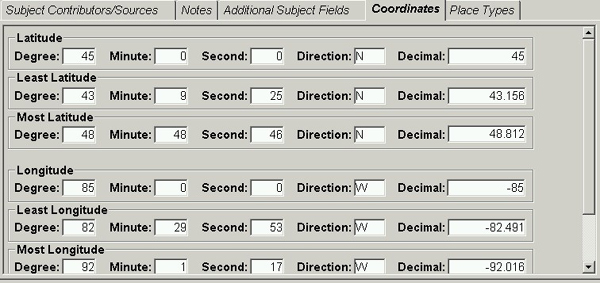
[for Great Lakes Region in VCS]
|
 |
|
| |
|
|
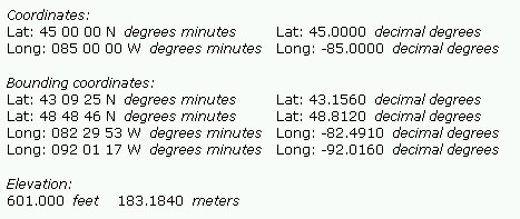
[end-user display for Great Lakes Region] |
|
 |
| |
|
|
|
|
3.7.1 |
|
|
Coordinates |
|
|
|
|
|
3.7.1.1 |
|
|
Definition
Geographic coordinates indicating the point on the globe where
the place is located, expressed in degrees/minutes/seconds
and decimal fractions of degrees.
So far as is possible given that TGN is compiled from various contributors, coordinates in TGN are compliant with following standards: ISO 6709 Standard representation of geographic point location by coordinates, using the WGS 84 (revised 2004) coordinate reference system. |
| |
|
|
|
| 3.7.1.2 |
|
|
Fields
Latitude:
Degree; Minute; Second; Direction
Decimal Degrees
Longitude:
Degree; Minute; Second; Direction
Decimal Degrees
|
| |
|
|
|
|
3.7.1.3 |
|
|
Values
- Valid values are controlled by VCS.
- Latitude: Degree: 0 to 90; Minute: 0 to 60; Second:
0 to 60; Direction: N or S (for north or south)
- Longitude: Degree: 0 to 180; Minute: 0 to 60; Second:
0 to 60; Direction: E or W (for east or west)
- Latitude Decimal Degrees: 0 to +/-90 with decimal
fractions
- Longitude Decimal Degrees: 0 to +/-180 with decimal
fractions
|
|
|
|
|
|
3.7.1.4 |
|
|
Sources |
| |
|
|
|
|
3.7.1.4.1 |
|
|
List of Sources
Sources for coordinates are standard general reference works,
in the following order of priority:
- NGA GEOnames query (for places in nations other than the
USA) http://earth-info.nga.mil/gns/html/index.html
- USGS National Mapping Information query form (for places
in the USA) http://geonames.usgs.gov/
- The index of Times Comprehensive Atlas of the World, 13th ed.
- The index of Oxford Atlas of the World, 20th ed.
- The index of the National Geographic Atlas of the World, 9th edition
- The index of Rand McNally New International Atlas,
25th anniversary edition
- Columbia Gazetteer of the World, 2nd edition
- Other authoritative hardcopy or online sources.
- If you consult multiple sources and the coordinates vary
from source to source, prefer the most current and authoritative
source.
- Caveat: If you use sources other than the ones
named above, carefully ascertain that the coordinates listed
in the source represent the same type of standard geographic
coordinates (also called geographical or terrestrial coordinates)
compliant with ISO 6709 and WGS 84 (revised 2004), as preferred in TGN. There are other types of coordinate systems,
including various local systems, other national systems,
and systems derived by other criteria. How can you tell
if the coordinates in your source are compatible with TGN
data? Compare the numbers used in the coordinate system
of your source with coordinates of other TGN records for
places that are near the place you are recording.
- GPS: If you have access to a Global Positioning
System (GPS) receiver that has been proven to be accurate
and reliable, you may use this as your source of coordinates.
The Global Positioning System (GPS) is a satellite-based
navigation system made up of a network of between 24 and
32 satellites, compliant with with ISO 6709 and WGS 84 (revised 2004). Originally intended for military applications,
the government made the system available for civilian use
in the late 1980s and handheld receivers are commercially
available today, including as applications on smart phones. A good quality GPS will be able to locate
a position to within 40 meters or better. If you use a GPS
for coordinates, include the citation Global Positioning
System (GPS) receiver (n.d.) in the Subject Source and put
the brand, model, and date of the reading in the Page field.
|
|
|
|
|
|
3.7.1.5 |
|
|
Discussion
- Standards: TGN endeavors to comply with the ISO 6709 Standard representation of geographic point location by coordinates. ISO 6709 is the international standard for representation of latitude, longitude and altitude for geographic point locations. ISO 6709 provides a means for indicating the coordinate reference system used, which is WGS 84 (revised 2004) in TGN.
TGN endeavors to use WGS 84 coordinate reference system, so far as is possible given that TGN is compiled from various contributors' data. WGS 84 is the reference system used most widely in the world: It is the standard used by the US Department of Defense and used for Global Positioning Systems (GPS). WGS 84 is compatible with the International Terrestrial Reference System (ITRS). WGS 84 is an Earth-centered, Earth-fixed terrestrial reference system and geodetic datum. WGS 84 is based on a consistent set of constants and model parameters that describe the Earth's size, shape, and gravity and geomagnetic fields. It is defined in the US National Geospacial-Intelligence Agency (NGA, formerly NIMA) Technical Report 8350.2. WGS 84 uses the EGM96 (Earth Gravitational Model 1996) geoid, last revised in 2004.
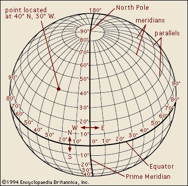
- Latitude: Geographic latitude is the angular distance north or south
of the equator, measured along a meridian. Parallels of
latitude are equidistant circles drawn around the globe
parallel to the equator. Measurements along the parallels
are traditionally given in degrees, minutes, and seconds
(counted in increments of 60, as with a clock), combined
with a directional indicator for north (N) or south (S).
The equator is at 0 degrees; 90 degrees north is the North
Pole, 90 degrees south is the South Pole. The greatest possible
latitudes are 90° N and 90° S.
- Longitude: Longitude is the angular distance east or west of the
Prime Meridian, which runs through Greenwich, England. Meridians
are imaginary north-south lines on the Earth's surface that
connect both geographic poles, used to measure longitude.
Measurements along the meridians are traditionally given
in degrees, minutes, and seconds (counted in increments
of 60, as with a clock), combined with a directional indicator
for east (E) or west (W). The prime meridian is at 0 degrees;
180 degrees is the International Date Line. The greatest
longitude is measured 180° both east and west of the
prime meridian.
- Given that meridians are closer together nearer the
poles and further apart nearer the equator, any flat projection
of the globe as a grid with 45-degree angles on a map
is somewhat inaccurate. As an editor, you generally do
not need to compensate for this inaccuracy, but you should
be aware of it when you consult maps. Maps of the same
area may vary in appearance, depending upon what method
of projection was used.
- The combination of meridians of longitude and parallels
of latitude establishes a grid by which exact positions
can be determined. Coordinates in TGN represent the point
on the grid where latitude and longitude cross (e.g., in
the illustration below, the point at 40 degrees north and
30 degrees west is illustrated).
|
|
|
| |
|
|
image from Encyclopedia Britannica Online (2002-) http://www.eb.com/,
(accessed 11 August 2004) |
| |
|
|
|
| |
|
|
- Most of the records in the TGN include geographic coordinates
that represent a single point for each place, corresponding
to a point at or near the center of the inhabited place,
political entity, or physical feature. For linear features
such as rivers, the point represents the source of the feature.
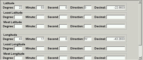
- Decimal degrees: Coordinates are expressed in degrees,
minutes, and seconds, corresponding to the standard used
in atlases and illustrated above. In TGN, coordinates are
also expressed in decimal fractions of degrees where minutes
and seconds are translated into decimal values, (e.g., 40
degrees 30 minutes 00 seconds = 40.5000 decimal degrees).
The expression of coordinates in decimal degrees is used
in Geographic Information Systems (GIS) and for other applications
where mathematical calculations are necessary. In decimal
fractions, the directional indicators (e.g., north, south,
east, or west) are not included. Instead, directions are
indicated by using sets of positive and negative numbers:
north latitude and east longitude are expressed as positive
numbers; south latitude and west longitude are expressed
as negative numbers (as in the example for Rio de Janeiro
below).
|
|
|
|
|
|
|
3.7.1.6 |
|
|
RULES |
|
|
|
|
|
|
3.7.1.6.1 |
|
|
Minimum requirements
Coordinates are not required, but they are strongly recommended.
- It is a higher priority to include coordinates for administrative
entities than for physical features (because administrative
entities - such as inhabited places - are typically more
important for catalogers of art and cultural heritage materials,
the intended audience of TGN).
- Enter only valid values, as listed under Values above.
Do not use punctuation except with decimal degrees, where
a period must be used as the decimal point separating the
whole number from fractions of a degree and a hyphen is
used for negative numbers.
|
|
|
|
|
|
|
3.7.1.6.2 |
|
|
Degrees/minutes/seconds vs. Decimal degrees
Atlases and geographic dictionaries, including the sources
listed above, will typically record coordinates in degrees/minutes/seconds
rather than in decimal degrees. Carefully transcribe the numbers
and direction into the appropriate fields in VCS. Allow the
system to automatically fill in the decimal value.
- If your source lists decimal values, carefully transcribe
them in the Decimal field, including the period for decimal
fractions and a hyphen for the negative numbers, as appropriate.
Allow the system to automatically fill in degrees/minutes/seconds
for you.
- Example
[for Rio de Janeiro, in VCS]
|
|
|
| |
|
|
|
| |
|
|
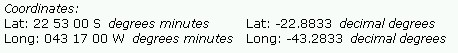
- Caveat: You will not be able to correctly transcribe
zeroes as found in your sources into the VCS fields. Due
to a technical idiosyncrasy of VCS, it will not save more
than one zero in the degree/minute/second fields; it will
not save zeroes to the far right of the decimal point in
the Decimal field either. Note that publication algorithms
compensate for this flaw by adding zeroes in accord with
geographic information standards, which require zeroes to
fill in the required positions (compare the coordinates
for Rio de Janeiro in VCS above and as published, below).
- Example
[for Rio de Janeiro, in an end-user display]
|
|
|
| |
|
|
|
|
|
|
3.7.1.6.3 |
|
|
What do the coordinates represent?
As described in the Discussion above, the coordinates
are intended to represent a point at or near the center of
a place. For linear features, such as a river, the point should
represent the source of the feature.
- Inhabited places and physical features: Record
coordinates as found in your source. As an editor, you typically
should transcribe coordinates from a published source; do
not use a map to estimate coordinates for small places,
such as inhabited places or small features, because they
will be too inaccurate.
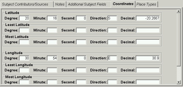
- Regions and large physical features: In some cases,
such as for a general region, large physical feature, or
other area, you may be required to estimate coordinates
for the center of the area because they are not included
in your sources. In general, the accuracy of the center
of large features is not expected to be as precise as for
small entities, therefore it is permitted to estimate coordinates
for large areas and features by using a map.
- Use a large map (e.g., in an atlas); on the map, draw
an imaginary line through the vertical center of the
area; draw another imaginary line through the horizontal
center of the area. Record the coordinates representing
the point where the two imaginary lines intersect.
- If you use a map as described above, Record zeroes
for seconds; if you record very specific numbers, it
gives the mistaken impression that you have measured
the center by a scientific means (whereas, you are in
reality only estimating the center, based on sight).
- Example
[for the Kalahari Desert, Africa]
|
|
|
| |
|
|
|
|
|
|
3.7.1.6.4 |
|
|
Accuracy of the coordinates
Coordinates in the sources named above are approximate and
are intended only for finding the place on the map. (Of course,
you must be careful to accurately transcribe them, none-the-less.)
- Sensitive sites: It is standard practice to avoid
giving accurate coordinates for archaeological sites, caves,
other environmentally sensitive sites, or politically sensitive
sites. As an editor, you need not be concerned with this,
provided you find the coordinates in the standard published
sources named above; feel free to record them in TGN. However,
if you somehow have access to precise coordinates (e.g.,
by accessing materials belonging to an archaeological project),
do not record these more accurate, unpublished coordinates
in TGN.
|
| |
|
|
|
|
|
|
3.7.1.6.5 |
|
|
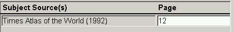
Citing your source
The coordinates fields are not linked directly to the source
table. Therefore, you should cite the source for your coordinates
in the Subject Source area, if you have not cited it elsewhere.
(If the same source was used for names and/or the descriptive
note, and the source is thus cited in these areas, you needn't
list it again under Subject Source.)
|
|
|
| |
|
|
|
|
|
| |
|
|
- If you used a GPS for coordinates, include the citation
Global Positioning System (GPS) receiver (n.d.) in the Subject
Source and put the brand, model, and date of the reading
in the Page field.
|
|
|
|
3.7.2 |
|
|
Bounding Coordinates |
|
|
|
|
|
|
|
|
3.7.2.1 |
|
|
Definition
A set of four lines expressed as geographic coordinates, indicating
four sides of a box encompassing a region, feature, or other
area. |
|
|
|
|
|
|
|
|
3.7.2.2 |
|
|
Fields
Least Latitude:
Degree; Minute; Second; Direction
Decimal Degrees
Most Latitude:
Degree; Minute; Second; Direction
Decimal Degrees
Least Longitude:
Degree; Minute; Second; Direction
Decimal Degrees
Most Longitude:
Degree; Minute; Second; Direction
Decimal Degrees |
|
|
|
|
|
|
|
|
3.7.2.3 |
|
|
Values
- Valid values are controlled by VCS.
- Least and Most Latitude: Degree: 0 to 90; Minute:
0 to 60; Second: 0 to 60; Direction: N or S (for north or
south)
- Least and Most Longitude: Degree: 0 to 180; Minute:
0 to 60; Second: 0 to 60; Direction: E or W (for east or
west)
- Least and Most Latitude Decimal Degrees: 0 to
+/-90 with decimal fractions
- Least and Most Longitude Decimal Degrees: 0 to
+/-180 with decimal fractions
|
|
|
|
|
|
|
|
|
3.7.2.4 |
|
|
Sources |
|
|
|
|
|
|
|
|
3.7.2.4.1 |
|
|
List of Sources
- Estimated coordinates: Most standard sources,
such as atlases and geographic dictionaries, do not include
bounding coordinates. In most cases, you will need to consult
a map and estimate bounding coordinates by sight. Standard
atlases with appropriate maps include the following:
- Times Comprehensive Atlas of the World, 13th ed.
- Oxford Atlas of the World, 20th ed.
- National Geographic Atlas of the World, 9th
ed.
- Rand McNally New International Atlas, 25th anniversary edition
- Coordinates from a source: Some sources include
bounding coordinates. Use only authoritative sources, such
as official Web sites for a national or state government.
- If you consult multiple sources and the coordinates vary
from source to source, prefer the most current and authoritative
source.
|
| |
|
|
|
|
|
|
3.7.2.5 |
|
|
Discussion
- Bounding coordinates define the limits of coverage of
an area or feature expressed by latitude and longitude values
for the western-most, eastern-most, northern-most, and southern-most
points (as illustrated below).
|
| |
|
|
|
|
|
|
|
| |
|
|
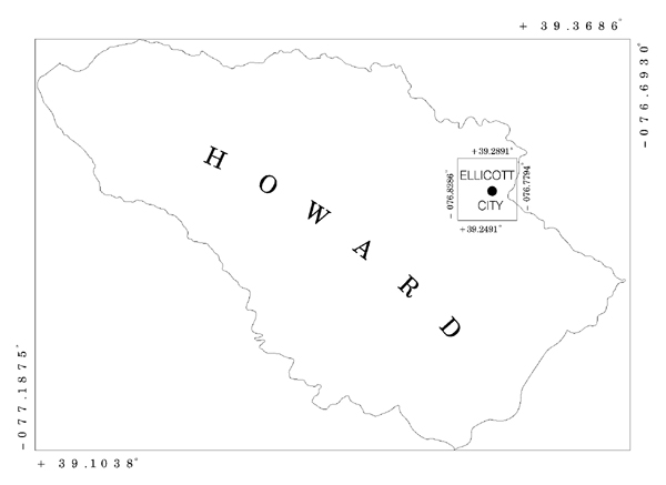
Maryland State Government Geographic Information
Coordinating Committee Bounding Coordinates for Howard County.
http://www.msgic.state.md.us/ (12 August 2004) |
|
|
|
|
|
|
|
| |
|
|
- In TGN, bounding coordinates are called Least and Most,
referring strictly to the numerical value of the decimal
coordinates; obviously, these numbers could be mapped to
the cardinal directions as the western-most, eastern-most,
northern-most, and southern-most points.
- Bounding coordinates define a quadrilateral, meaning a
figure bound by four straight lines. The figure so formed
is generally a rectangle, meaning that the lines comprise
two parallel pairs, joined at the four points in right angles.
|
|
|
|
|
|
|
|
|
3.7.2.6 |
|
|
RULES |
|
|
|
|
|
|
|
|
3.7.2.6.1 |
|
|
Minimum requirements
Bounding coordinates are not required. Enter them
as editorial priorities allow.
- If you enter bounding coordinates, it is required to also
enter Coordinates (representing a point in the center of
the area; see 3.7.1 Coordinates above).
- If you enter one bounding coordinate, you must enter coordinates
for all four sides of the bounding box.
- Enter only valid values, as listed under Values above.
Do not use punctuation except in decimal degrees, where
a period should be used as the decimal point separating
the whole number from fractions of a degree and the hyphen
is used for negative numbers.
|
|
|
|
|
|
|
3.7.2.6.2 |
|
|
When to list bounding coordinates
It is generally more important to list bounding coordinates
for a large area or large physical feature that is not well
represented by a single set of coordinates (representing one
point), than for a smaller place.
- However, bounding coordinates may be recorded for a relatively
small area, such as an inhabited place or physical feature,
if they are supplied by your source. Do not acquire bounding
coordinates by trying to draw an imaginary bounding box
for a small area
|
|
|
|
|
|
|
3.7.2.6.3 |
|
|
Degrees/minutes/seconds vs. Decimal degrees
If your source lists decimal values, carefully transcribe
the north-, south-, east-, and west-most extents of the area
or feature into the Most and Least fields for latitude and,
including decimal fractions and a hyphen for the negative
numbers, as appropriate. Allow the system to automatically
fill in degrees/minutes/seconds/direction for you.
- If your source lists bounding coordinates in degrees/minutes/seconds,
carefully transcribe the numbers and direction into the
appropriate fields. Allow the system to automatically fill
in the decimal value.
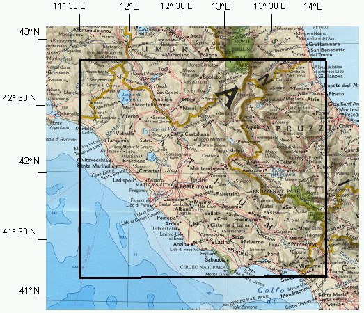
- If you use a map to determine for yourself the four points
representing the area or feature, draw an imaginary box
around the area or feature (as for the illustration of Lazio/Latium
below). Draw the tightest box possible to include the area
or feature. Make the lines perpendicular (the corners of
the box should be right angles), unless instructed to do
differently by your supervisor. For each of the four imaginary
lines, enter degrees/minutes/seconds and direction of latitude
or longitude in the appropriate Most and Least fields. Allow
the system to automatically fill in the decimal value.
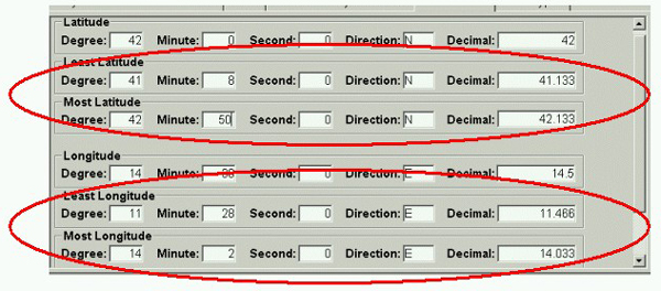
- Most Latitude must be a number greater than Least Latitude;
Most Longitude must be a number greater than Least Longitude.
As you calculate which fields to use for numbers that
are greater and smaller than each other, keep in mind
that Most and Least refer to the decimal degrees, which
may be negative numbers (north latitude and east longitude
are expressed as positive numbers; south latitude and
west longitude are expressed as negative numbers).
- Example
[for the region of Lazio (Latium), Italy]
|
|
|
| |
|
|
|
| |
|
|
|
|
|
| |
|
|
Italy, detail of a map insert from National
Geographic Magazine, February, 1995. Bounding box added by the
author, representing coordinates 11 28 E, 14 02 E and 41 08
N, 42 50 N. |
|
|
|
|
|
|
3.7.2.6.4 |
|
|
Accuracy of the coordinates
Bounding coordinates, whether found in sources or
determined by the editor examining a map, are generally approximate
and are intended only for finding the place on the map.
- If you have estimated the bounding coordinates by sight
by consulting a map, record the seconds as zero to avoid
the impression that the coordinates are more accurate than
they actually are.
|
|
|
|
3.7.3 |
|
|
Elevation |
|
|
|
|
|
|
3.7.3.1 |
|
|
Definition
The vertical distance of the place above or below mean sea
level. |
|
|
|
|
|
|
3.7.3.2 |
|
|
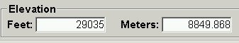
Fields
|
| |
|
|
|
|
3.7.3.3 |
|
|
Values
- Valid values are controlled by VCS.
- Elevation Feet: Positive or negative numbers, including
decimal fractions.
- Elevation Meters: Positive or negative numbers,
including decimal fractions.
|
|
|
|
|
|
|
|
|
3.7.3.4 |
|
|
Sources |
| |
|
|
|
|
|
|
3.7.3.4.1 |
|
|
List of Sources
Geographic dictionaries, encyclopedia articles, and other
sources may include elevation in the description of the place.
Atlases sometimes include elevation for peaks and ocean floor
features on the maps (typically elevation is not listed with
the coordinates, which are generally found in the indexes
of atlases). The following sources are preferred:
- United States Geological Survey (USGS). Geographic
Names Information System (GNIS) [online database].
Washington, DC: U.S. Geological Survey, 1998-. http://geonames.usgs.gov/
(27 February 2014). (only for places in the USA).
- National Geospacial-Intelligence Agency GEOnames (for places in nations other than the USA) http://earth-info.nga.mil/gns/html/index.html (27 February 2014).
- Times Comprehensive Atlas of the World. 13th comprehensive
ed. New York: Times Books, 2011.
- Oxford Atlas of the World. 20th ed. New York:
Oxford University Press, 2013.
- National Geographic Atlas of the World. Revised
9th ed. Washington: National Geographic Society, 2010.
- New International Atlas. 25th Anniversary Ed.
Chicago: Rand McNally,
2008.
- Encyclopaedia Britannica. Britannica Online. Chicago:
Encyclopedia Britannica, Inc., 2002-. http://www.britannica.com/
(27 February 2014).
- Merriam-Webster's Geographical Dictionary. 3rd ed. Springfield, MA: Merriam-Webster, 2007.
- Columbia Gazetteer of the World. 2nd ed. New York: Columbia University Press, 2008.
- Journal articles from National Geographic, Archaeology
Magazine, or other authoritative journals.
- Official national Web sites or other authoritative
online sources.
- If you consult multiple sources and the elevation varies
from source to source, prefer the most current and authoritative
source.
- GPS: You may use a Global Positioning System (GPS)
receiver as a source for elevation if it has a built in
altimeter that has been proven accurate. The best GPS receivers
can give elevation with accuracy within 3 meters. Record
Global Positioning System (GPS) receiver (n.d.) as a Subject
Source. Note the brand, model number, and date of the reading
in the Page field.
|
|
|
|
|
|
|
|
|
3.7.3.5 |
|
|
Discussion
- In most sources, zero elevation is the height of mean
sea level, which is determined by a series of observations
at various points along the seashore taken continuously
for a given period of years. However, sea level varies from
place to place, due to ocean currents, gravity, and other
physical forces. Therefore, some sources give geoid elevation,
which is the elevation above the surface of the geoid (an
imaginary shape for the earth defined by mean sea level
and its imagined continuation under the continents at the
same level of gravitational potential). Elevation may be
determined by traditional surveying or by Global Positioning
Satellite (GPS). Elevation for a single place may vary slightly
from source to source, depending upon which method was used
to measure it and other factors.
- Elevation in TGN is intended to be approximate; therefore,
enter elevation in the Elevation field regardless of which
of the above methods is used by your source.
|
| |
|
|
|
|
|
|
3.7.3.6 |
|
|
RULES |
| |
|
|
|
|
3.7.3.6.1 |
|
|
Minimum Requirements
- Elevation is not required. Enter elevation as editorial
priorities allow.
-
If you enter elevation, it is strongly recommended to
enter coordinates (see 3.7.1 Coordinates above), if possible.
It is a higher priority to record coordinates than to
record elevation.
Use only the valid numbers, as listed under Values above.
Do not use commas or any other punctuation except for
the period, which may be used as the decimal point separating
the whole number from fractions of a foot or meter, and
the hyphen, which is used for negative numbers (that is,
for distances below sea level).
- Example
[for the Himalayas mountain system]
|
|
|
|
|
|
. |
|
3.7.3.6.2 |
|
|
How to record elevation
If your source lists elevation in feet, carefully transcribe
the feet, including a hyphen for negative numbers (i.e., below
sea level). Feet are generally rounded off; however, if your
source lists a decimal fraction for feet, include it. Allow
the system to automatically fill in the meters value.
- If your source lists elevation in meters, carefully transcribe
the value, including decimal fractions and a hyphen for
negative numbers (i.e., below sea level). Allow the system
to automatically fill in the feet for you.
- If your source lists a range of elevation, as for a mountain
range, record the highest elevation.
|
|
|
|
|
|
3.7.3.6.3 |
|
|
Citing your source
The elevation field is not linked directly to the source table.
Therefore, you should cite the source for elevation in the
Subject Source area, if you have not cited it elsewhere. (If
the same source was used for names and/or the descriptive
note, and the source is thus cited in these areas, you needn't
list it again under Subject Source.)
|
| |
|
|
|
|
Last updated 27 February 2014
Document is subject to frequent revisions |
|
|
|

|
|
|
|
|
|
|
|